Roppolo | |
|---|---|
| Comune di Roppolo | |
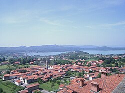 Roppolo seen from its castle. | |
 Coat of arms | |
Location of Roppolo  | |
 Roppolo Location of Roppolo in Italy  Roppolo Roppolo (Piedmont) | |
| Coordinates: 45°25′N8°4′E / 45.417°N 8.067°E | |
| Country | Italy |
| Region | Piedmont |
| Province | Biella (BI) |
| Frazioni | Babò, Borgata Salomone, Castello, Comuna di Roppolo, Morzano, Peverano, Pioglio, San Vitale |
| Government | |
| • Mayor | Renato Corona |
| Area | |
• Total | 8.7 km2 (3.4 sq mi) |
| Elevation | 307 m (1,007 ft) |
| Population (31 December 2018) [2] | |
• Total | 880 |
| • Density | 100/km2 (260/sq mi) |
| Time zone | UTC+1 (CET) |
| • Summer (DST) | UTC+2 (CEST) |
| Postal code | 13883 |
| Dialing code | 0161 |
Roppolo is a municipality in the Province of Biella in the Italian region Piedmont, located about 50 kilometres (31 mi) northeast of Turin and about 15 kilometres (9 mi) south of Biella.
Roppolo is located on the southern slopes of Ivrea glacial ridge, west to the Lake of Viverone. It borders the following municipalities: Alice Castello, Cavaglià, Cerrione, Dorzano, Salussola, Viverone, Zimone.
The hamlet is mentioned for the first time in a 936 AD document. It is home to Roppolo Castle, largely built during the 14th century. Economy is based on the production of wine and kiwifruit.
