
Kiryat Bialik is a city in the Haifa District in Israel. The city was established on July 18, 1934, during the Fifth Aliyah. It is one of the five Krayot suburbs to the north of Haifa. In 2022 it had a population of 44,620.

Rosh HaAyin is a city in the Central District of Israel. In 2022, it had a population of 73,678.

The Jewish National Fund is a non-profit organization founded in 1901 to buy land and encourage Jewish resettlement in Ottoman Syria for Jewish settlement. By 2007, it owned 13% of the total land in Israel. Since its inception, the JNF has planted over 240 million trees in Israel. It has also built 180 dams and reservoirs, developed 250,000 acres (1,000 km2) of land and established more than 1,000 parks.

Mevaseret Zion is a town and local council located 10 km (6 mi) to the west of Jerusalem, straddling both sides of the Jerusalem–Tel Aviv highway. Mevaseret Zion is composed of two distinct older townships, Maoz Zion and Mevaseret Yerushalayim, under the jurisdiction of one local council. The newer neighborhoods of Mevaseret Zion were not part of either settlement.

Ramot, also known as Ramot Alon, is an Israeli settlement and neighborhood in East Jerusalem. Ramot was founded in 1974 as one of Jerusalem's so-called "Ring settlements", considered illegal under international law. In 2020, Ramot had a population of 50,400 of which 75% consists of Haredi Jews.
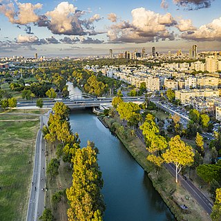
The Yarkon River, also Yarqon River or Jarkon River, is a river in central Israel. The source of the Yarkon is at Tel Afek (Antipatris), north of Petah Tikva. It flows west through Gush Dan and Tel Aviv's Yarkon Park into the Mediterranean Sea. Its Arabic name, al-Auja, means "the meandering". The Yarkon is the largest coastal river in Israel, at 27.5 km in length.

Kfar Yona is a city in the Sharon subdistrict in the Central District of Israel. It is located between the cities Netanya and Tulkarm, about 8 km east of Netanya in the central junction between Highway 6 and Highway 4. The village was established in 1932 by Maurice Fischer and was declared a local council in the year 1940. Following developments in the fields of construction, industry and, education, the local council received city status on February 11, 2014. In 2024 the city has a jurisdiction of 11,550 dunams (~11.55 km2) and a population of 29,953.

The Israel National Trail is a hiking trail that crosses the entire length of Israel, with its northern end at Kibbutz Dan in the far north of the country, extending to Eilat at the southernmost tip of Israel on the Red Sea, with a total length of 1,040 km (650 mi). The trail was inaugurated in 1995.

Modi'in-Maccabim-Re'ut is a city located in central Israel, about 35 kilometres (22 mi) southeast of Tel Aviv and 30 kilometres (19 mi) west of Jerusalem, and is connected to those two cities via Highway 443. In 2022 the population was 99,171. The population density in that year was 1,794 people per square kilometer.

Yodfat, is a moshav shitufi in northern Israel. Located in the Lower Galilee, south of Carmiel and in the vicinity of the Atzmon mountain ridge, north of the Beit Netofa Valley, it falls under the jurisdiction of Misgav Regional Council. In 2022 it had a population of 964.
Alon Shvut is an Israeli settlement in the West Bank, established in June 1970 over lands confiscated from the nearby Palestinian town of Khirbet Beit Zakariyyah. It is part of the Etzion bloc of the West Bank, administered by the Gush Etzion Regional Council, and neighbors the Israeli settlements of Kfar Etzion, Rosh Tzurim, Neve Daniel, Elazar, Bat Ayin, Migdal Oz, and Efrat. In 2022, its population was 3,046.
Oranit is an Israeli settlement and local council located in the Seam Zone of the West Bank, abutting and crossing the Green Line. It is surrounded by Horshim forest to the west, Rosh HaAyin and Kfar Qasim to the southwest, Sha'arei Tikva to the east, and Khirbet Abu Salman to the northeast. In 2022 it had a population of 9,295.

Iris haynei, the Faqqu'a Iris or Gilboa iris, is a plant species in the genus Iris, subgenus Iris and section Oncocyclus. It is a rhizomatous perennial, from the shrublands and mountainsides mostly in Israel and Palestine, on the Gilboa mountain. It has smooth, linear or lanceolate, greyish-green leaves and a long slender stem and in Spring, large, fragrant flowers in shades of deep purple, violet, purple, brownish purple or dusky lilac veining or speckling over a pale ground. It has a dark purple, black-brown, to blackish signal patch, and a beard, which is variable from dark purple, white, or dark tipped yellow. It is rarely cultivated as an ornamental plant in temperate regions, as it needs very dry conditions during the summer.

Khirbet Beit Zakariyyah is a small Palestinian village southwest of Bethlehem in the West Bank, perched on a hill that rises about 995 metres (3,264 ft) above sea level. Administratively, it is associated with the village of Artas under the Bethlehem Governorate. It is also located in between the Israeli settlements of Alon Shevut and Rosh Tzurim, both of which were built on land confiscated from the village. The village had a population of 142 in 2017.

Iris lortetii is a species in the genus Iris. It has straight grey-green leaves, a 30–50 cm tall stem, and large showy flowers in late spring or mid-summer that come in shades of pink, from white, lilac, pale lavender and grey-purple. It is veined and dotted pink or maroon. It has a signal patch that is deep maroon and a sparse and brown, purple-brown or reddish beard.

Adullam-France Park, also known as Parc de France-Adoulam, is a sprawling park of 50,000 dunams (ca. 12,350 acres) in the Central District of Israel, located south of Beit Shemesh. The park, established in 2008 for public recreation, features two major hiking and biking trails, and four major archaeological sites from the Second Temple period. It stretches between Naḥal Ha-Elah, its northernmost boundary, to Naḥal Guvrin, its southernmost boundary. To its west lies the Beit Guvrin-Beit Shemesh highway, and to its east the "green line" – now territories under joint Israeli-Palestinian Arab control – which marks its limit.

Aryeh Yitzhak King is an Israeli right-wing activist and politician who currently serves as Deputy Mayor of Jerusalem and the founder of the Israel Land Foundation. King is prominent in his activities regarding illegal Jewish settlements in East Jerusalem— which is one of the occupied Palestinian Territories.
Avi (Avraham) Sasson is an Israeli academic who serves as endowed chair of the Israel Studies Department at Ashkelon Academic College, Israel.

Rosh Pina Stream is a stream in the Upper Galilee that drains the eastern slopes of Mount Canaan. It originates on Mount Canaan, descends through the settlement of Rosh Pinna, and flows into the Jordan River. Along the stream, three springs emerge: Ein Gey-Onni, Ein Pina, and Ein Kadan. The upper part of the stream is a declared nature reserve covering an area of 273 dunams, designated on July 31, 2007.


