Round Top Branch

Last updated
Round Top Extension
1904 Cope map - Gettysburg Electric Railway.png
The Round Top Branch terminus (right, north-to-south) was south of Round Top, Pennsylvania and east of the Little Round Top summit.
Overview
Locale Adams County, Pennsylvania
Dates of operation1884 (1884)
Technical
Length2.798 mi (4.503 km) [1]


The Round Top Branch was an extension of the Gettysburg and Harrisburg Railroad from the Gettysburg borough across the Gettysburg Battlefield to Round Top, Pennsylvania. The branch ran southward from the terminus of the railroad's main line (its junction with the Hanover Junction, Hanover and Gettysburg Railroad north of Meade School), west of the school and St. Francis Xavier Cemetery, across the field of Pickett's Charge, south of Cemetery Ridge, east of Weikert Hill and Munshower Knoll, and through Round Top to a point between Little Round Top's east base and Taneytown Road. In addition to battlefield tourists, the line carried stone monoliths and statues for monuments during the battlefield's memorial association and commemorative eras and equipment, supplies and participants for Gettysburg Battlefield camps after the American Civil War (e.g., the 1884 Camp Gettysburg, 1913 Gettysburg reunion, 1918 Camp Colt and 1938 Gettysburg reunion). [2]

Contents

History

After completion of a 22 mi (35 km) initial survey of Gettysburg along Rock Creek on January 12, 1882, the Gettysburg and Harrisburg Rail Road [3] main line was instead completed into the borough along Oak Ridge with nine stations from Hunter's Run. By July 14, 1882, Ambrose E. Lehman of the State Geological Survey completed the G&HRR survey for the branch to Round Top, [4] and the HJ,H&GRR (successor to the G&HRR) [5] survey was begun by engineer Joseph S. Gitt [4] [6] for a competing Round-Top Railroad Company [7] route to Round Top; the latter was never built.

Track workers under foreman Coulson were laying rails of 80 lb (36 kg) per yard for the branch in May 1884, [8] and laborer "Blind Davy" Weikert was blinded by a premature dynamite blast. [9] The Round Top Station's warehouse was completed June 21, 1884. [10] After being surveyed in May, the branch's connection to the HJ, H&GRR was being completed on July 22, 1884 "just beyond the Cashman limestone kilns" and a siding along Fairfield Road had been completed along with a switch at the PA National Guard commissary [11] (the 1913 siding held eight carloads of ice). [12] The "dummy" Baldwin steam engine had begun excursions "to the hill" in June 1884 [10] and could carry about 40 passengers [13] (the branch's "dinky" could carry about 10). [14] The G&HRR published a Gettysburg Battlefield guidebook with 1884 images by "the great landscape photographer, Mr. Bell, of Philadelphia". [15]

By 1888 the branch's Hancock Station on the battlefield was south of The Angle near the Vermont and Tammany monuments, [16] and on a c.1900 map, a wye with crossing double spurs was depicted at Round Top Station with a benchmark at 545 ft (166 m) elevation; by 1904, the wye was no longer depicted. [17] In 1902, Camp Lawton was headquartered at The Angle with its telegraph and telephone office at the Emmitsburg Rd "junction of the steam and electric roads near the Codori buildings". [18] Through October 1914, a combination arsenal and commissary along the Round Top Branch was used for Pennsylvania National Guard camps at Gettysburg. [19] A special platform on the branch was built for 1913 Gettysburg reunion veterans to disembark directly into their camp [12] on the west side of Emmitsburg Road;[ citation needed ] after addressing the veterans, President Woodrow Wilson departed the Great Camp in his private rail car via the branch. [20]

The branch's junction was visible on a June 25 aerial photo of the 1938 Gettysburg reunion camp; [21] on May 7, 1939 a Reading Railroad train from Philadelphia carried 400 excursionists on the branch to Round Top. [22] Except for special occasions (such as a trip by Bethlehem students in 1958), [23] Reading passenger service to Gettysburg ceased in 1941 [24] and an application to abandon the Round Top Branch was made in 1942 [1] (the rails were removed and a few artifacts remain in place). The main-line junction is now located at Seminary Ridge west of the original 19th century junction, and was used by the Gettysburg Railroad (1976–1996) and the 1996-2001 Gettysburg Railway.

Route

External image
Searchtool.svg crossing of gravel Hancock Av
Map all coordinates using: OpenStreetMap
Route (north-to-south)
This list is incomplete; you can help by editing it.
Intersections & curves [17] Coordinates
Junction 39°49′57″N77°14′16″W / 39.832606°N 77.237733°W / 39.832606; -77.237733
Switch to turntable For three-engine [13] roundhouse [25]
Wye switch Behind Meade School
Stevens Run
(three crossings,
one in borough)
39°49′46″N77°14′20″W / 39.82937°N 77.238801°W / 39.82937; -77.238801

39°49′20″N77°14′32″W / 39.822214°N 77.242336°W / 39.822214; -77.242336
39°49′19″N77°14′32″W / 39.821903°N 77.242244°W / 39.821903; -77.242244

Emmitsburg Road 39°48′46″N77°14′21″W / 39.812805°N 77.23923°W / 39.812805; -77.23923
Hancock Station
Slight bend 39°48′16″N77°14′07″W / 39.804308°N 77.235169°W / 39.804308; -77.235169
Hancock Ave 39°48′12″N77°14′04″W / 39.803442°N 77.234445°W / 39.803442; -77.234445
United States Ave 39°48′09″N77°14′02″W / 39.80242°N 77.233758°W / 39.80242; -77.233758
Curve east of Weikert Hill 39°47′49″N77°13′55″W / 39.796997°N 77.231886°W / 39.796997; -77.231886
Round Top Station
Wheatfield Rd
Terminus Between ends of two rock walls

See also

Related Research Articles

<span class="mw-page-title-main">Gettysburg Battlefield</span> Site of the Battle of Gettysburg during the American Civil War

The Gettysburg Battlefield is the area of the July 1–3, 1863, military engagements of the Battle of Gettysburg within and around the borough of Gettysburg, Pennsylvania. Locations of military engagements extend from the 4-acre (1.6 ha) site of the first shot at Knoxlyn Ridge on the west of the borough, to East Cavalry Field on the east. A military engagement prior to the battle was conducted at the Gettysburg Railroad trestle over Rock Creek, which was burned on June 27.

<span class="mw-page-title-main">Rock Creek (Monocacy River tributary)</span> River in Pennsylvania, United States

Rock Creek is an 18.9-mile-long (30.4 km) tributary of the Monocacy River in south-central Pennsylvania and serves as the border between Cumberland and Mount Joy townships. Rock Creek was used by the Underground Railroad and flows near several Gettysburg Battlefield sites, including Culp's Hill, the Benner Hill artillery location, and Barlow Knoll.

<span class="mw-page-title-main">1913 Gettysburg reunion</span> American Civil War veterans reunion

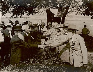
The 1913 Gettysburg reunion was a Gettysburg Battlefield encampment of American Civil War veterans for the Battle of Gettysburg's 50th anniversary. The June 29–July 4 gathering of 53,407 veterans was the largest ever Civil War veteran reunion. All honorably discharged veterans in the Grand Army of the Republic and the United Confederate Veterans were invited, and veterans from 46 of the 48 states attended, all but Nevada and Wyoming.

<span class="mw-page-title-main">Round Top, Pennsylvania</span> Unincorporated community in Pennsylvania, United States

Round Top is a populated place in Adams County in the U.S. state of Pennsylvania, near Little Round Top. It is notable for two Battle of Gettysburg hospitals, the 1884 Round Top Station, and several battlefield commemorative era attractions such as Round Top Park and the Round Top Museum. The unincorporated community lies on an elevated area of the north-south Taneytown Road with three intersections: at Blacksmith Shop Road to the northeast, Wheatfield Road, and Sachs Road.

<span class="mw-page-title-main">Gettysburg Electric Railway</span> Borough trolley serving Gettysburg Battlefield attractions

The Gettysburg Electric Railway was a borough trolley that provided summer access to Gettysburg Battlefield visitor attractions such as military engagement areas, monuments, postbellum camps, and recreation areas. Despite the 1896 Supreme Court ruling under the Takings Clause against the railway, battlefield operations continued until 1916. The trolley generating plant was leased by the Electric Light, Heat, and Power Company of Gettysburg to supply streetlights and homes until electricity was imported from Hanover.

United States v. Gettysburg Electric Ry. Co., 160 U.S. 668 (1896), was a case to prevent trolley operations on the Gettysburg Battlefield. The dispute began in August 1891 when the Gettysburg Battlefield Memorial Association's board approved attorney Samuel Swope's motion to deny trolley right-of-way along GBMA roads. Despite the 1896 US Supreme Court ruling that the railway could be seized for historic preservation, as well as earlier legislative efforts to appropriate federal acquisition funds, create a War Department commission, and form the Gettysburg National Military Park; the trolley continued operations until obsolete in 1916.

<span class="mw-page-title-main">Gettysburg and Harrisburg Railroad</span>

The Gettysburg and Harrisburg Railroad was a railway line of Pennsylvania from Hunter's Run southward to Gettysburg in the 19th century. The north junction was with the South Mountain RR, and a crossing with the Hanover Junction, Hanover and Gettysburg Railroad's westward extension was at Gettysburg. The crossing also served as a junction for westbound trains to transfer southward across the Gettysburg Battlefield via the G. & H. R. R.'s Round Top Branch to the company's Little Round Top Park.

<span class="mw-page-title-main">South Mountain Railroad (Cumberland)</span>

The South Mountain Railroad was a southcentral Pennsylvania railway line for "connecting the Pine Grove works to the Cumberland Valley R. R." and which provided mining and passenger services via a southwest section from Hunter's Run, Pennsylvania, and a northern section from Hunter's Run to the CVRR junction northeast of Carlisle. The northern section merged with the Gettysburg & Harrisburg Railroad line south from Hunter's Run to the Gettysburg Battlefield in 1891 to create the Gettysburg & Harrisburg Railway line, while the branch southwest from Hunter's Run became the Hunter's Run and Slate Belt Railroad line.

<span class="mw-page-title-main">Wheatfield Road</span>

The Wheatfield Road is a Gettysburg Battlefield crossroad from the Peach Orchard east-southeastward along the north side of The Wheatfield, north of the Valley of Death, and over the north foot of Little Round Top. In addition to modern tourist use, the road is notable for Battle of Gettysburg use and postbellum trolley use associated with the 1892-1896 US v. Gettysburg Electric Ry. case of the US Supreme Court.

<span class="mw-page-title-main">Stevens Run (Rock Creek tributary)</span>

Stevens Run is a 2.2-mile-long (3.5 km) tributary of Rock Creek in Pennsylvania in the United States.

<span class="mw-page-title-main">Tipton Station</span> Historic trolley stop in Pennsylvania

Tipton Station was a Gettysburg Battlefield trolley stop of the Gettysburg Electric Railway for passenger access to Crawford's Glen to the north, Devil's Den (west), and Tipton Park (east). The station was established during the 1894 construction of the end of the trolley line and was near the Devil's Den trolley siding, south of the trolley's Warren Avenue crossing, and northeast of the Plum Run trolley bridge. An uphill trail led southwest to Big Round Top with its 1895 Observation Tower, and the "Slaughter Pen Path and Steps" were built to Devil's Den.

<span class="mw-page-title-main">Gettysburg and Harrisburg Railway</span>

The Gettysburg and Harrisburg Railway was a Pennsylvania line from near Carlisle southward to Gettysburg operated by a subsidiary of the Reading Company. The line also included the Round Top Branch over the Gettysburg Battlefield to Round Top, Pennsylvania until c. 1942.

<span class="mw-page-title-main">Round Top Station</span> Train station in Round Top, United States

Round Top Station was the southernmost station of the Gettysburg and Harrisburg Railroad and was located west of a blacksmith shop along the Taneytown Road that was in operation in 1880.

<span class="mw-page-title-main">McPherson Ridge</span>

McPherson Ridge is a landform used for military engagements during the 1863 Battle of Gettysburg, when the I Corps of the Union Army had a headquarters on the ridge and was defeated by the Confederate division of Major General Henry Heth. The ridge has terrain above ~530 ft (160 m) and is almost entirely a federally protected area except for township portions at the southern end and along Pennsylvania Route 116, including a PennDOT facility. The northern end is a slight topographic saddle point on the west edge of Oak Ridge, and summit areas above 560 ft (170 m) include 4 on/near the Lincoln Highway, a broader summit south of the Fairfield Road, and the larger plateau at the northern saddle.

Bendersville was a Gettysburg and Harrisburg Railroad (G&H) stop east of Bendersville, Pennsylvania, with facilities of Frederick A. Asper that included a 3-story brick flour mill, grain elevator, and warehouse built in 1883. The depot was opposite the mill over the tracks.

<span class="mw-page-title-main">Western Extension (Baltimore and Harrisburg Railway)</span>

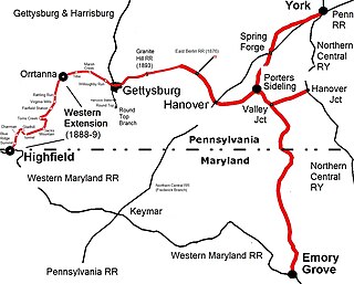
The Western Extension is a Western Maryland section of railway line between Highfield-Cascade, Maryland, and Gettysburg, Pennsylvania. The extension of the Hanover Junction, Hanover and Gettysburg Railroad westward from the Gettysburg Battlefield to Marsh Creek was completed in 1884, crossing the north-south Gettysburg and Harrisburg Railroad and its 1884 Round Top Branch in the borough The line was completed to Orr Station by June 30, 1885, then after an 1886 merger formed the Baltimore and Harrisburg Railway, the 15 mi (24 km) to the mainline at Highland near the Mason–Dixon line was completed in 1888-1889. The B&H leased their line to the Western Maryland Railway until the WM purchased it in 1917. The Western Extension used portions of the 1830s Tapeworm Railroad bed and required construction of the Jacks Mountain Tunnel south of Maria Furnace.

<span class="mw-page-title-main">Camp George G. Meade</span>

Camp George G. Meade was one of the Gettysburg Battlefield camps after the American Civil War for Pennsylvania National Guard training of the Keystone Division. The military installation's structures on the Gettysburg Battlefield were subsequently used in the battlefield's commemorative and development eras, e.g., for a WWI recruiting and Tank Corps camp, the 1913 Gettysburg reunion, and the Third Corps camp during the 1938 Gettysburg reunion.

Round Top Park was a Gettysburg Battlefield excursion park of 15 acres (6.1 ha) east of Little Round Top near the end of the Round Top Branch and owned by the Gettysburg & Harrisburg Railroad. In addition to amusements, the park provided services during the memorial association era for steamtrain and trolley tourists visiting nearby military sites of the Battle of Gettysburg.

Pine Grove Park was a South Mountain Railroad excursion park "in a grove of magnificent trees" established by Colonel Jackson C. Fuller c. 1881 It was located east of the Pine Grove Iron Works near Toland in Cumberland County, south-central Pennsylvania It was in the South Mountain Range of the northern Blue Ridge Mountains System.

References

  1. 1 2 "Seek To Abandon Round Top Branch". February 2, 1942. extending from a point 1,670 feet south of the point where it crosses the Lincoln Highway on Buford avenue to the end of the branch a distance of about 2.492 miles
  2. "Military Police on Every Night" (Google News Archive). Gettysburg Times. March 25, 1918. Retrieved 2011-01-19.
  3. "Camp Gettysburg" (Google News Archives). Gettysburg Compiler. July 29, 1884. Retrieved 2010-05-06.
  4. 1 2 "Railroad Surveys" (Google News Archive). Gettysburg Compiler. Town and County. June 14, 1882. Retrieved 2011-05-07. (1982 Out of the Past commemoration)
  5. Stewart, Dr. Henry (May 2, 1946). "Reminiscences of 70 Years in Gettysburg" (Google News Archives). Gettysburg Times . Retrieved 2011-05-06.
  6. "Out of the Past: Seventy-five Years Ago" (Google News archive). Gettysburg Times. June 17, 1957. Retrieved December 20, 2012.
  7. Gitt, Joseph S (February 9, 1884). "Baltimore and Harrisburg Railroad" (Google News Archive). Gettysburg Compiler; Adams County Railroads: Concluded (published February 19, 1884). Retrieved 2011-05-06. In August, 1882, I made surveys and a location for the purpose of extending the Gettysburg Railroad to Round-Top for excursion purposes. A charter was granted at this time, under the general railroad law, by the State Department, to the "Round-Top Railroad Company," to build a line from Gettysburg to Round-Top. The capital stock, $25,000, and A. W. Eichelberger President. The directors are Wm. Grumbine, Reuben Young, Peter Flickinger, B. M. Wirt, R. A. Eichelberger, H. A. Young, David Wills, H. D. Scott.
  8. "Out Of The Past: Fifty Years Ago" (Google News Archives). Gettysburg Times. May 12, 1958. Retrieved 2011-05-07. Track Foreman Coulson and his force of hands are laying heavy iron rails--80 pound to the yard--on the Round Top branch.
  9. "David Weikert Is Dead" (Google News Archives). Gettysburg Times. May 8, 1920. Retrieved 2011-05-07. David M. L. Weikert {{cite news}}: External link in |quote= (help)
  10. 1 2 "Local Flashes & Excursions" (Google News Archive). Gettysburg Compiler. June 24, 1884. p. 3. Retrieved 2011-02-25. Mr. Lewis A. Bushman's warehouse at Round-Top was raised on Saturday. ... The two new wells at Round-Top are both successes ... The "dummy" Baldwin made frequent trips ... taking town folks to the hill ... D. S. Fuhrman … on the Gilbert property … will sell tickets covering fifteen baths for one dollar.
  11. "Railroad Notes" (Google News Archive). Gettysburg Compiler. July 22, 1884. Retrieved 2011-05-07. The H. J., H. & G. Railroad is completing the track connecting that road with the Round-Top branch of the G. & H. The two tracks have also been joined just beyond the Cashman lime kilns, to allow the new road a more convenient route to Round-Top. … over 500 … colored Odd Fellows of Carlisle.
  12. 1 2 "First Boys In Gray Here" (Google News Archives). Adams County News. June 28, 1913. Retrieved 2011-02-07.
  13. 1 2 "Railroaders" (Google News Archives). Gettysburg Times. April 30, 1958. Retrieved 2011-05-06.
  14. Stewart, Dr. Henry (May 22, 1946). "The Tourist Trade" (Google News Archives). Gettysburg Times. Reminiscences of 70 Years in Gettysburg. Retrieved 2011-05-07.
  15. Weeks, Jim (2003). Gettysburg: Memory, Market, and an American Shrine. Princeton, New Jersey: Princeton University Press. p. 78. ISBN   9780691102719.
  16. "In The Bloody Angle" (Google News Archive). Bridgeport Morning News. September 25, 1891. Retrieved 2011-05-07. …Reading railroad station, boarded their cars and were drawn rapidly out to Hancock station on the Second corps line, a short distance from the big [Tammany] monument. (other "Hancock Station" results at Google News Archive.)
  17. 1 2 Map of the Battle Field of Gettysburg (Map). Cartography by Gettysburg National Park Commission. New York: Julius Bien & Co. Lith. 1904.{{cite map}}: External link in |cartography= (help)
  18. "Camp Lawton" (Google News Archives). The Star and Sentinel. July 2, 1927. p. 3. col. 4. Retrieved 2011-02-06. The five switches for use during the National Guard encampment by the Reading road are about completed.[p 3 col 5]
  19. "Sending Away All Guard Equipment" (Google News Archives). Adams County News. October 24, 1914. Retrieved 2011-01-22.
  20. Beitler, Lewis Eugene (editor and compiler) (December 31, 1913). Fiftieth Anniversary of the Battle of Gettysburg: Report of the Pennsylvania Commission (Google Books) (Report). Harrisburg, Pennsylvania: Wm. Stanley Bay (state printer). p. 173. Retrieved 2011-02-06.{{cite report}}: |first= has generic name (help)
  21. Cohen, Stan B (1982). Hands Across the Wall. Charleston, West Virginia: Pictorial Histories Pub. Co. p. 64.
  22. "Excursions to Bring Visitors Here Sunday". Gettysburg Times. May 6, 1939. Retrieved December 20, 2012.
  23. "450 Bethlehem Hi Students On 'Field". Gettysburg Times. May 2, 1958. Retrieved December 20, 2012.
  24. "The Gettysburg and Harrisburg Railroad Depot". HMdb.org. Retrieved December 20, 2012.
  25. "Dan Skelly" (Google News Archives). Gettysburg Times. April 30, 1969. Retrieved 2011-05-06.