
The Maryland Transit Administration (MTA) is a state-operated mass transit administration in Maryland, and is part of the Maryland Department of Transportation. The MTA operates a comprehensive transit system throughout the Baltimore-Washington Metropolitan Area. There are 80 bus lines serving Baltimore's public transportation needs, along with other services that include the Light Rail, Metro Subway, and MARC Train. With nearly half the population of Baltimore residents lacking access to a car, the MTA is an important part of the regional transit picture. The system has many connections to other transit agencies of Central Maryland, Washington, D.C., Northern Virginia, and south-central Pennsylvania : WMATA, Charm City Circulator, Regional Transportation Agency of Central Maryland, Annapolis Transit, Rabbit Transit, Ride-On, and TransIT.

Light RailLink is a light rail system serving Baltimore, Maryland, United States, as well as its surrounding suburbs. It is operated by the Maryland Transit Administration. In downtown Baltimore, it uses city streets. Outside the central portions of the city, the line is built on private rights-of-way, mostly from the defunct Northern Central Railway, Baltimore and Annapolis Railroad and Washington, Baltimore and Annapolis Electric Railway.

LocalLink 93 is a bus route operated by the Maryland Transit Administration in the suburbs of Baltimore. The line currently runs from the Lutherville Light Rail Stop to International Circle near Hunt Valley Town Center, serving the Timonium and Cockeysville areas.
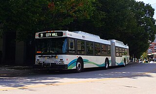
Route 91 is a bus route operated by the Maryland Transit Administration in Baltimore. The line currently runs from Sinai Hospital to City Hall, serving the communities of Pimlico, Arlington, Walbrook, and Bolton Hill, Coppin State College and the corridors of Garrison Boulevard and Eutaw Place. The line has the second-highest farebox recovery rate of all MTA bus lines.

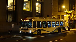
Route 14 is a bus route operated by the Maryland Transit Administration between Baltimore and Annapolis, Maryland. At most times, the line operates from the Patapsco Light Rail Stop in southern Baltimore with short turns at Jumper's Hole in Pasadena. The bus route, one of the longest local routes operated by MTA, is the successor to the Baltimore and Annapolis Railroad interurban, and mainly operates along the parallel Ritchie Highway, serving Brooklyn Park, Glen Burnie, Pasadena, and Severna Park. When the Light Rail is not running, Route 14 runs all the way to downtown Baltimore, mostly along Hanover Street.

LocalLink 75 is a bus route operated by the Maryland Transit Administration in Baltimore and its suburbs. The line currently runs from the Patapsco Light Rail Stop to Parkway Center in Anne Arundel County, via BWI Airport and Arundel Mills. Weekend trips and some weekday trips on this line terminate at Arundel Mills. The line operates between BWI Airport and downtown Baltimore during hours when the light rail is not operating.
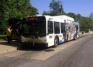
Route 23 is a bus route operated by the Maryland Transit Administration in Baltimore and its suburbs. The line currently runs from the Wal-Mart parking lot in Catonsville, Maryland east through downtown Baltimore to the Fox Ridge community in Essex, serving the corridors of Edmondson Avenue on the west side and Eastern Avenue on the east, and the communities of Edmondson Village, Allendale, Rosemont, Patterson Park, and Eastpoint, and is one of the most heavily used bus routes operated by the MTA.

CityLink Red is a citylink bus route operated by the Maryland Transit Administration in Baltimore and its suburbs. The line currently runs from the University of Maryland Transit Center to the Lutherville Light Rail Stop along the corridors of York Road and Greenmount Avenue, and is one of the most heavily used MTA bus lines. The CityLink Red bus replaced Route 8 bus route due to BaltimoreLink, and is the successor to the 8 Towson and 7 Govanstown streetcar lines.
LocalLink 95 is a bus route operated by the Maryland Transit Administration in Baltimore. The line currently runs from the intersection of Roland Avenue and Lake Avenue in Roland Park south to the Inner Harbor via Roland Avenue, University Parkway, Charles Street and St. Paul Street.

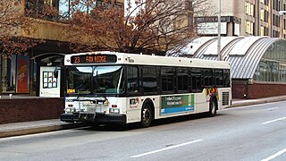
Route 54 is a bus route operated by the Maryland Transit Administration in Baltimore and its suburbs. The route was formerly known as Route 19 prior to 2017. The line currently runs from the State Center Metro Subway Station to the intersection of Harford Road and Northern Parkway. From there it splits into two branches. About one half of buses continue operating along Harford Road to the Carney Park-and-Ride just north of the I-695 interchange, and the other half to the intersection of Goucher Boulevard and Taylor Avenue in Towson via Northern, McLean Boulevard, Hillsway, and Taylor. The line serves the communities of Montebello, Hamilton, and Parkville.
Route 5 is a bus route operated by the Maryland Transit Administration in Baltimore. The line currently runs from Cedonia in northeast Baltimore to the Mondawmin Metro Subway Station. The line has two alternating routes in East Baltimore: one via the area of Johns Hopkins Hospital, and one via a one-way pair of streets a few blocks north. A small number of trips also operate to/from Federal Street or Lanvale & Patterson Park.

Route 35 is a bus route operated by the Maryland Transit Administration in Baltimore and its suburbs. The line currently runs from White Marsh Mall to UMBC through the city of Baltimore, with selected peak hour trips to Landsdowne. The line serves the Essex campus of the Community College of Baltimore County, the corridors of Philadelphia Road, Pulaski Highway, Monument Street, and Wilkens Avenue, the communities of Rosedale, East Baltimore, Southwest Baltimore, Elm Ridge, and Arbutus, and several Metro stations.

Patapsco station is a Baltimore Light Rail station in Halethorpe, Maryland. The stop is located along Patapsco Avenue from which its name is derived. The station serves as a hub for several MTA bus routes. Patapsco was the final stop along the line for a period from September 1992 until April 1993, when the line was extended to Linthicum.

Route 77 is a bus route operated by the Maryland Transit Administration in the suburbs of Baltimore. The line currently runs from the Old Court Metro Subway Station in Pikesville, Maryland to the Patapsco Light Rail Stop, and serves Randallstown, Windsor Mill, Woodlawn, Catonsville, Arbutus, Halethorpe, and Lansdowne, and the campuses of UMBC and CCBC Catonsville.

Route 51 is a bus route operated by the Maryland Transit Administration in Baltimore and its suburbs. The line currently runs from the Rogers Avenue Metro Subway Station to the Patapsco Light Rail Stop, serving the communities of Arlington, Ashburton, Mondawmin, Rosemont, Baltimore, Cherry Hill, and Mt. Winans, and the suburb of Baltimore Highlands.

LocalLink 29 is a bus route operated by the Maryland Transit Administration in Baltimore. The line currently runs from the Mondawmin Metro Subway Station in Northwest Baltimore to Brooklyn Homes in South Baltimore through the communities of Rosemont and the corridors of Hilton Street, Caton Avenue, and Patapsco Avenue. During peak hours, selected trips operate via Violetville Industrial Park.
Route 29 is a bus route operated by the Maryland Transit Administration in Baltimore. The line currently operates weekdays and Saturdays in a circular fashion, linking the Cherry Hill Light Rail Stop to the Cherry Hill community. Two other MTA bus lines, Routes 27 and 51, also serve the Cherry Hill area.
LocalLink 85 is a bus route that operates in Baltimore and its suburbs. All trips operate from the Penn-North Metro Subway Station in Baltimore City to the Milford Mill Metro Subway Station in Pikesville. The route, which started operating on August 24, 2008, is a combination of the most recent versions of the former routes M-3 and M-8, which had been operating since 1984 and 1987 respectively. Prior to these dates, the routes had been served by other buses and streetcars.

Hawkins Point is a neighborhood in the South District of Baltimore, located at the southern tip of the city between Curtis Bay (north) and the Anne Arundel County line (south) and Thoms Cove (east). Its land area covers 2.6 square miles (6.7 km2), and it had a population of 24 people according to the 2020 U.S. Census. The neighborhood is predominantly industrial.
