
Mount Whitney is the highest mountain in the contiguous United States, with an elevation of 14,505 feet (4,421 m). It is in East–Central California, in the Sierra Nevada, on the boundary between California's Inyo and Tulare counties, and 84.6 miles (136.2 km) west-northwest of North America's lowest topographic point, Badwater Basin in Death Valley National Park, at 282 ft (86 m) below sea level. The mountain's west slope is in Sequoia National Park and the summit is the southern terminus of the John Muir Trail, which runs 211.9 mi (341.0 km) from Happy Isles in Yosemite Valley. The eastern slopes are in Inyo National Forest in Inyo County. Mount Whitney is ranked 18th by topographic isolation.

Mount Lyell is the highest point in Yosemite National Park, at 13,114 feet (3,997 m). It is located at the southeast end of the Cathedral Range, 1+1⁄4 miles northwest of Rodgers Peak. The peak as well as nearby Lyell Canyon is named after Charles Lyell, a well-known 19th century geologist. The peak had one of the last remaining glaciers in Yosemite, Lyell Glacier. The Lyell Glacier is currently considered to be a permanent ice field, not a living glacier. Mount Lyell divides the Tuolumne River watershed to the north, the Merced to the west, and the Rush Creek drainage in the Mono Lake Basin to the southeast.

Mount Williamson, at an elevation of 14,379 feet (4,383 m), is the second-highest mountain in both the Sierra Nevada range and the state of California, and the sixth-highest peak in the contiguous United States.

Split Mountain is a fourteener in the Sierra Nevada of the U.S. state of California, near the southeast end of the Palisades group of peaks. It is the only fourteener in the watershed of the South Fork Kings River, and it rises to 14,064 feet (4,287 m), making it the eighth-highest peak in the state.

Mount Tyndall is a peak in the Mount Whitney region of the Sierra Nevada in the U.S. state of California. At 14,025 feet (4,275 m), it is the tenth highest peak in the state. The mountain was named in honor of the Irish scientist and mountaineer, John Tyndall.

Mount Agassiz, at 13,899 feet (4,236 m), is one of the 20 highest peaks of California. It is the northernmost and easiest to climb of the major Palisades summits. This peak is not to be confused with the 9,967-foot (3,038 m) peak by the same name in Desolation Wilderness, also in the California Sierra.

Mount Winchell, a thirteener, is among the thirty highest peaks of California. It is in the Palisades region of the Sierra Nevada, on the Sierra Crest between Mount Agassiz and Thunderbolt Peak.

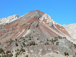
Mount Morgan is a mountain located in northwestern Inyo County, California, in the John Muir Wilderness of the Inyo National Forest.

Mount Keith is a mountain on the crest of California's Sierra Nevada, between Mount Bradley to the north, and Junction Peak to the southwest. Its north and west facing slopes feed the Kings River watershed by way of Bubbs Creek, and its east and south slopes feed the Owens River via Shepherd Creek. By the same dividing line, Keith stands on the boundary of Kings Canyon National Park to the northwest, and the John Muir Wilderness to the southeast. It is a thirteener, a mountain which has a height over 13000 feet.

Mount Gould is a thirteener on the Sierra crest, just north of the Kearsarge Pass.

Mount Farquhar, or Mount Francis Farquhar, is a peak in Kings Canyon National Park. It is named in for Francis P. Farquhar, a conservationist who played a key role in creating the park.

Rock Creek is a stream that flows from the high Eastern Sierra Nevada to the Owens River in Mono County of eastern California. The upper watershed is in the John Muir Wilderness of the Sierra and Inyo National Forests.

Mount Dade is a 13,606 feet (4,147 m) mountain located on the crest of the Sierra Nevada mountain range in northern California, United States. It is situated in the John Muir Wilderness on the boundary between Sierra National Forest and Inyo National Forest, and along the common border of Fresno County with Inyo County. It is one mile west of Dade Lake, and approximately 22 miles (35 km) west of the community of Bishop. Nearby neighbors include Mount Abbot, 0.4 mile to the northwest, and Bear Creek Spire 1.2 mile to the southeast. The USGS probably named this peak during a 1907–09 survey, and the first ascent was made August 19, 1911, by Liston and McKeen, of Fresno.

Red and White Mountain is a remote 12,816-foot-elevation mountain summit located on the crest of the Sierra Nevada mountain range in northern California, United States. It is situated in the John Muir Wilderness on the shared boundary of Sierra National Forest with Inyo National Forest, and along the common border of Fresno County with Mono County. It is eight miles northeast of Lake Thomas A Edison, and approximately 13 miles (21 km) southeast of the community of Mammoth Lakes. The nearest higher neighbor is Red Slate Mountain, 2 miles (3.2 km) to the north-northwest.

Recess Peak is a 12,813-foot-elevation mountain summit located west of the crest of the Sierra Nevada mountain range in Fresno County of northern California, United States. It is situated on Mono Divide in the John Muir Wilderness, on land managed by Sierra National Forest, and approximately six miles east of Lake Thomas A Edison. The nearest higher neighbor is Mount Hilgard, 2.2 miles (3.5 km) to the southeast. The John Muir Trail follows Bear Creek below the western slope of this remote peak. The summit is surrounded by arêtes and cirques, which were formed by glaciers in the past, most recently ending 13,000 years ago in the late Pleistocene.

Mount McDuffie is a 13,291-foot-elevation (4,051-meter) mountain summit located west of the crest of the Sierra Nevada mountain range, in Fresno County of central California, United States. This peak is situated in northern Kings Canyon National Park, 1.9 miles (3.1 km) northwest of The Citadel, and two miles south of Black Giant, which is the nearest higher neighbor. McDuffie ranks as the 93rd highest summit in California, and the second-highest point on Black Divide. Topographic relief is significant as it rises nearly 4,900 feet above Le Conte Canyon in approximately 2.5 miles. An approach to this remote peak is made possible via the John Muir Trail.

Mount Baldwin is a 12,614-foot-elevation (3,845-meter) mountain summit located in the Sierra Nevada mountain range in Mono County of northern California, United States. It is situated in the John Muir Wilderness on land managed by Inyo National Forest. It is four miles north of Red and White Mountain, and approximately 10.5 miles (16.9 km) southeast of the community of Mammoth Lakes. The nearest higher neighbor is Red Slate Mountain, 2 miles (3.2 km) to the south-southwest. Baldwin ranks as the 257th highest summit in California. Topographic relief is significant as the east aspect rises 3,775 feet above McGee Canyon in 1.5 mile. The first ascent of the summit was made July 2, 1928, by Norman Clyde, who is credited with 130 first ascents, most of which were in the Sierra Nevada.

Mount Gilbert is a 13,106-foot (3,995 m) mountain located on the crest of the Sierra Nevada range in California, United States. It is situated on the shared boundary of Kings Canyon National Park and John Muir Wilderness, and along the common border of Fresno County and Inyo County. It is 18 miles (29 km) west of the community of Big Pine, 0.8 mile northwest of Mount Johnson, and one mile southeast of Mount Thompson, which is its nearest higher neighbor. Mount Gilbert ranks as the 127th-highest summit in California. Topographic relief is significant as the south aspect rises 3,900 feet (1,189 m) above LeConte Canyon in less than two miles, and the northern aspect rises 3,340 feet above South Lake in 2.5 miles.

Mount Izaak Walton is a 12,077-foot-elevation (3,681 meter) mountain summit located in the Sierra Nevada mountain range in Fresno County of northern California, United States. It is situated in the John Muir Wilderness, on land managed by Sierra National Forest. Mount Izaak Walton ranks as the 404th-highest summit in California. Topographic relief is significant as the northwest aspect rises 1,800 feet above Izaak Walton Lake in approximately one mile. It is six miles northeast of Lake Thomas A Edison, and approximately 14 miles (23 km) south-southeast of the community of Mammoth Lakes. The peak is set on Silver Divide, so precipitation runoff from the north side of this mountain drains into Fish Creek which is a tributary of the San Joaquin River, and from the south slope to Mono Creek, also a tributary of the San Joaquin.
Herlihy Peak is an 11,758-foot-elevation (3,584 meter) mountain summit located in the Sierra Nevada mountain range in Mono County of northern California, United States. It is situated approximately four miles south of the community of Mammoth Lakes, in the John Muir Wilderness, on land managed by Inyo National Forest. Herlihy Peak is positioned midway between landmarks Crystal Crag and Bloody Mountain. Topographic relief is significant as the east aspect rises 2,060 feet above Valentine Lake in approximately one mile, and the west aspect rises 1,844 feet above Skelton Lake in 0.8 mile. Precipitation runoff from the peak drains to Mammoth Creek.

