The SWP found cisterns cut in the rock and a well.[4] Dauphin described the place as being an ancient village on a hill slope, with traces of ancient remains, including cisterns and caves carved into rock.[5]
In the census of 1596, the village was located in the nahiya of Sara in the liwa of Lajjun. It had a population of 12 households, all Muslim. The villagers paid a fixed tax-rate of 25% on agricultural products, including wheat, barley, summer crops, olive trees, goats and beehives, in addition to occasional revenues; a total of 9,000 akçe.[8]
The Dutch lieutenant van der Velde travelled in the area in 1851–2. He noted that Scottish missionaries in 1839 had found many old wells and other old remains in the area. He also described the village (called Rumuni) as being small, and identified it with ancient Hadad-rimmon (see Zechariah 12:11).[9] French explorer Victor Guérin visited the village in 1863 and 1870, and described it as being reduced to "twenty miserable dwellings". He did not notice any traces of antiquity, except for a few cisterns in the rock and a working well. Guérin agreed that the village was Hadad-Rimon, but disagreed with Jeromes assertion that Hadad-Rimon was identical with Maximianopolis.[10]
In 1870/1871 (1288 AH), an Ottoman census listed the village in the nahiya of Shafa al-Gharby.[11]
A small village of mud and stone, near the foot of the hills, with wells to the west and olives below. This village seems to mark the site of Maximianopolis, a town 20 Roman miles from Caesarea and 10 miles from Jezreel (Zer'in), the ancient name of Maximianopolis being, according to Jerome, "Hadad Rimmon".[12]
In the 1945 statistics, the population of Rummana (including Khirbat Salim) was 880 Muslims[15] while the total land area was 21,676 dunams, according to an official land and population survey.[16] Of this, 2,876 dunams were allocated for plantations and irrigable land, 10,507 for cereals,[17] while 27 dunams were classified as built-up areas.[18]
↑ Government of Palestine, Department of Statistics, 1945, p. 16
↑ Government of Palestine, Department of Statistics. Village Statistics, April, 1945. Quoted in Hadawi, 1970, p. 55
↑ Government of Palestine, Department of Statistics. Village Statistics, April, 1945. Quoted in Hadawi, 1970, p. 99
↑ Government of Palestine, Department of Statistics. Village Statistics, April, 1945. Quoted in Hadawi, 1970, p. 149
↑ Government of Jordan, Department of Statistics, 1964, p. 25
↑ Grossman, D. (1986). "Oscillations in the Rural Settlement of Samaria and Judaea in the Ottoman Period". in Shomron studies. Dar, S., Safrai, S., (eds). Tel Aviv: Hakibbutz Hameuchad Publishing House. p. 349
Burqin is a Palestinian town in the northern West Bank located 5 km west of Jenin. According to the Palestinian Central Bureau of Statistics (PCBS) census, its population was 5,685 in 2007 and 7,126 in 2017. The majority of Burqin's residents are Muslims, and 20 Christian families live in the town. The Byzantine-era Burqin Church or St. George's Church is one of the oldest churches in the world.
Deir Ghazaleh is a Palestinian village in the northern West Bank, located nine kilometers northeast of Jenin in the Jenin Governorate. According to the Palestinian Central Bureau of Statistics, Deir Ghazaleh had a population of over 850 inhabitants in mid-year 2006 and 1,129 in 2017, mostly Muslims with a small Christian minority.
Sanur is a Palestinian village located 26 kilometres (16 mi) southwest of Jenin, in the Jenin Governorate of the State of Palestine. According to the Palestinian Central Bureau of Statistics, Sanur had a population of 4,067 in 2007 and 5,036 in 2017. During the late Ottoman era, Sanur served as a fortified village of the Jarrar family and played a key role in limiting the centralized power of the Ottoman sultanate, the Ottoman governors of Damascus and Acre and the Ottoman-aligned Tuqan family of Nablus from exerting direct authority over the rural highlands of Jabal Nablus.
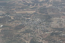
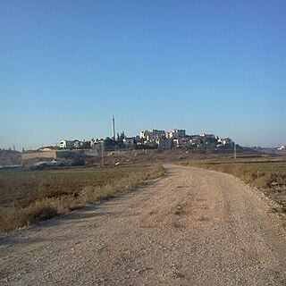
Rumana is an Arab village in northern Israel. Located near Nazareth, it falls under the jurisdiction of al-Batuf Regional Council. In 2022 its population was 1,276.
Ajjah is a Palestinian village in the Jenin Governorate in the northern West Bank, located 19 kilometers southwest of Jenin. According to the Palestinian Central Bureau of Statistics, the village had a population of 6,162 in 2017.
Araqah is a Palestinian village in the Jenin Governorate in the Northern area of the West Bank, located 15 kilometers West of Jenin. According to the Palestinian Central Bureau of Statistics, the village had a population of 2,667 inhabitants in 2017.
Sir is a Palestinian town in the Jenin Governorate of Palestine, in the West Bank, located 18 kilometers south of Jenin. According to the Palestinian Central Bureau of Statistics, the town had a population of 769 inhabitants in mid-year 2006 and 857 by 2017.
Majdal Bani Fadil is a Palestinian town in the Nablus Governorate of the State of Palestine in the northern West Bank, located 23 kilometers (14 mi) southeast of Nablus. According to the Palestinian Central Bureau of Statistics (PCBS), the town had a population of 2,907 inhabitants in 2017.
Umm al-Tut is a Palestinian village 6 km southeast of the city of Jenin in the northern West Bank. According to the Palestinian Central Bureau of Statistics, the town had a population of 1003 inhabitants in mid-year 2006 and 1,194 by 2017.
Jalqamus is a Palestinian village in the West Bank, located 10 km southeast of the city of Jenin in the northern West Bank. According to the Palestinian Central Bureau of Statistics, the town had a population of 1,867 inhabitants in mid-year 2006 and 2,624 by 2017.
Deir Abu Da'if is a Palestinian village in the West Bank, located 6 km east of the city of Jenin in the northern West Bank. According to the Palestinian Central Bureau of Statistics, the town had a population of 5,293 inhabitants in mid-year 2006 and 7,045 in 2017.
Ti'inik, also transliterated Ti’innik, or Ta'anakh/Taanach, is a Palestinian village, located 13 km northwest of the city of Jenin in the northern West Bank.
Zububa is the northernmost Palestinian village in the West Bank, located 10 km Northwest of the city of Jenin in the northern West Bank. According to the Palestinian Central Bureau of Statistics, the town had an estimated population of 2322 inhabitants in.
Jalamah or Jalameh is a Palestinian village in the West Bank, located 5 km north of the city of Jenin in the northern West Bank. According to the Palestinian Central Bureau of Statistics, the town had a population of 2,304 inhabitants in mid-year 2006 and 2,268 in 2017.
’Arrana is a Palestinian village in the Jenin Governorate, located 4 kilometers Northeast of Jenin, in the northern West Bank. According to the Palestinian Central Bureau of Statistics, the village had a population of 2,418 inhabitants in 2017.
Al-Judeida is a Palestinian village in the Jenin Governorate in the western area of the West Bank, located 14 kilometres (9 mi) south of Jenin. According to the Palestinian Central Bureau of Statistics, the town had a population of 4,738 in the 2007 census and 5,950 by 2017.
Kafr Qud is a Palestinian village in the Jenin Governorate in the northern West Bank, located west of Jenin. According to the Palestinian Central Bureau of Statistics (PCBS) census, it had a population of 1,143 in 2007 and 1,553 in 2017.
Rama is a Palestinian village in the Jenin Governorate.
Kufeir is a Palestinian village in the Jenin Governorate.
Jarba is a Palestinian village in the Jenin Governorate.
This page is based on this Wikipedia article Text is available under the CC BY-SA 4.0 license; additional terms may apply. Images, videos and audio are available under their respective licenses.


