al-Attara | |
---|---|
Arabic transcription(s) | |
• Arabic | العطارة |
• Latin | al-Attara (official) al-’Attara (unofficial) |
Location of al-Attara within Palestine | |
Coordinates: 32°19′35″N35°09′42″E / 32.32639°N 35.16167°E | |
Palestine grid | 168/192 |
State | State of Palestine |
Governorate | Jenin |
Government | |
• Type | Village council |
Population (2017) [1] | |
• Total | 1,244 |
Name meaning | 'Attara, personal name, compare Hebrew: עטרות [2] |
Al-Attara (Arabic : العطارة) is a Palestinian village in the Jenin Governorate of Palestine, in the northwestern area of the West Bank, located 15 kilometers southwest of Jenin. According to the Palestinian Central Bureau of Statistics, the village had a population of 1,072 inhabitants in mid-year 2006 and 1,244 by 2017. [1] [3]
Pottery sherds from the late Roman, Byzantine and early Islamic periods have been found here. [4]
According to SWP: "This place is mentioned in the Onomasticon (s. v. Atharoth) as a city of Ephraim, north of Sebaste, and 4 miles from it. The distance is exact." [5]
In Crusader sources it was called Lathara. [4]
In 1140, Ussama, a Moslem traveller, mentioned Al-Attara together with nearby Silat ad-Dhahr. [4]
In 1178, it was attacked by Bedouin, but withstood the attack. [4]
Al-Attara, like all of Palestine, was incorporated into the Ottoman Empire in 1517. About 10% of the pottery sherds found in the village date back to this period. [4] In the 1596 Ottoman tax registers, Al-Attara was listed as an entirely Muslim village called 'Attara, and had a population of 12 families and 2 bachelors. It was located in the nahiya of Jabal Sami in the liwa of Nablus. The inhabitants paid a fixed tax rate of 33,3% on agricultural products, including wheat, barley, summer crops, olive trees, and goats and/or beehives, in addition to occasional revenues and a tax on people from the Nablus area, a total of 5,000 akçe. [6]
A fortress, dating from the 16th—17th century, is visible in the centre of the village. [4]
In 1870, Victor Guérin noted it as a poor village, but one which had succeeded an ancient place. [7]
In 1870/1871 (1288 AH), an Ottoman census listed the village in the nahiya (sub-district) of al-Sha'rawiyya al-Gharbiyya. [8]
In 1882, the PEF's Survey of Western Palestine (SWP) described Al-Attara as "A small stone village on a spur of mountain, with a few olives and a well on the west." [5]
In the 1922 census of Palestine conducted by the British Mandate authorities, Al-Attara had a population of 164 Muslims, [9] increasing in the 1931 census to 193 Muslims, in 51 houses. [10]
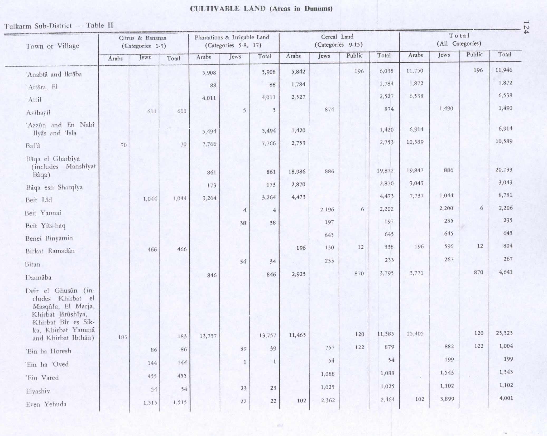
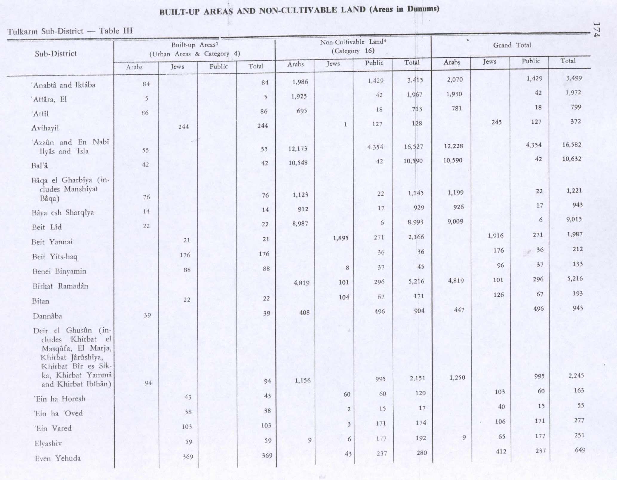
In the 1945 statistics, the population of Al-Attara was 250 Muslims, [11] with 3,844 dunams of land according to an official land and population survey. [12] Of this, 88 dunams were plantations and irrigable land, 1,784 were used for cereals, [13] while 5 dunams were built-up (urban) land. [14]
After the 1948 Arab–Israeli War and the 1949 Armistice Agreements, Al-Attara came under Jordanian rule.
The Jordanian census of 1961 found 388 inhabitants in Al-Attara. [15]
Since the Six-Day War in 1967, Al-Attara has been under Israeli occupation.
Qabatiya is a city in Jenin Governorate, West Bank, Palestine. According to the Palestinian Central Bureau of Statistics (PCBS) census, the town had a population of 19,197 in 2007 and 24,439 by 2017.
Ya'bad is a Palestinian town in the northern West Bank, 20 kilometers west of Jenin, in the Jenin Governorate of Palestine. It is a major agricultural town, with most of its land covered with olive groves and grain fields. According to the Palestinian Central Bureau of Statistics, the town had a population of 13,640 in 2007 and 16,012 in 2017. Its mayor is Samer Abu Baker who was elected in 2005. The Israeli settlement of Mevo Dotan is built on Ya'bad's land.
Burqin is a Palestinian town in the northern West Bank located 5 km west of Jenin. According to the Palestinian Central Bureau of Statistics (PCBS) census, its population was 5,685 in 2007 and 7,126 in 2017. The majority of Burqin's residents are Muslims, and 20 Christian families live in the town. The Byzantine-era Burqin Church or St. George's Church is one of the oldest churches in the world.
'Aqqaba is a Palestinian town located on a slope in the Jordan Valley in the northern West Bank, 15 kilometers northeast of Jenin in the Tubas Governorate of the State of Palestine. According to the Palestinian Central Bureau of Statistics (PCBS), the town had a population of 8,239 inhabitants in the 2017 census.
Bizzariya is a Palestinian village in the northern West Bank, located 13.3 kilometers northwest of Nablus at the northernmost point of the Nablus Governorate. It is situated in a valley, having an altitude of 460 meters above sea level. According to the Palestinian Central Bureau of Statistics, Bizzariya had a population of over 2,252 inhabitants in 2007 and 2,794 by 2017.
Kafr Rumman is a Palestinian town in the Tulkarm Governorate in the eastern West Bank, located 11 kilometers East of Tulkarm. According to the Palestinian Central Bureau of Statistics, Kafr Rumman had a population of approximately 869 inhabitants in mid-year 2007.
Ajjah is a Palestinian village in the Jenin Governorate of the State of Palestine, in the northern West Bank, located 19 kilometers southwest of Jenin. According to the Palestinian Central Bureau of Statistics, the village had a population of 6,162 in 2017.
Sir is a Palestinian town in the Jenin Governorate of Palestine, in the West Bank, located 18 kilometers south of Jenin. According to the Palestinian Central Bureau of Statistics, the town had a population of 769 inhabitants in mid-year 2006 and 857 by 2017.
Kafr Ra'i is a Palestinian town in the Jenin Governorate of the State of Palestine, in the northern West Bank, located 22 kilometers southwest of the city of Jenin. According to the Palestinian Central Bureau of Statistics, Kafr Ra'i had a population of 7,364 in the 2007 census and 8,471 by 2017.
Kufeirit is a Palestinian village in the West Bank, located 16 km west of the city of Jenin in the northern West Bank. According to the Palestinian Central Bureau of Statistics, the town had a population of 2,446 inhabitants in mid-year 2006 and 3,068 by 2017.
Kafr Dan is a Palestinian village in the Jenin Governorate, located 8 km northwest of Jenin in the northern West Bank. According to the Palestinian Central Bureau of Statistics (PCBS) census, the town had a population of 5,148 in 2007 and 6,591 in 2017.
Rummanah is a Palestinian village in the Jenin Governorate of Palestine, located 17 kilometers (11 mi) northwest of the city of Jenin in the northern West Bank. According to the Palestinian Central Bureau of Statistics (PCBS), the town had a population of 3,372 inhabitants in mid-year 2006.
Mirka is a Palestinian village in the West Bank, located 12 km (7.5 mi) Southwest of the city of Jenin in the northern West Bank. According to the Palestinian Central Bureau of Statistics, the town had a population of 1,555 inhabitants in mid-year 2006 and 2,203 by 2017.
Al-Judeida is a Palestinian village in the Jenin Governorate in the western area of the West Bank, located 14 kilometres (9 mi) south of Jenin. According to the Palestinian Central Bureau of Statistics, the town had a population of 4,738 in the 2007 census and 5,950 by 2017.
Kafr Qud is a Palestinian village in the Jenin Governorate in the northern West Bank, located west of Jenin. According to the Palestinian Central Bureau of Statistics (PCBS) census, it had a population of 1,143 in 2007 and 1,553 in 2017.
Az-Zawiya is a Palestinian village in the Jenin Governorate in the northern West Bank, located south of Jenin. According to the Palestinian Central Bureau of Statistics (PCBS) census, the village had a population of 770 in 2007 and 1,006 by 2017.
Siris is a Palestinian town in the Jenin Governorate in the western area of the West Bank, located 32 kilometers south of Jenin. According to the Palestinian Central Bureau of Statistics, the town had a population of 5400 inhabitants in mid-year 2006 and 6,020 by 2017. Siris has an area of about 12,495 dunums, including 2,500 dunums of state land, about 7,500 dunums planted with olive trees, about 1,500 dunums of land, and the rest used for construction.
Zibda is a Palestinian village in the Jenin Governorate.
Kufeir is a Palestinian village in the Jenin Governorate.
Jarba is a Palestinian village in the Jenin Governorate.