List of cities in Palestine

Last updated
Map of cities in Palestine West Bank & Gaza Map 2007 (Settlements).png
Map of cities in Palestine

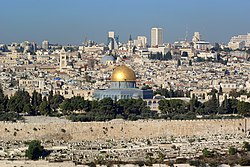
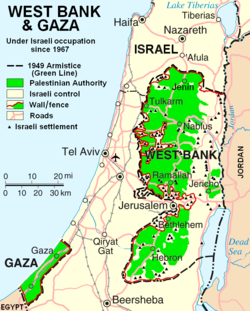
The following is the list of cities in Palestine. After the 1995 Interim Agreements, the Palestinian National Authority, which was renamed to the State of Palestine in 2013, took control of civil affairs in the West Bank Palestinian enclaves, designated Areas A and B, where most Palestinian population centers are located (and excluding those within the municipal borders of East Jerusalem). Israel Defense Forces are responsible for security in Area B in the West Bank and have full control over localities in Area C.

Contents

Following the 2007 rift between the main two Palestinian factions Fatah and Hamas, the PA has been split with the former dominating the Palestinian government in the West Bank and the latter controlling the Gaza Strip.

Local regulations

The Local Government Ministry of the Palestinian National Authority is responsible for granting a town with city or municipality status. However, there is no specific guidelines for a particular locality to achieve the status of Palestinian city. It is mostly judged on the population reaching above 20,000. The Palestinian Central Bureau of Statistics (PCBS) took its latest official census in 2007. [1]

List of cities

The largest city in the Gaza Strip and all of Palestine was Gaza City prior to the Israel-Hamas War, and the largest cities in the West Bank are East Jerusalem and Hebron. Some cities form agglomerations with other towns or cities, such as the Bethlehem metropolitan area with Beit Jala and Beit Sahour. Ramallah and al-Bireh also form an agglomeration and are often considered a single city.[ citation needed ]

  Cities in the West Bank
  Cities in the Gaza Strip
Jerusalem Jerusalem Dome of the rock BW 14.JPG
Jerusalem
Gaza City Gaza City.JPG
Gaza City
Hebron (al-Khalil) Hebron172.JPG
Hebron (al-Khalil)
Nablus Nablus panorama-cropped.jpg
Nablus
Jenin Jenin-new.jpg
Jenin
Ramallah PS-Ramallah view.JPG
Ramallah
Common Name Arabic Name Governorate Jurisdiction Population (2007 census) [2] Population (2015 estimate) [3]
Abasan al-Kabira عبسان الكبيرة Khan Yunis Area A18,41323,198
Abu Dis أبو ديس Jerusalem Area B10,78212,385
Bani Na'im بني نعيم Hebron Area A, Area B20,08425,698
Bani Suheila بني سهيلا Khan Yunis Area A31,70339,941
Beit Hanoun بيت حانون North Gaza Area A38,04751,073
Beit Jala بيت جالا Bethlehem Area A, Area C [4] 11,75814,419
Beit Lahia بيت لاهيا North Gaza Area A64,45786,526
Beit Sahour بيت ساحور Bethlehem Area A15,36718,165
Beit Ummar بيت اُمّر Hebron Area B13,54817,335
Beitunia بيتونيا Ramallah and al-Bireh Area A39,76134,592
Bethlehem (Beit Lahm)بيت لحم Bethlehem Area A35,26640,983
al-Bireh البيرة Ramallah and al-Bireh Area A58,20267,540
Deir al-Balah دير البلح Deir al-Balah Area A54,43970,045
ad-Dhahiriya الظاهرية Hebron Area A28,77636,820
Dura دوره Hebron Area A28,26836,170
Gaza City (Ghazzah)غزة Gaza Area A649,221766,331
Halhul حلحول Hebron Area A22,12828,313
Hebron (al-Khalil)الخليل Hebron Area A, Area B, Area C263,146308,750
Idhna إذنا Hebron Area B19,01224,326
Jabalia جباليا North Gaza Area A122,998165,110
Jenin جنين Jenin Area A99,004115,305
Jericho (Ariha)أريحا Jericho Area A18,34622,609
Jerusalem القُدس Jerusalem Area C747,600857,800
Khan Yunis خان يونس Khan Yunis Area A142,637179,701
Nablus نابلس Nablus Area A216,132239,772
Qabatiya قباطية Jenin Area A36,19740,282
Qalqilya قلقيليه Qalqilya Area A41,73950,700
Rafah رفح Rafah Area A121,774158,414
Ramallah رام الله Ramallah and al-Bireh Area A97,460104,173
Sa'ir سعير Hebron Area B18,04523,089
as-Samu السموع Hebron Area A19,64925,141
Surif صوريف Hebron Area B, Area C13,64817,535
Tubas طوباس Jenin Area A26,15430,801
Tulkarm طولكرم Tulkarm Area A61,30079,114
Ya'bad يعبد Jenin Area A23,64026,543
al-Yamun اليامون Jenin Area A26,38330,870
Yatta يطّا Hebron Area A48,67262,277
az-Zawayda الزوايده Deir al-Balah Area A16,93921,795

Mixed cities

See also

References

  1. 2007 Census Final Results-Summary Archived 2010-12-10 at the Wayback Machine . Palestinian Central Bureau of Statistics.
  2. "PCBS Small Area Population Estimates 2004-2006". pcbs.gov.ps.
  3. PCBS. "PCBS – Population Projections". www.pcbs.gov.ps.
  4. Area A comprises approximately 3,500 dunums of about 25% of the town's land, which is under Palestinian control. On the other hand, the remaining 75% (Area C) is under Israeli jurisdiction, and 7% of the total Area C is located inside the Municipality border. See: Beit Jala Municipality - Background Information