Related Research Articles

Pikesville is a census-designated place (CDP) in Baltimore County, Maryland, United States. Pikesville is just northwest of the Baltimore city limits. It is the northwestern suburb closest to Baltimore.

Eldersburg is an unincorporated community and census-designated place (CDP) in Carroll County, Maryland, United States. The population was 30,531 at the 2010 census.

Mount Vernon is a neighborhood of Baltimore, Maryland, located immediately north of the city's downtown district. Designated a National Historic Landmark District and a city Cultural District, it is one of the city's oldest neighborhoods and originally was home to the city's wealthiest and most fashionable families. The name derives from the Mount Vernon home of George Washington; the original Washington Monument, a massive pillar commenced in 1815 to commemorate the first president of the United States, is the defining feature of the neighborhood.
The Maryland Science Center, located in Baltimore's Inner Harbor, opened to the public in 1976. It includes three levels of exhibits, a planetarium, and an observatory. It was one of the original structures that drove the revitalization of the Baltimore Inner Harbor from its industrial roots to a thriving downtown destination. In 1987, an IMAX theater was added, but the museum continued to show its age as the end of the 20th century approached. In 2004, a large addition to the property was opened, and the modernized hands-on exhibits now include more than two dozen dinosaur skeletons. Subjects that the center displays include physical science, space, Earth science, the human body, and blue crabs that are native to the Chesapeake Bay.

Bolton Hill is a neighborhood in Baltimore, Maryland, with 20 blocks of mostly preserved buildings from the late 19th century. It is listed on the National Register of Historic Places, preserved as a Baltimore City Historic District, and included within the boundaries of Baltimore National Heritage Area. The neighborhood is bounded by North Avenue, Mount Royal Avenue, Cathedral Street, Dolphin Street, and Eutaw Place. Bolton Hill is a largely residential neighborhood with three-story row houses with red brick, white marble steps, and high ceilings. There are also larger more ornate originally single-family houses, many houses of worship, parks, monuments, and a few large apartment buildings. Many significant residents have lived in the neighborhood, including F. Scott Fitzgerald, Woodrow Wilson, the Cone sisters, and Florence Rena Sabin.
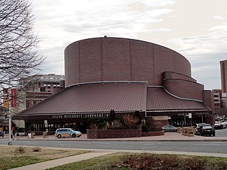
The Joseph Meyerhoff Symphony Hall, often referred to simply as the Meyerhoff, is a music venue that opened September 16, 1982, at 1212 Cathedral Street in the Mount Vernon neighborhood of Baltimore, Maryland, United States. The main auditorium has a seating capacity of 2,443 and is home to the Baltimore Symphony Orchestra. It is named for Joseph Meyerhoff, a Ukrainian-Jewish Baltimore businessman, philanthropist, and arts patron who served as president of the Baltimore Symphony from 1965 to 1983.

Washington Hill is a neighborhood in Baltimore, Maryland, United States. It is north of Fells Point, south of Johns Hopkins Hospital, east of Old Town and Jonestown and west of Butchers Hill. It is bounded by Fayette Street, Washington Street, Lombard Street, and Central Avenue. The neighborhood surrounds Broadway running north from Fells Point to terminate at East North Avenue and is named for the now-defunct Washington Medical College later known as the Church Home and Hospital on Broadway where famed writer/poet Edgar Allan Poe was taken to die in 1849 after being found comatose in a downtown Baltimore street. In the median strip of Broadway is a statue of seven-term mayor of Baltimore, Ferdinand Claiborne Latrobe.
Beth Tfiloh Dahan Community School is a private community Jewish day school in Baltimore County, Maryland. It encompasses preschool through twelfth grade. The school has one campus in Pikesville. The campus includes the PreSchool, Lower School, Middle School, and the High School. Beth Tfiloh operated a second campus in Glyndon which was sold to Shepherd Pratt in 2007. A new 56,000-square-foot (5,200 m2) Lower School complex was constructed on the Old Court campus and was completed in January 2009. Hebrew school is also offered on the Old Court campus.

Otterbein is a small neighborhood of historic rowhouses in Baltimore, Maryland, United States. Otterbein is immediately southwest of, and in close walking distance to, the Inner Harbor. The neighborhood is very compact, entirely located between Hanover Street and Sharp Street, and between Barre Street and Henrietta Street. It is in small parts of zip codes 21201 and 21230. It is named for Old Otterbein Church, located immediately north of the neighborhood.

Forest Park is a region of Northwest Baltimore, Maryland located west of Reisterstown Road, south of Northern Parkway, and east of the Baltimore City/County line. In Baltimore, the region is referred to by locals simply as "Forest Park" and includes the neighborhoods of Ashburton, Callaway-Garrison, Central Forest Park, Dolfield, Dorchester, East Arlington, Forest Park, Grove Park, Hanlon Longwood, Howard Park, Garwyn Oaks, Purnell, West Arlington, West Forest Park, and Windsor Hills.

Lombard Street is a major street in Baltimore. It forms a one-way pair of streets with Pratt Street that run west–east through downtown Baltimore. For most of their route, Pratt Street is one-way in an eastbound direction, and Lombard Street is one-way westbound. Both streets begin in west Baltimore at Frederick Avenue and end in Butcher's Hill at Patterson Park Avenue. Since 2005, these streets have been open to two-way traffic from Broadway until their end at Patterson Park; in addition, Lombard is also two-way from Fulton Avenue to Martin Luther King, Jr. Boulevard, near the University of Maryland at Baltimore campus.
The Weitzman National Museum of American Jewish History (NMAJH) is a Smithsonian-affiliated museum at 101 South Independence Mall East at Market Street in Center City Philadelphia. It was founded in 1976.
Rogers Avenue station is a Metro SubwayLink station in Baltimore, Maryland. It is located in the Woodmere area, and is the fifth most northern and western station on the line, with approximately 900 parking spaces.

University of Maryland Medical Center Midtown Campus is a hospital in the downtown area of Baltimore, Maryland. The hospital was founded for teaching purposes in 1881 by a group of local doctors. The hospital has been affiliated with the University of Maryland Medical System since 1999, and has over 1,400 employees and 500 doctors, covering 30 different specialties.

Brooklyn is one of the southernmost neighborhoods in Baltimore, Maryland. It is located near Anne Arundel County along Governor Ritchie Highway which is also Maryland Route 2. Its main roads are South Hanover Street,, Potee Street, and East Patapsco Avenue, Sixth Street, Tenth Street, and West Bay Avenue which borders the neighboring Curtis Bay community to the east, running through Bay Brook Park, which separates the two. South Hanover Street also serves as the dividing line between east–west streets in Brooklyn, as Charles Street does not exist here. Often mistaken as Brooklyn Park, Brooklyn shares the 21225 ZIP Code with the greater Brooklyn Park area which is across the Baltimore City Line in and the other neighboring community of Cherry Hill to the west and northwest across the now small western branch of the Patapsco River flowing from Ellicott City and Elkridge and along the shoreline-hugging southern extension "South Hanover Street" of the downtown's old colonial-era "Hanover Street" across the 1914-1917 Hanover Street Bridge, later renamed the Vietnam Veterans Memorial Bridge in the 1990s.

Jonestown is a neighborhood in the southeastern district of Baltimore. Its boundaries are the north side of Pratt Street, the west side of Central Avenue, the east side of Fallsway, and the south side of Orleans Street. The neighborhood lies north of the Little Italy, south of the Old Town, west of the Washington Hill, and east of the Downtown Baltimore neighborhoods. The southern terminus of the Jones Falls Expressway is located here.

Inner Harbor East, now more recently referred to more commonly as simply as Harbor East, is a relatively new mixed-use development project in Baltimore, Maryland, United States along the northern shoreline of the Northwest Branch of the Patapsco River, which is the Baltimore Harbor, and its Inner Harbor. Major tenants of Harbor East include the Baltimore Marriott Waterfront Hotel on Aliceanna Street, between the Waterfront Promenade on the west and to the east is the President Street Boulevard and the Katyn Forest Massacre Memorial (monument) in the International Drive circle at the south end.. Also, the new Legg Mason Tower, in which the famous financial services firm moved from the central downtown is located across the street. A Four Seasons Hotel opened in November 2011.
The Rotunda is a mixed-use property in northern Baltimore, Maryland in the popular neighborhood of Hampden, adjacent to the neighborhoods of Roland Park, and Wyman Park and near the campus of the Johns Hopkins University. The property features retail, office, and residential components including: 150,000 ft² of retail space, 140,000 ft² of office space, 379 apartments and over 1100 off-street parking spaces, including a multi-level parking garage featuring several electric car charging stations.
Temple Oheb Shalom is a Reform synagogue in Baltimore, Maryland. The highest point in the city is located in its parking lot.
The history of Russians in Baltimore dates back to the mid-19th century. The Russian community is a growing population and constitutes a major source of new immigrants to the city. Historically the Russian community was centered in East Baltimore, but most Russians now live in Northwest Baltimore's Arlington neighborhood and in Baltimore's suburb of Pikesville.
References
- ↑ "Jewish Working Girls Home and the Russian Night School". Baltimore Heritage. Retrieved 2021-03-01.
- ↑ "The Russian Night School on Baltimore Street". Jewish Museum of Maryland. Retrieved 2021-03-01.