
Stavanger is a city and municipality in Norway. It is the fourth largest city and third largest metropolitan area in Norway and the administrative center of Rogaland county. The municipality is the fourth most populous in Norway. Located on the Stavanger Peninsula in southwest Norway, Stavanger counts its official founding year as 1125, the year the Stavanger Cathedral was completed. Stavanger's core is to a large degree 18th- and 19th-century wooden houses that are protected and considered part of the city's cultural heritage. This has caused the town center and inner city to retain a small-town character with an unusually high ratio of detached houses, and has contributed significantly to spreading the city's population growth to outlying parts of Greater Stavanger.

Preikestolen or Prekestolen is a tourist attraction in the municipality of Strand in Rogaland county, Norway. Preikestolen is a steep cliff which rises 604 metres (1,982 ft) above Lysefjorden. Atop the cliff, there is an almost flat top of approximately 25 by 25 metres. Preikestolen is located near the Western part of the fjord, and on its North side.

Forsand is a former municipality in Rogaland county, Norway. The 780-square-kilometre (300 sq mi) municipality existed from 1871 until 2020 when it was merged into Sandnes municipality. It was located in the traditional district of Ryfylke. The administrative centre of the municipality was the village of Forsand. Other villages in the municipality included Lysebotn, Øvre Espedal, Oanes, Kolabygda, and Fløyrli.
Rennesøy is a former municipality in Rogaland county, Norway. It was merged into Stavanger municipality on 1 January 2020. It was located in the traditional district of Ryfylke. The administrative centre of the municipality is the village of Vikevåg. Other villages in Rennesøy included Askje and Sørbø. The municipality encompassed a number of islands on the south side of the Boknafjorden, north of the city of Stavanger.

Strand is a municipality in Rogaland county, Norway. It is located in the traditional district of Ryfylke. The administrative centre of the municipality is the town of Jørpeland. The municipality lies across the fjord from the city of Stavanger. The Ryfast tunnel system connects Stavanger and Strand by a very long undersea tunnel.

Lysefjord or Lysefjorden is a fjord located in the Ryfylke area in Rogaland county in southwestern Norway. The 42-kilometre (26 mi) long fjord lies in the municipalities of Strand and Sandnes, about 25 kilometres (16 mi) east of the city of Stavanger.
Boknafjord or Boknafjorden is a fjord located in Rogaland county, Norway. The huge fjord lies between the cities of Stavanger and Haugesund and dominates the central part of the county. The main part of the fjord is shared between the municipalities of Kvitsøy, Stavanger, Tysvær, Bokn, and Karmøy. There are dozens of smaller fjords that branch off the main part of the fjord, reaching most municipalities in the county. At its longest, the Boknafjord reaches about 96 kilometres (60 mi) into the mainland at the innermost point of the Hylsfjorden. Other notable branches include the Saudafjorden, Sandsfjorden, Vindafjorden, Hervikfjorden, Førresfjorden, Erfjorden, Jøsenfjorden, Årdalsfjorden, Idsefjorden, Høgsfjorden, Lysefjorden, and Gandsfjorden.
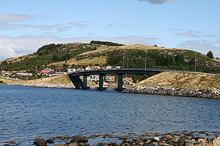
Stavanger City Bridge is a cable-stayed bridge in the city of Stavanger which is in the large Stavanger Municipality in Rogaland county, Norway. The bridge has one tower and it was one of the first larger cable-stayed bridges in Norway when it opened on 31 January 1978. The bridge crosses the Straumsteinsundet strait connecting the city centre of Stavanger to the small islands of Grasholmen and Sølyst. It is the main connection to the whole the borough of Hundvåg which is a series of islands that are all interconnected by small bridges.

The Tromsø Bridge is a cantilever road bridge in the city of Tromsø which is located in Tromsø Municipality in Troms og Finnmark county, Norway. It crosses the Tromsøysundet strait between Tromsdalen on the mainland and the island of Tromsøya. The 1,036-metre-long (3,399 ft) bridge has 58 spans, of which the longest is 80 metres (260 ft) with a maximum clearance to the sea of 38 metres (125 ft).

European route E39 is the designation of a 1,330 kilometres (830 mi) north–south road in Norway and Denmark from Klett, just south of Trondheim, to Aalborg via Bergen, Stavanger and Kristiansand. In total, there are nine ferries, more than any other single road in Europe.
The Atlantic Ocean Tunnel is an undersea tunnel that is part of Norwegian County Road 64 which connects Kristiansund Municipality to Averøy Municipality in Møre og Romsdal county, Norway. The eastern end of the tunnel is on Kirkelandet island in the town of Kristiansund and the western end of the tunnel is on the island of Averøya, just west of the village of Sveggen. The 5,727-metre (18,789 ft) long tunnel runs beneath the Bremsnesfjorden, reaching a depth of 250 metres (820 ft), making it one of the deepest undersea tunnels in the world. Construction began in 2006, and the tunnel opened on 19 December 2009, later than initially estimated. Breakthrough was in March 2009. Problems with water leaks caused delays and cost overruns.

The Eiksund tunnel is an undersea tunnel in Møre og Romsdal county, Norway, which runs under the Vartdalsfjorden connecting the municipalities of Ørsta and Ulstein. The tunnel is 7,765 metres (25,476 ft) long and reaches a depth of 287 metres (942 ft) below sea level, and was the deepest undersea tunnel in the world until Norway's Rogaland county opened its 292 m (958 ft) deep Ryfast tunnel system in December 2019.

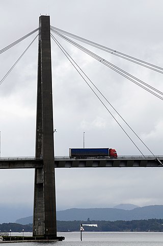
Rogaland Fixed Link or simply the Rogfast is a project, constructing a sub-sea road tunnel between the municipalities of Randaberg and Bokn in Rogaland county, Norway. The tunnel will be called the Boknafjord tunnel; it will be a world record with respect to its 27-kilometre (17 mi) length and its maximum depth of 392 metres (1,286 ft) below sea level. This will be a part of the main European route E39 highway along the west coast of Norway and it will link the cities of Kristiansand – Stavanger – Haugesund – Bergen. It is currently slated for a 2033 opening.

Storhaug is a borough of the city of Stavanger which lies in the southwestern part of the large municipality of Stavanger in Rogaland county, Norway. This borough includes the traditional city centre and main harbor along the Byfjorden. It is located east of Eiganes og Våland borough and south of the island borough of Hundvåg. The 6.43-square-kilometre (1,590-acre) borough has a population (2016) of 16,544. This gives the borough a population density of 2,573 inhabitants per square kilometre (6,660/sq mi).

The Byfjord Tunnel is a subsea road tunnel in Rogaland county, Norway. The 5,875-metre-long (19,275 ft) tunnel runs between the village of Grødem on the mainland in Randaberg municipality and the island of Sokn in Stavanger municipality, running underneath the Byfjorden. The tunnel was built as part of the Rennesøy Fixed Link project which opened in 1992 with the goal of connecting all the islands of Rennesøy to the mainland. The tunnel was a toll road from 1992 until 2006. The tunnel is part of European route E39 highway. With a maximum 8% grade, the tunnel reaches a depth of 223 metres (732 ft) below sea level at its lowest point. The tunnel was Europe's longest and the world's deepest tunnel upon its completion, it was surpassed by a deeper tunnel in 1994 and a longer tunnel in 1999. The tunnel had an average daily traffic of 9,717 vehicles in 2018.
National Road 13 is a national road which runs from the town of Stavanger in Rogaland county to the village of Sogndalsfjøra in Vestland county. The route is 449.9 kilometers (279.6 mi) long and runs south–north through Rogaland and Vestland counties, following a more inland path than the European route E39 highway.

Hundvåg is an island in Stavanger municipality in Rogaland county, Norway. The island is located in the borough of Hundvåg, just north of the centre of the city of Stavanger, separated by the Byfjorden. The 4.7-square-kilometre (1.8 sq mi) island is relatively flat and very urbanized. There were 9803 residents of the island in 2014. There are some agricultural areas as well as a lot of industry. The small island of Buøy is connected to the south side of Hundvåg by a small man-made isthmus. Hundvåg Church is located on the island.

Byfjorden is a fjord in Rogaland county, Norway. The 10-kilometre (6.2 mi) long fjord runs through the municipalities of Randaberg and Stavanger. The fjord begins at the Tungenes Lighthouse at the northern end of the Stavanger Peninsula and it flows south along the east side of the peninsula to the city of Stavanger. The islands of Bru, Åmøy, Hundvåg, Buøy, Engøy, Sølyst, and Grasholmen lie along the east side of the fjord. The fjord connects to the Boknafjorden at the north end.
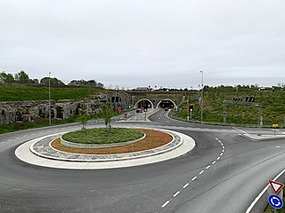
The Hundvåg Tunnel is a road tunnel in Stavanger municipality in Rogaland county, Norway. The 5.5-kilometre (3.4 mi) long tunnel is located on the Norwegian National Road 13 highway. The tunnel goes under the Byfjorden and it connects the mainland of the city of Stavanger and the island of Hundvåg. The tunnel is part of the Ryfast tunnel network that opened in 2019. The western end of the tunnel connects to the Eiganes Tunnel in the city of Stavanger. Near the eastern end of the tunnel, there is an exit to the island of Buøy as well. The tunnel exits on the island of Hundvåg, just a short distance from the entrance to the Ryfylke Tunnel, a much longer tunnel crossing the fjord to Ryfylke.

The Ryfylke Tunnel is an undersea road tunnel in Rogaland county, Norway. It is part of the Norwegian National Road 13 running between Stavanger and Ryfylke (district) under the Horgefjord. The tunnel is part of the Ryfast project. It is 14.4 kilometres (8.9 mi) long and is currently the world's longest and deepest subsea road tunnel.
