Rzgów

Last updated • 1 min readFrom Wikipedia, The Free Encyclopedia
Rzgów
Saint Stanislaus church in Rzgow (1).jpg
Church of Saint Stanislaus
POL Rzgow flag.svg
POL Rzgow COA.svg
Poland adm location map.svg
Red pog.svg
Rzgów
Coordinates: 51°39′44″N19°27′35″E / 51.66222°N 19.45972°E / 51.66222; 19.45972
Country Flag of Poland.svg  Poland
Voivodeship Łódź
County Łódź East
Gmina Rzgów
Government
  MayorMateusz Kamiński
Population
 (31 December 2020)
  Total
3,382 Increase2.svg [1]
Time zone UTC+1 (CET)
  Summer (DST) UTC+2 (CEST)
Postal code
95-030
Vehicle registration ELW
Website http://www.rzgow.pl/

Rzgów [ʐɡuf] is a town in Łódź East County, Łódź Voivodeship, in central Poland, with 3,382 inhabitants (2020). [1] It is situated on the Ner River within the Sieradz Land. The town is a member of Cittaslow.

Contents

History

It was incorporated as a town in 1467. It was a private church town, administratively located in the Piotrków County in the Sieradz Voivodeship in the Greater Poland Province of the Kingdom of Poland. [2] In 1870 it was downgraded to a village. In 1469, the Kraków Cathedral Chapter built the Saint Stanislaus church. [3]

In the interwar period, it was administratively located in the Łódź Voivodeship of Poland. According to the 1921 census, the population was 96.0% Polish and 4.0% Jewish. [4]

Following the joint German-Soviet invasion of Poland, which started World War II in September 1939, Rzgów was occupied by Germany until 1945. In July 1940, the occupiers carried out expulsions of Poles, who were deported to a transit camp in Łódź and then to the Lublin District in the more-eastern part of German-occupied Poland, while their houses were handed over to German colonists as part of the Lebensraum policy. [5]

On January 1, 2006 it became a town again.

Demographics

Historical population
YearPop.±%
1827997    
18621,559+56.4%
18902,171+39.3%
19102,091−3.7%
YearPop.±%
19211,808−13.5%
20103,359+85.8%
20203,382+0.7%
Source: [3] [4] [6] [7] [1]

Climate

Rzgów has a humid continental climate (Cfb in the Köppen climate classification).

Climate data for Rzgów
MonthJanFebMarAprMayJunJulAugSepOctNovDecYear
Mean daily maximum °C (°F)0.3
(32.5)
2.1
(35.8)
6.9
(44.4)
13.6
(56.5)
18.5
(65.3)
21.7
(71.1)
23.7
(74.7)
23.5
(74.3)
18.6
(65.5)
12.7
(54.9)
7.2
(45.0)
2.4
(36.3)
12.6
(54.7)
Daily mean °C (°F)−2.0
(28.4)
−0.8
(30.6)
3.0
(37.4)
8.9
(48.0)
14.0
(57.2)
17.5
(63.5)
19.5
(67.1)
19.1
(66.4)
14.5
(58.1)
9.3
(48.7)
4.7
(40.5)
0.4
(32.7)
9.0
(48.2)
Mean daily minimum °C (°F)−4.5
(23.9)
−3.9
(25.0)
−1.0
(30.2)
3.8
(38.8)
8.9
(48.0)
12.5
(54.5)
14.8
(58.6)
14.5
(58.1)
10.4
(50.7)
6.1
(43.0)
2.3
(36.1)
−1.7
(28.9)
5.2
(41.3)
Average precipitation mm (inches)48
(1.9)
44
(1.7)
52
(2.0)
51
(2.0)
74
(2.9)
72
(2.8)
96
(3.8)
66
(2.6)
62
(2.4)
48
(1.9)
48
(1.9)
51
(2.0)
712
(27.9)
Source: https://en.climate-data.org/europe/poland/łodz-voivodeship/rzgow-10376/

Related Research Articles

<span class="mw-page-title-main">Buk, Greater Poland Voivodeship</span> Place in Greater Poland Voivodeship, Poland

Buk is a town in Poznań County, in the Greater Poland Voivodeship, in central Poland. As of December 2021, the town has a population of 5,903.

<span class="mw-page-title-main">Kowal (town)</span> Place in Kuyavian-Pomeranian Voivodeship, Poland

Kowal is a town in Włocławek County, Kuyavian-Pomeranian Voivodeship, Poland, with 3,478 inhabitants (2004).

<span class="mw-page-title-main">Krobia</span> Place in Greater Poland Voivodeship, Poland

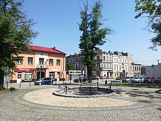
Krobia is a town situated in the western part of Poland, in Greater Poland Voivodeship. Center of small folklore region of Biskupizna.

<span class="mw-page-title-main">Brzeziny, Brzeziny County</span> Place in Łódź Voivodeship, Poland

Brzeziny is a town in Poland, in Łódź Voivodeship, about 20 kilometres (12 mi) east of Łódź. It is the capital of Brzeziny County and has a population of 12,326 as of December 2021. It is situated on the Mrożyca River within the historic Łęczyca Land.

<span class="mw-page-title-main">Tuszyn</span> Place in Łódź Voivodeship, Poland

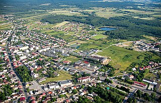
Tuszyn is a small town in Łódź East County, Łódź Voivodeship, central Poland, with 7,237 inhabitants (2020). It is located in the Sieradz Land.

<span class="mw-page-title-main">Pajęczno</span> Place in Łódź Voivodeship, Poland

Pajęczno is a town in Poland, in Łódź Voivodeship, about 40 kilometres north of Częstochowa. It is the capital of Pajęczno County. Its population is 6,651 (2020). It is located in the Sieradz Land.

<span class="mw-page-title-main">Poddębice</span> Place in Łódź Voivodeship, Poland

Poddębice is a town in central Poland, in Łódź Voivodeship, about 40 km northwest of Łódź. It is the capital of Poddębice County. Population is 7,245 (2020). It is located within the historic Łęczyca Land.

<span class="mw-page-title-main">Warta, Poland</span> Place in Łódź Voivodeship, Poland

Warta is a town in Sieradz County, Łódź Voivodeship, in central Poland, with 3,208 inhabitants (2020). It is situated on the Warta River. It is located in the Sieradz Land.

<span class="mw-page-title-main">Kamieńsk</span> Place in Łódź Voivodeship, Poland

Kamieńsk is a town in Poland, in the Łódź Voivodeship, in Radomsko County. As of 2020, it had 2,703 inhabitants. It is located in the Sieradz Land.

<span class="mw-page-title-main">Borek Wielkopolski</span> Place in Greater Poland Voivodeship, Poland

Borek Wielkopolski is a town in Poland, in the Gostyń County in the Greater Poland Voivodeship, with 2,485 inhabitants as of June 2021.

<span class="mw-page-title-main">Jutrosin</span> Place in Greater Poland Voivodeship, Poland

Jutrosin is a town in Rawicz County, Greater Poland Voivodeship, Poland, with 1,947 inhabitants (2014). The rivers Orla and Radęca converge near the town.

<span class="mw-page-title-main">Wielichowo</span> Place in Greater Poland Voivodeship, Poland

Wielichowo is a town in Grodzisk Wielkopolski County, Greater Poland Voivodeship, in western Poland, with 1,746 inhabitants (2010).

<span class="mw-page-title-main">Raszków</span> Place in Greater Poland Voivodeship, Poland

Raszków is a town in Ostrów Wielkopolski County, Greater Poland Voivodeship, Poland, with 2,080 inhabitants (2010).

<span class="mw-page-title-main">Czempiń</span> Place in Greater Poland Voivodeship, Poland

Czempiń is a town in Kościan County, Greater Poland Voivodeship, Poland. As of December 2021, the town has a population of 4,921.

<span class="mw-page-title-main">Ślesin</span> Place in Greater Poland Voivodeship, Poland

Ślesin is a town in Konin County, Greater Poland Voivodeship, in central Poland, with 3,200 inhabitants (2010).

<span class="mw-page-title-main">Lwówek</span> Place in Greater Poland Voivodeship, Poland

Lwówek is a town in Nowy Tomyśl County, Greater Poland Voivodeship, Poland, with 2,961 inhabitants (2010).

<span class="mw-page-title-main">Grabów nad Prosną</span> Place in Greater Poland Voivodeship, Poland

Grabów nad Prosną is a town in Ostrzeszów County, Greater Poland Voivodeship, Poland, with about 1,900 inhabitants.

<span class="mw-page-title-main">Działoszyn</span> Place in Łódź Voivodeship, Poland

Działoszyn is a town in Pajęczno County, Łódź Voivodeship, in south-central Poland, with 5,627 inhabitants as of December 2021.

<span class="mw-page-title-main">Bolesławiec, Łódź Voivodeship</span> Town in Łódź Voivodeship, Poland

Bolesławiec is a town in Wieruszów County, Łódź Voivodeship, in south-central Poland. It is the seat of the gmina called Gmina Bolesławiec. It lies approximately 12 kilometres (7 mi) south of Wieruszów and 110 km (68 mi) south-west of the regional capital Łódź.

Wylazłów is a village in the administrative district of Gmina Poddębice, within Poddębice County, Łódź Voivodeship, in central Poland.

References

  1. 1 2 3 "Local Data Bank". Statistics Poland. Retrieved 13 November 2021. Data for territorial unit 1006104.
  2. Atlas historyczny Polski. Województwo sieradzkie i województwo łęczyckie w drugiej połowie XVI wieku. Część I. Mapy, plany (in Polish). Warszawa: Instytut Historii Polskiej Akademii Nauk. 1998. p. 4.
  3. 1 2 Słownik geograficzny Królestwa Polskiego i innych krajów słowiańskich, Tom X (in Polish). Warszawa. 1889. pp. 166–167.{{cite book}}: CS1 maint: location missing publisher (link)
  4. 1 2 Skorowidz miejscowości Rzeczypospolitej Polskiej (in Polish). Vol. II. Warszawa: Główny Urząd Statystyczny. 1925. p. 63.
  5. Wardzyńska, Maria (2017). Wysiedlenia ludności polskiej z okupowanych ziem polskich włączonych do III Rzeszy w latach 1939-1945 (in Polish). Warszawa: IPN. pp. 256–257. ISBN   978-83-8098-174-4.
  6. Dokumentacja Geograficzna (in Polish). Vol. 3/4. Warszawa: Instytut Geografii Polskiej Akademii Nauk. 1967. p. 44.
  7. Stan i struktura ludności oraz ruch naturalny w przekroju terytorialnym w 2010 r. (PDF) (in Polish). Warszawa: Główny Urząd Statystyczny. 2011. p. 63. Archived from the original (PDF) on 13 November 2011.