The Berlin S-Bahn is a rapid transit railway system in and around Berlin, the capital city of Germany. It has been in operation under this name since December 1930, having been previously called the special tariff area Berliner Stadt-, Ring- und Vorortbahnen. It complements the Berlin U-Bahn and is the link to many outer-Berlin areas, such as Berlin Brandenburg Airport. As such, the Berlin S-Bahn blends elements of a commuter rail service and a rapid transit system.

S2 is a line on the Berlin S-Bahn. It operates from Bernau to Blankenfelde over:

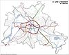
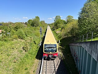
The S26 is a service of the Berlin S-Bahn. It runs from Teltow in the district (Kreis) of Potsdam-Mittelmark via Südkreuz, through the Berlin Nord-Süd Tunnel with a stop at Friedrichstraße, and ends in Blankenburg in the borough of Pankow. On weekends the S26 runs from Teltow to Potsdamer Platz. The current service began operation in December 2017.

The Potsdamer Bahnhof is a former railway terminus in Berlin, Germany. It was the first railway station in Berlin, opening in 1838. It was located at Potsdamer Platz, about 1 km south of the Brandenburg Gate, and kick-started the transformation of Potsdamer Platz from an area of quiet villas near the south-east corner of the Tiergarten park into the bustling focal point that it eventually became. For more than a century it was the terminus for long-distance and suburban trains. Also located at this spot were underground stations on the Berlin U-Bahn and S-Bahn, and today's new underground Regionalbahnhof, known as Bahnhof Potsdamer Platz, while the short-lived M-Bahn crossed the site of the former terminus.

Teltow [German pronunciation:['tɛltoː] ] is a town in the Potsdam-Mittelmark district, in Brandenburg, Germany.
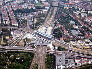
Berlin Südkreuz station is a railway station in the German capital Berlin. The station was originally opened in 1898 and is an interchange station. The Berlin Ringbahn line of the Berlin S-Bahn metro railway is situated on the upper level and connects to the east and west, whilst the Anhalter Bahn and Dresdner Bahn intercity railway routes reach the station on the lower, north-south level. The station was extensively rebuilt between the late 1990s and 2006, and was renamed Berlin Südkreuz on 28 May 2006.

Berlin Potsdamer Platz is a railway station in Berlin. It is completely underground and situated under Potsdamer Platz in central Berlin. Regional and S-Bahn services call at the station, and it is also served by U-Bahn line U2.

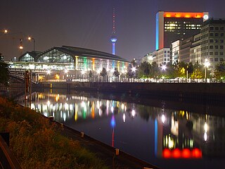
Berlin Gesundbrunnen station is a railway station in Berlin, Germany. It is situated in the Gesundbrunnen district, part of the central Mitte borough, as an interconnection point between the northern Ringbahn and Nord-Süd Tunnel lines of the Berlin S-Bahn, as well as a regional and long distance station of the Deutsche Bahn network. The station is operated by the DB Station&Service subsidiary of Deutsche Bahn AG and is classified as a Category 1 station, one of 21 in Germany and four in Berlin, the others being Berlin Hauptbahnhof, Berlin Südkreuz and Berlin Ostbahnhof.

The Berlin–Halle railway, sometimes called the Anhalt railway, is a twin-track, electrified main line found in the German city and state of Berlin, and the states of Brandenburg and Sachsen-Anhalt. The railway was originally built and managed by the Berlin-Anhaltische Eisenbahn-Gesellschaft.

Lankwitz station is on the Anhalt Suburban Line in the suburb of Lankwitz in the Berlin borough of Steglitz-Zehlendorf. It is served by S-Bahn line S25 and S-Bahn line S26. It has a south-western entrance on Brucknerstraße. Its north-eastern entrance connects to a path which runs to the south-east through a pedestrian tunnel running under the S-Bahn and the mainline to the square in front of Lankwitz Rathaus. In the other direction, this path provides a barrier-free access to Kaulbachstraße.

Berlin-Lichterfelde Ost station is on the Anhalt Suburban Line in Lichterfelde in the Berlin borough of Steglitz-Zehlendorf. It is served by S-Bahn line S25, S-Bahn line S26, and Regional-Express lines 3, 4 and 5.
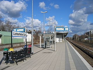
Berlin-Lichterfelde Süd station is a Berlin S-Bahn station on the Anhalt Suburban Line in Lichterfelde in the Berlin borough of Steglitz-Zehlendorf. The station was the southern terminus for S-Bahn trains on the Anhalt Suburban Line between 1943 and 1951, between 1961 and 1984 and between 1998 and 2005. From 1951 until the building of the Berlin Wall, services continued past the city limits to nearby Teltow. The station was closed between 1984 and 1998. Since 2005, the trains have run to Teltow Stadt.

Teltow Stadt (town) station is located about 500 metres (1,600 ft) east of the centre of Teltow in the German state Brandenburg to the south of Berlin on the Berlin-Lichterfelde Süd–Teltow Stadt railway. The line and the station were opened on 24 February 2005. It has two tracks next to an island platform and is located in a cutting. Mahlower Straße crosses over it on a bridge. Stairs and a lift connect the station to the street. Although the town of Teltow is in the Potsdam-Mittelmark district, the station is in the adjoining Teltow-Fläming district. The station should not be confused with Teltow railway station, which is 2 kilometres (1.2 mi) to the south-east on the Anhalt Railway itself, and is served by Regional-Express lines 3, 4 and 5.

The North–South S-Bahn Tunnel is the central section of the North–South transversal Berlin S-Bahn connection crossing the city centre. It is not to be confused with the Tunnel Nord-Süd-Fernbahn, the central tunnel part of the North–South main line used by intercity and regional trains. The S-Bahn North–South line encompasses the route from Bornholmer Straße and Gesundbrunnen via Friedrichstraße and Anhalter Bahnhof to Papestraße and Schöneberg.

The Wannsee Railway is a suburban railway in Berlin running from Potsdamer Platz via the Ring line station of Schöneberg to Wannsee station on Großer Wannsee, a lake after which it is named. Today it is a section of the Berlin S-Bahn line S1.
The Anhalt suburban line is a suburban railway in Berlin and Brandenburg. It originally ran from Potsdamer Ringbahnhof in Berlin over the Berlin–Halle railway. With the opening of the Berlin Nord-Süd Tunnel in 1939, this service was abandoned. Subsequently, the electric services ran to the south parallel with the long-distance tracks of the Anhalt Railway. Its terminus was at Berlin-Lichterfelde Ost until the 1940s. In 1943, it was extended to Lichterfelde Süd for electric trains and to Ludwigsfelde for steam trains. The construction of the Berlin Wall in 1961 stopped services at the outskirts of Berlin. In 2005, a new Berlin-Lichterfelde Süd–Teltow Stadt S-Bahn line was opened.

Teltow station is located in the town of Teltow on the Anhalt Railway south of Berlin and was opened in 1901. Since then, the station has been repeatedly remodelled. The station served regional passenger and freight traffic and was the terminus of a Berlin S-Bahn service from 1950 to 1961. The direct connection to Berlin was lost with the construction of the Berlin Wall in 1961. It was restored in 2006.

Ludwigsfelde station is located in the town of Ludwigsfelde on the Anhalt Railway south of Berlin and is one of the oldest railway stations in the German state Brandenburg. The station building, which was built around 1880, is a listed building and is the second oldest building in the town. It now houses a museum. Several houses in the railway station area are also listed buildings.
The Berlin-Lichterfelde Süd–Teltow Stadt railway is a single-track railway in the German states of Berlin and Brandenburg. It is electrified by bottom contact third rail at 750 V DC and is used by the trains on line S25 of the Berlin S-Bahn. The line begins in Lichterfelde Süd station and branches on the outskirts of Berlin from the Anhalt Suburban Line. The line was opened to Teltow Stadt in 2005. There were already plans for this line and an extension to Stahnsdorf in the period between the two world wars.

The Berlin S-Bahn began on 8 August 1924 with the first section from Stettiner Vorortbahnhof to Bernau using steam locomotives. On 13 August 1961 it was broken up when the Berlin Wall was built, resulting in two sections: the eastern part and the western part. The western part experienced a massive strike which resulted in closure of several stations, after declining use. Attempts were made to reopen at various times but in the end, only three lines were finally opened after the strike. Since 9 November 1989, when the Berlin Wall was opened, the Berlin S-Bahn began to expand rapidly with their budgetary costs.