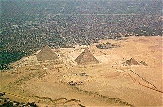
The Great Pyramid of Giza is the oldest and largest of the three pyramids in the Giza pyramid complex bordering what is now El Giza, Egypt. It is the oldest of the Seven Wonders of the Ancient World, and the only one to remain largely intact.
Djoser was an ancient Egyptian pharaoh of the 3rd dynasty during the Old Kingdom and the founder of this epoch. He is also known by his Hellenized names Tosorthros and Sesorthos. He was the son of king Khasekhemwy and queen Nimaathap, but whether he also was the direct throne successor is still unclear. Most Ramesside Kinglists name a king Nebka before him, but since there are still difficulties in connecting that name with contemporary Horus names, some Egyptologists question the received throne sequence.
Teti, less commonly known as Othoes, sometimes also Tata, Atat, or Athath in outdated sources, was the first pharaoh of the Sixth dynasty of Egypt. He is buried at Saqqara. The exact length of his reign has been destroyed on the Turin King List but is believed to have been about 12 years.

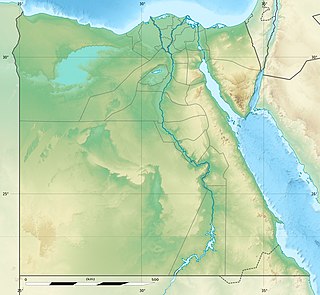
The Egyptian pyramids are ancient pyramid-shaped masonry structures located in Egypt. As of November 2008, sources cite either 118 or 138 as the number of identified Egyptian pyramids. Most were built as tombs for the country's pharaohs and their consorts during the Old and Middle Kingdom periods.

Menkauhor Kaiu was an Ancient Egyptian pharaoh of the Old Kingdom period. He was the seventh ruler of the Fifth Dynasty at the end of the 25th century BC or early in the 24th century BC.
Abusir is the name given to an Egyptian archaeological locality – specifically, an extensive necropolis of the Old Kingdom period, together with later additions – in the vicinity of the modern capital Cairo. The name is also that of a neighbouring village in the Nile Valley, whence the site takes its name. Abusir is located several kilometres north of Saqqara and, like it, served as one of the main elite cemeteries for the ancient Egyptian capital city of Memphis. Several other villages in northern and southern Egypt are named Abusir or Busiri.
Abusir is one relatively small segment of the extensive "pyramid field" that extends from north of Giza to below Saqqara. The locality of Abusir took its turn as the focus of the prestigious western burial rites operating out of the then-capital of Memphis during the Old Kingdom 5th Dynasty. As an elite cemetery, neighbouring Giza had by then "filled up" with the massive pyramids and other monuments of the 4th Dynasty, leading the 5th Dynasty pharaohs to seek sites elsewhere for their own funerary monuments.

Gisr el-Mudir also known as the Great Enclosure, is the oldest known stone structure in Egypt, located at Saqqara only a few hundred metres west of the Step Pyramid and the Buried Pyramid. The function of the space is not yet clear.

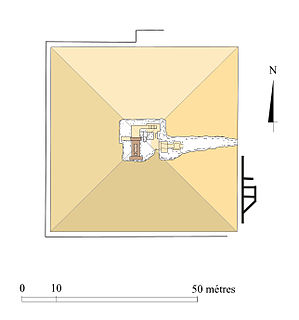
The Pyramid of Unas is a smooth-sided pyramid built in the 24th century BC for the Egyptian pharaoh Unas, the ninth and final king of the Fifth Dynasty. It is the smallest Old Kingdom pyramid, but significant due to the discovery of Pyramid Texts, spells for the king's afterlife incised into the walls of its subterranean chambers. Inscribed for the first time in Unas's pyramid, the tradition of funerary texts carried on in the pyramids of subsequent rulers, through to the end of the Old Kingdom, and into the Middle Kingdom through the Coffin Texts which form the basis of the Book of the Dead.

The Lepsius list of pyramids is a list of sixty-seven Ancient Egyptian pyramids established in 1842–1843 by Karl Richard Lepsius (1810–1884), an Egyptologist and leader of the "Prussian expedition to Egypt" from 1842 until 1846.

The Imhotep Museum is an archaeological museum located at the foot of the Saqqara necropolis complex, near Memphis in Lower Egypt.
The Pyramid of Ameny Qemau is an ancient Egyptian pyramid located in southern Dahshur. It was constructed c. 1790 BC for Ameny Qemau, the 5th king of the 13th Dynasty during the Second Intermediate Period. The stone constituting its upper structure has been entirely robbed but the damaged substructures remain. The pyramid was discovered by Charles Arthur Musès in 1957 and excavated in 1968. The pyramid originally stood 35 metres (115 ft) high with a base length of 52 metres (171 ft). The burial chamber comprised from a single colossal block of quartzite similar to that of Amenemhat III, with receptacles for the sarcophagus and the canopic jars hewn out of the interior of the block.
The pyramid complex of Userkaf was built c. 2490 BC for the pharaoh Userkaf, founder of the 5th dynasty of Egypt. It is located in the pyramid field at Saqqara, on the north-east of the step pyramid of Djoser. Constructed in dressed stone with a core of rubble, the pyramid is now ruined and resembles a conical hill in the sands of Saqqara. For this reason, it is known locally as El-Haram el-Maharbish, the "Heap of Stone" and was recognized as a royal pyramid by western archaeologists in the 19th century.

The Mastabat al-Fir’aun is the grave monument of the ancient Egyptian king Shepseskaf, the last king of the Fourth Dynasty documented to date. It is located in South Saqqara halfway between the Step Pyramid of Djoser at Saqqara and the pyramids of Sneferu, the founder of the fourth dynasty, at Dahshur. The structure is located close to the pyramid of Pepi II, a ruler of the Sixth Dynasty. The stone quarry for the structure is located west of the Red Pyramid of Sneferu.

The Buried Pyramid is an unfinished step pyramid constructed ca. 2645 BC for Sekhemkhet Djoserty. This pharaoh was the second of the Third Dynasty of Ancient Egypt, which reigned over Egypt circa 2686–2613 BC and is usually placed at the beginning of the Old Kingdom of Egypt. Many historians believe that the third dynasty played an important role in the transition from Early Dynastic Period of Egypt to the Age of the Pyramids.
Sesheshet, occasionally known as Sesh, was the mother of King Teti, the first and founding pharaoh of the sixth dynasty of Ancient Egypt. She was instrumental in enabling her son to gain the throne and reconciling two warring factions of the royal family.

The Pyramid of Merikare is an ancient Egyptian pyramid that remains unidentified, but is attested by inscriptions on funerary steles and possibly is located in Saqqara. The pyramid is presumed to be the burial place of the Herakleopolitan pharaoh Merikare, who ruled toward the end of the Tenth Dynasty c. 2040 BC during the First Intermediate Period. Sometimes, the Headless Pyramid in North Saqqara is identified as the pyramid of Merikare, although the latter is more likely to belong to pharaoh Menkauhor.
The Pyramid of Reherishefnakht is the tomb of the ancient Egyptian official Reherishefnakht. It is located in south Saqqara and was built right next to the Pyramid of the 6th Dynasty Pharaoh Pepi I. Reherishefnakht's pyramid however was probably built at the end of the 11th Dynasty or the beginning of the 12th Dynasty. It is the oldest Egyptian pyramid built for a person who was not a member of the royal family. The pyramid was discovered a few years before it was first excavated by Audran Labrousse and the Mission Archéologique Française de Saqqâra in 2005.
The Edfu South Pyramid is part of a group of seven very similar small step pyramids which were all built far from the main centres of Egypt and about which very little is known, along with the pyramids of Elephantine, el-Kula, Naqada, Saujet el-Meitin, Sinki and Seila. It is located about five kilometres south of Edfu near Naga el-Ghoneimeya. It was first identified as a pyramid in 1979, when the German archaeologists Günter Dreyer and Werner Kaiser were leading a survey of Edfu after a tip off from the inspector. Further investigation and surveys of the surrounding area have been undertaken since 2010 by the Oriental Institute of the University of Chicago.
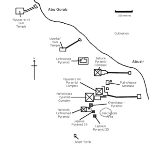
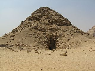
The Lepsius XXIV Pyramid is an Egyptian pyramid, which was probably built for a wife of King Nyuserre Ini. The largely destroyed 5th Dynasty structure is located in the pyramid field of Abusir, east of the Pyramid of Neferefre and south of the Pyramid of Khentkaus II.