Ibiza is a Spanish island in the Mediterranean Sea off the eastern coast of the Iberian Peninsula. It is 150 kilometres from the city of Valencia. It is the third largest of the Balearic Islands in area, but the second-largest by population. Its largest settlements are Ibiza Town, Santa Eulària des Riu, and Sant Antoni de Portmany. Its highest point, called Sa Talaiassa, is 475 metres above sea level.
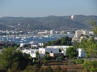
Sant Antoni de Portmany, or simply Sant Antoni, is a town on the western coast of Ibiza, the second-largest town and municipality on the island. It is situated on Sant Antoni Bay on the west coast of the island, part of the Spain autonomous community of the Balearic Islands.

Sant Josep de sa Talaia is a village and municipality of the Balearic Islands in western Ibiza. The village is 10.7 miles (17.2 km) west of the capital Eivissa and is located on the PM803 highway between Eivissa town and Sant Antoni de Portmany. The town is 6.5 miles (10.5 km) from the island's airport. As of 2006, the population of the municipality is 26,133.

Platja d'en Bossa is a major holiday resort on the Spanish island of Ibiza primarily catering for the British, German and Italian package holiday market. It is situated in the municipality of Sant Josep de sa Talaia, approximately 3 kilometres (1.9 mi) to the South of Ibiza Town. The island's main airport is approximately 3.2 kilometres (2.0 mi) away from Platja d'en Bossa.
A Natural Area of Special Interest is a protected area within the Balearic Islands, Spain that is below the level of a natural park.
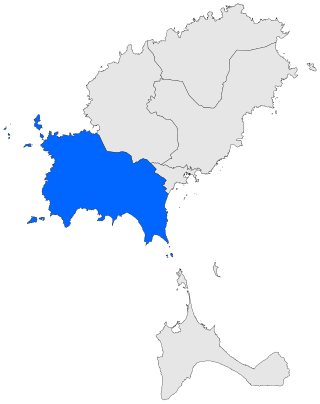
Sant Josep de sa Talaia is a municipality in the South West of Ibiza. The municipality is part of the Spanish autonomous community of the Balearic Islands. The total number of inhabitants in the municipality (2006) is 19,244.

Sant Jordi de ses Salines is a small village in the south of the Spanish island of Ibiza. The village is in the municipality of Sant Josep de sa Talaia and is located close to the islands main Airport and straddles the designated road PM-802. The village is 2.5 miles (4.0 km) south west of Ibiza Town and 2.3 miles (3.7 km) of Ibiza Airport.

Cala Comte is a beach in the south west of the Spanish island of Ibiza. It is in the municipality of Sant Josep de sa Talaia and is 5.0 miles (8.0 km) west of the village of Sant Agustí des Vedrà.
Platja Es Pinet is in a small cove within the bay of Sant Antoni Bay. The beach is on the northern seaboard of the Spanish island of Ibiza. Although it is but a short distance from Sant Antoni, It is in the municipality of Sant Josep de sa Talaia. Platja Es Pinet is 11.9 miles (19.2 km) north west of Ibiza town, and 2.9 miles (4.7 km) west around the bay from Sant Antoni.In 2012 Platja Es Pinet is one of the 12 blue flag beaches on the island. The beach sand is soft and the water is safe, clean, and shallow.

Cala Tarida is a beach resort on the western seaboard of the Spanish island of Ibiza. It is in the municipality of Sant Josep de sa Talaia and is 13.3 miles (21.4 km) west of the town of Ibiza town. The nearest village of Santa Agnès de Corona is 5.2 miles (8.4 km) east of the resort.

Cala d’Hort is a beach on the western seaboard of the Spanish island of Ibiza. The beach is in the municipality of Sant Josep de sa Talaia and is 13.3 miles (21.4 km) west of the town of Ibiza town. The village of Sant Josep de sa Talaia is 7.0 miles (11.3 km) east of the beach. In 2012 Cala d’Hort is one of the 12 blue flag beaches on the island.

Sa Caleta is a cove on the south west seaboard of the Spanish island of Ibiza. The cove is in the municipality of Sant Josep de sa Talaia and is 6.8 miles (10.9 km) west of the town of Ibiza town. The village of Sant Josep de sa Talaia is 5.7 miles (9.2 km) east of the cove.61562871399953

Cala Bassa is a beach in the north western seaboard of the Spanish island of Ibiza. It is in the municipality of Sant Josep de sa Talaia and is 15.5 miles (24.9 km) north west of the town of Ibiza town. The nearest village of Santa Agnès de Corona is 4.6 miles (7.4 km) south east of the beach.

Cala Vadella is a small cove and beach resort on the western seaboard of the Spanish island of Ibiza. The beach resort is in the municipality of Sant Josep de sa Talaia and is 14.5 miles (23.3 km) west of the town of Ibiza town. The nearest village of Sant Josep de sa Talaia is 5.3 miles (8.5 km) east of the beach resort. In 2012 Cala Vadella is one of the 12 blue flag beaches on Ibiza.

Cap Blanca is a beach on the western seaboard of the Spanish island of Ibiza. The Beach has a good view of the rock island of Es Vedrà which lies a little of the coast here. The beach is in the municipality of Sant Josep de sa Talaia and is 13.3 miles (21.4 km) west of the town of Ibiza town. The village of Sant Josep de sa Talaia is 7.0 miles (11.3 km) east of the beach.
Port d'es Torrent is in a small cove within the bay of Sant Antoni Bay. The beach is on the northern seaboard of the Spanish island of Ibiza. Although it is but a short distance from Sant Antoni, it is in the municipality of Sant Josep de sa Talaia. Platja d'es Torrent is 12.6 miles (20.3 km) north west of Ibiza town, and 3.6 miles (5.8 km) west around the bay from Sant Antoni. In 2012 Port d'es Torrent is one of the 12 blue flag beaches on the island.
Illa des Bosc is a small uninhabited island of the north west seaboard of the Spanish island of Ibiza. It is within the municipality of Sant Josep de sa Talaia and is a short distance due north of the beach of Cala Comte. The island is 5.8 kilometres (3.6 mi) west of the town of Sant Antoni de Portmany and is one of the smaller islands of the Balearic archipelago.
Sant Agustí may refer to:

Penya Esportiva Sant Jordi is a Spanish football club based in Sant Josep de sa Talaia, in the island of Ibiza, in the Balearic Islands. Founded in 1949, it plays in Tercera Federación – Group 11, holding home games at Campo Municipal Kiko Serra, with a capacity of 2,000 people.

