Sackville Street (Manchester)

Last updated

Coordinates: 53°28′30″N2°14′06″W / 53.475°N 2.235°W / 53.475; -2.235

Geographic coordinate system Coordinate system

A geographic coordinate system is a coordinate system that enables every location on Earth to be specified by a set of numbers, letters or symbols. The coordinates are often chosen such that one of the numbers represents a vertical position and two or three of the numbers represent a horizontal position; alternatively, a geographic position may be expressed in a combined three-dimensional Cartesian vector. A common choice of coordinates is latitude, longitude and elevation. To specify a location on a plane requires a map projection.

Sackville Street towards city centre Manchester Sackville Street towards city centre.jpg
Sackville Street towards city centre

Sackville Street is a street in Manchester city centre, England.

Street A public thoroughfare in a built environment

A street is a public thoroughfare in a built environment. It is a public parcel of land adjoining buildings in an urban context, on which people may freely assemble, interact, and move about. A street can be as simple as a level patch of dirt, but is more often paved with a hard, durable surface such as concrete, cobblestone or brick. Portions may also be smoothed with asphalt, embedded with rails, or otherwise prepared to accommodate non-pedestrian traffic.

Manchester city centre central business district of the City of Manchester, England

Manchester city centre is the central business district of Manchester, England, within the boundaries of Trinity Way, Great Ancoats Street and Whitworth Street. The City Centre ward had a population of 17,861 at the 2011 census.

Sackville Street runs in a northwest-southeast direction and is split into two sections by Whitworth Street, which runs in a northeast-southwest direction. At the northern end of the street is a junction with Portland Street. The northern half of the street runs through Manchester's Gay Village and past Chorlton Street Coach Station. Here the street crosses Canal Street and is carried by a bridge over the Rochdale Canal and there is also a small public park, Sackville Gardens. Beyond Whitworth Street the southern half of the street runs through what was until 2004 the campus of the University of Manchester Institute of Science and Technology (UMIST), which is now part of the University of Manchester (the Sackville Street Campus). [1] Here the street crosses Granby Row and runs under a railway viaduct, which carries the line between Manchester's Piccadilly and Oxford Road railway stations. It then continues past Charles Street (right) to its southern end where there is a junction with the Mancunian Way (the A57). [2] The song 'Sackville' by Inspiral Carpets is about the street.

Whitworth Street

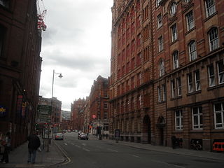
Whitworth Street is a street in Manchester, England. It runs between London Road (A6) and Oxford Street (A34). West of Oxford Street it becomes Whitworth Street West which then goes as far as Deansgate (A56). It was opened in 1899 and is lined with many large and grand warehouses. It is named after the engineer Joseph Whitworth whose works once stood along the route. Whitworth Street West runs alongside the viaduct connecting Oxford Road and Deansgate railway stations: beyond Albion Street the Rochdale Canal is on the northern side. On the Albion Street corner is the building once occupied by the Haçienda nightclub at nos. 11-13 while further east on the same side is the Ritz.

Portland Street

Portland Street is a popular street in Kowloon, Hong Kong. The street is known for its business and retailing skyscraper complex Langham Place, numerous restaurants and its red-light district.

Canal Street (Manchester) street in Manchester

Canal Street, the centre of the Manchester Gay Village, is a street in Manchester city centre in North West England. The pedestrianised street, which runs along the west side of the Rochdale Canal, is lined with gay bars and restaurants. At night time, and in daytime in the warmer months, the street is filled with visitors, often including gay and lesbian tourists from all over the world. The northern end of the street meets Minshull Street and the southern meets Princess Street; part of the street looks across the Rochdale Canal into Sackville Park.

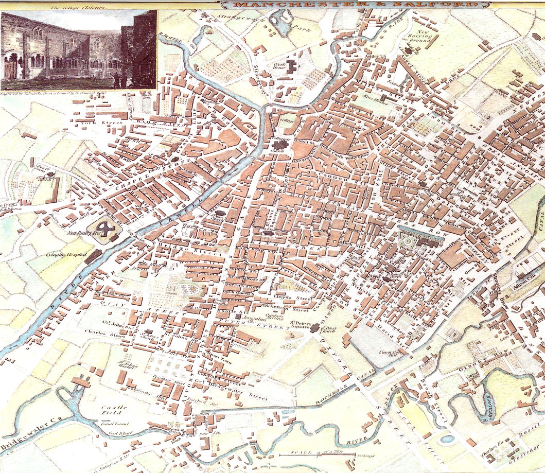
An 1801 map shows Sackville Street extending no further than the Rochdale Canal and an 1844 railway plan indicates that the part of the road extending south of the canal was called ¨Zara Street¨. [3]

Rochdale Canal

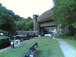
The Rochdale Canal is a navigable broad canal in Northern England, between Manchester and Sowerby Bridge, part of the connected system of the canals of Great Britain. Its name refers to the town of Rochdale, in Greater Manchester, through which it passes.

See also

Related Research Articles

Leeds and Liverpool Canal

The Leeds and Liverpool Canal is a canal in Northern England, linking the cities of Leeds and Liverpool.

A41 road major trunk road in England

The A41 is a major trunk road in England that links London and Birkenhead, although it has now in parts been superseded by motorways. It passes through or near various towns and cities including Watford, Kings Langley, Hemel Hempstead, Aylesbury, Solihull, Birmingham, West Bromwich, Wolverhampton, Newport, Whitchurch, Chester and Ellesmere Port.

Castlefield human settlement in United Kingdom

Castlefield is an inner city conservation area of Manchester in North West England. The conservation area which bears its name is bounded by the River Irwell, Quay Street, Deansgate and Chester Road. It was the site of the Roman era fort of Mamucium or Mancunium which gave its name to Manchester. It was the terminus of the Bridgewater Canal, the world's first industrial canal, built in 1764; the oldest canal warehouse opened in 1779. The world's first passenger railway terminated here in 1830, at Liverpool Road railway station and the first railway warehouse opened here in 1831.

A57 road road in England

The A57 is a major road in England. It runs east from Liverpool to Lincoln, via Warrington, Cadishead, Irlam, Patricroft, Eccles, Salford and Manchester, then through the Pennines over the Snake Pass, around the Ladybower Reservoir, through Sheffield and past Worksop. Within Manchester a short stretch becomes the A57(M) motorway.

Shropshire Union Canal canal in North West England

The Shropshire Union Canal is a navigable canal in England. The Llangollen and Montgomery canals are the modern names of branches of the Shropshire Union (SU) system and lie partially in Wales.

Wilmslow Road major road in Manchester, England

Wilmslow Road is a major road in Manchester, England, running from Parrs Wood northwards to Rusholme. There it becomes Oxford Road and the name changes again to Oxford Street when it crosses the River Medlock and reaches the city centre.

Mancunian Way road in England

The Mancunian Way is a two mile long elevated motorway in Manchester, England. It is officially made up of the A57(M) and A635(M) motorways, although the latter does not appear on road signs for practical reasons. It is also part of two other roads: the A57 to the west, which runs east–west through Greater Manchester linking the M602 and M67 motorways, and a short section of non-motorway A635 to the east. Part of this non-motorway section collapsed on 14 August 2015 due to a sinkhole.

Sackville Gardens

Sackville Gardens in Manchester, England, is bounded by Manchester College's Shena Simon Campus on one side and Whitworth Street, Sackville Street and the Rochdale Canal and Canal Street on the others. The land was purchased by Manchester Corporation in 1900 and laid out with walks, lawns and flower beds. Known as Whitworth Gardens, it was planned to complement the Municipal College of Technology's Sackville Street Building.

Castleton railway station

Castleton railway station serves Castleton in the Metropolitan Borough of Rochdale, Greater Manchester, England. It is 8¾ miles (14 km) north of Manchester Victoria on the Caldervale Line operated and managed by Northern.

A635 road road in England

The A635 is a main road that runs between Manchester and Scawsby running east–west through Stalybridge, Saddleworth Moor, Holmfirth, Barnsley and Doncaster. The section forming the eastern part of the Mancunian Way is in fact a motorway and is officially designated as the A635(M) though there is no road sign with this designation; indeed the signs at the entrance of Mancunian Way westbound show A57(M).

A5103 road road in England

The A5103 is a major road in England. It runs from Piccadilly Gardens in Manchester city centre to junction 3 of the M56 motorway and is one of Manchester's principal radial routes.

Manchester and Salford Junction Canal

The Manchester and Salford Junction Canal was a canal in the city of Manchester. It was originally built to provide a direct waterway between the Mersey and Irwell Navigation and the Rochdale Canal. The canal opened in 1839 and was abandoned in 1922.

Manchester Inner Ring Road ring road in Greater Manchester, England

Manchester and Salford Inner Relief Route is a ring road in Greater Manchester, England. It is the product of the amalgamation of several major roads around Manchester and Salford city centres to form a circular route. It was completed in 2004 with the opening of a final section to Trinity Way.

Heywood Branch Canal

The Heywood Branch Canal was a branch of the Rochdale Canal from Castleton which led to Heywood. It opened in 1834 and carried traffic until 1937. It was abandoned in 1952, along with most of the Rochdale Canal, and although the Rochdale Canal has been reopened, the junction lies under the embankments of the M62 motorway.

Rochdale Branch Canal

The Rochdale Branch Canal was a branch of the Rochdale Canal in north-west England which led close to Rochdale Town Centre. It was in use from 1794, and was bordered by the landscaped gardens of Lark Mill House on the western bank until the 1850s. A number of industries grew up around the branch, ranging from cotton mills and an iron and brass foundry in the early years, to a bakery and jam manufactory, woolen mills and sawmills later on. The branch declined with the main canal, and was little used after the 1920s, although not officially abandoned until 1952. It was filled in during the 1960s, and the site of the main basins now lies beneath the car park of a retail shopping centre.

Sackville Street Building grade II listed architectural structure in Manchester, United kingdom

The Sackville Street Building is a building on Sackville Street, Manchester, England. The University of Manchester occupies the building which, before the merger with UMIST in 2004, was UMIST's "Main Building". Construction of the building for the Manchester School of Technology began in 1895 on a site formerly occupied by Sir Joseph Whitworth's engineering works; it was opened in 1902 by the then Prime Minister, Arthur Balfour. The School of Technology became the Manchester Municipal College of Technology in 1918.

Princess Street, Manchester

Princess Street is one of the main streets in the city centre of Manchester, England. It begins at Cross Street and runs approximately eastwards across Mosley Street, Portland Street and Whitworth Street until the point where it continues as Brook Street and eventually joins the A34.

References

  1. University of Manchester (The). "Campus Plan" . Retrieved 2009-04-02.
  2. Before the building of the Mancunian Way it was continued as St Luke's Street which ended at Rusholme Road. Geographia Plan of Central Manchester; 5 in to 1 mile. [ca. 1957]
  3. Joseph Locke, FRS, George Watson Buck & William Baker, Engineers, Manchester South Junction and Altrincham Railway: Plan and section of that portion of the intended Railway forming the junction between the Manchester and Birmingham and Liverpool and Manchester Railways. 1844, Joule Library Rare Book Collection "Manchester and Birmingham Railway". University of Manchester, Mechanical and Civil Engineering.