Cheetham Hill Road

Last updated

Cheetham Hill Road
Bury Old Road (part)
Cheetham Hill Road, Cheetham Hill.jpg
Cheetham Hill Road
Former name(s)York Street, Cheetham (part)
Length5 mi (8.0 km)
LocationRed Bank, Cheetwood, Cheetham, Cheetham Hill, Collyhurst, Crumpsall, Heaton Park, Prestwich
Postal codeM4, M7, M8, M25, M45
Coordinates 53°30′44″N2°14′38″W / 53.5121°N 2.2438°W / 53.5121; -2.2438
Northern end Whitefield, Bury
Major
junctions
UK road A665.svg A665
Southern end Corporation Street

Cheetham Hill Road is a road in north Manchester, England, running from Corporation Street in Manchester city centre to Prestwich. In Crumpsall, its name changes to Bury Old Road.

Contents

Route

Cheetham Hill Road and Bury Old Road are part of the designated A665. Cheetham Hill Road starts at the junction of the A6042 Corporation Street and the A665 Miller Street. It crosses the culverted River Irk to the east of Victoria Station. At its junction with New Bridge Street, it turns north-northeast and is straight for 1 km, to the A6010 Queen's Road (east side). This stretch was called York Street until about 1900. Cheetham Hill Road leads from here to the community of Cheetham Hill, where at Bourget Street and Crescent Road (formerly Sandy Lane), Cheetham Hill Road becomes Bury Old Road. This is the boundary between Manchester and Salford, and between postcodes M8 and M7. To the north-west is Crumpsall and to the south-east is Broughton Park. It crosses the A567 Middleton Road and passes into Prestwich, in the M25 postcode area. To the east is Heaton Park, and to the west Heaton Park Metrolink station. Bury Old Road passes over the M60 motorway and under the Bury metrolink tram line at Besses o' th' Barn Metrolink station. At Whitefield Bury Old Road joins with A56 Bury New Road, the 1827 toll road that was built to replace it.

Bury New Road is a feeder to junction 17 of the M60 (formerly M62), the trans-Pennine motorway and, here, the Manchester ring road. [1]

History

Roman Manchester ran from the castrum (fort) at the Medlock crossing in Castlefield, along Deansgate to the crossing of the River Irk at the foot of Red Bank. Cheetham Hill Road starts at the River Irk crossing. The course of the Roman road has not been determined, though it is likely that there was a path that followed Red Bank up the sandstone river cliff following the gentle gradient that was preferred by draught animals. Cheetham, with its other spelling Chetham is an interesting name, the first syllable is a Celtic pre-Roman given name, while the suffix ham, meaning settlement has a Mercian or Northumbrian post-Roman name. Almost all Manchester placename are post-Roman; this implies that Cheetham was of sufficient importance in Roman times for the Celtic name to survive. . [2]

In the Middle Ages, the land was ceded to Roger de Midleton who leased it to Henry de Chetham. A descendant was Humphrey Chetham who was born at Crumpsall Hall in 1580. Crumpsall Hall, which stood at the junction of Cheetham Hill Road, Sandy Lane (Crescent Road) and Humphrey Street, was demolished in 1825. [3] A new Crumpsall Hall was built in Crumpsall Park 300m away.

Another important estate was Stocks, at the corner of Elizabeth Street and Cheetham Hill Road. At Stocks, the main road into Manchester passed by North Street and Red Bank and over the bridge into Long Millgate. A new road called York Street cut through from here to New Bridge Street and the Miller Street-Corporation Street junction. [4] York Street was renamed Cheetham Hill Road around the turn of the nineteenth century due to the large number of York Streets in central Manchester. York Street and its parallel streets were a planned development with elements of a gridiron structure.

In the late 1830s, the very wealthy were living in villas in Crumpsall, leaving the a range of relatively cheap and spacious houses along York Street that were ideal for the traders with retail properties in town, and along Deansgate. The Jewish community had expanded into retailing-taking the skill of the hawker into fixed shops. Jacob Frank, an optician, opened a shop at 114 Deansgate, where 8 of his 11 sons became opticians: the three others moved away to open different shops in Leeds and Hull. Benjamin Hyam, who opened his Pantechnethica at 26 Market Street in April 1841 moved to Higher Broughton. [5] Successful retailers moved from garrets above their shops in town to the new inner suburbs. Joseph Braham moved onto York Street in 1841 and bought other houses which he tenanted with his co-religionists. By 1845 there were 12 Jewish retailers living along York Street or close by. [6] In 1858, two synagogues opened on York Street, the Great Synagogue and the Reformed Synagogue.

A classic hawker to shop trader story is that of Joseph and Adelina Davis who left Chodziez in Poland in 1857 and came with their children Nathan, Aaron, Elkan, David and Theresa to Manchester where they started out hawking jewellery around the north. Later, they established Davis jewellers shop in Deansgate. Two of Elkan's sons, Louis Henry Davis and Michael Joseph Davis, ran an antiques business on Long Millgate and lived at 453 Cheetham Hill Road. In July 1933, their Manchester-born sister Frances (Fanny) Levin was brutally attacked with an iron bar taken from the kitchen grate. She died of her injuries at the Jewish Memorial Hospital. A homeless former sailor, Billy Burtoft, was convicted of her murder and was executed at Strangeways prison, but, according to research carried out by local author Denise Beddows, [7] Burtoft was almost certainly innocent of the crime. 453 Cheetham Hill Road was demolished in 1958 and, the Cheetham Hebrew Congregation Synagogue was built on the site but this later[ vague ] became the Al-Hirah centre, housing a travel agent, immigration law centre and beauty parlour.

Buildings

Cheetham Town Hall Former town hall, Cheetham Hill Road, Manchester (geograph 7567247).jpg
Cheetham Town Hall

Offices

Civic buildings

Places of worship

Churches

  • Church of St John the Evangelist, Cheetham, Waterloo Road (1869–71); architects Paley & Austin [11]
  • St Chad's, York Street, Cheetham Hill Road (1846–47) architects Weightman & Hadfield; the earliest post-Reformation Roman Catholic church to establish itself in Manchester.[ citation needed ] [12]
  • St Luke's (1836–39) by Thomas Witlam Atkinson, Grade II listed. [9]

Synagogues

  • The Great Synagogue (Old Congregation), Cheetham Hill Road, Cheetham (SJ 842998) was designed by Thomas Bird; opened on 14 March 1858, and closed in 1974. It was demolished in 1986. It was built in the Italian manner with large Corinthian columns and pilasters. [13] [14]
  • Congregation of British Jews (Manchester Reform Synagogue), Park Place, Cheetham Hill Road was designed by Edward Salomons. The original building in Park Place was consecrated on 25 March 1858 but was lost during the 1 June 1941 blitz. [13]
  • Spanish and Portuguese Synagogue was designed by Edward Salomons. 1873-74. Standing but closed in 1983 when it became the Manchester Jewish Museum. [13] [14]
  • The New Congregation Synagogue, Cheetham Hill Road (formerly York Street), Cheetham.(SJ 842997) was opened in 1889, but now used as business premises. [13] [14]
  • Central Synagogue, Park Street, Park Street / Cheetham Hill Road, Cheetham (SJ 840992) became the Central Synagogue in 1894. Now used as business premises. The new Central Synagogue is located in Heywood Street, Cheetham (SD 842010) and was built in 1928. [13]
  • United Synagogue, Cheetham Hill Road, Cheetham (SJ 842997) opened in 1904 in a converted Methodist Chapel; it was demolished in 1987. [13]
  • Higher Crumpsall and Higher Broughton Hebrew Congregation. Magnificent stone-white building still in use

Mosques

  • Al-Sunnah Mosque: 13 Winterford Road, Cheetham Hill, Manchester, M8 9PD.

Public transport

The 135 Manchester-Bury bus runs the entire length of the road. The lower end, from Corporation Street to Thomas Street, is also served by the 42. On other parts of the road, the 51A, 149, 154 and 167 services run. [15]

See also

Related Research Articles

<span class="mw-page-title-main">Castlefield</span> Human settlement in England

Castlefield is an inner-city conservation area in Manchester, North West England. The conservation area which bears its name is bounded by the River Irwell, Quay Street, Deansgate and Chester Road. It was the site of the Roman era fort of Mamucium or Mancunium which gave its name to Manchester. It was the terminus of the Bridgewater Canal, the world's first industrial canal, built in 1764; the oldest canal warehouse opened in 1779. The world's first passenger railway terminated here in 1830, at Liverpool Road railway station and the first railway warehouse opened here in 1831.

<span class="mw-page-title-main">Crumpsall</span> Electoral ward in England

Crumpsall is an outer suburb and electoral ward of Manchester, England, 3 miles (5 km) north of Manchester city centre, bordered by Cheetham Hill, Blackley, Harpurhey, Broughton, and Prestwich. The population at the 2011 census was 15,959. Historically part of Lancashire, Crumpsall was a township within the parish of Manchester, Salford Hundred. North Manchester General Hospital is in Crumpsall.

<span class="mw-page-title-main">Manchester city centre</span> Central business district in England

Manchester City Centre is the central business district of Manchester, England, within the confines of Great Ancoats Street, A6042 Trinity Way, and A57(M) Mancunian Way, which collectively form an inner ring road. The City Centre ward had a population of 17,861 at the 2011 census.

<span class="mw-page-title-main">River Irk</span> River in Greater Manchester, England

The River Irk is a river in the historic county of Lancashire in the North West England that flows through the northern most Lancastrian towns of the ceremonial county of Greater Manchester.

<span class="mw-page-title-main">Prestwich</span> Town in Greater Manchester

Prestwich is a town in the Metropolitan Borough of Bury, Greater Manchester, England, 3.3 miles (5.3 km) north of Manchester city centre, 3.1 miles (5 km) north of Salford and 4.7 miles (7.6 km) south of Bury.

<span class="mw-page-title-main">Cheetham, Manchester</span> Human settlement in England

Cheetham is an inner-city area and electoral ward of Manchester, England, which in 2011 had a population of 22,562. It lies on the west bank of the River Irk, 1.4 miles (2.3 km) north of Manchester city centre, close to the boundary with Salford, bounded by Broughton to the north, Harpurhey to the east, and Piccadilly and Deansgate to the south.

<span class="mw-page-title-main">Collyhurst</span> Inner city area of Manchester, England

Collyhurst is an inner city area of Manchester, England, 1.5 miles (2.4 km) northeast of the city centre on Rochdale Road (A664) and Oldham Road (A62), bounded by Smedley, Harpurhey and Monsall to the north, Miles Platting to the east, Ancoats to the south, and the River Irk to the west. Prominent buildings include two Roman Catholic churches, St Patrick's and St Malachy's.

<span class="mw-page-title-main">Deansgate</span> Road in Manchester, England

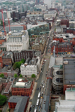
Deansgate is a main road through Manchester City Centre, England. It runs roughly north–south in a near straight route through the western part of the city centre and is the longest road in the city centre at over one mile in length.

<span class="mw-page-title-main">A56 road</span> Road in England

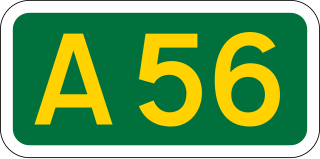
The A56 is a road in England which extends between the city of Chester in Cheshire and the village of Broughton in North Yorkshire. The road contains a mixture of single and dual carriageway sections, and traverses environments as diverse as the dense urban sprawl of inner city Manchester and the lightly populated region of rural east Lancashire. The road includes a short section of trunk road between the end of the M66 motorway near Ramsbottom and the M65 motorway west of Burnley.

<span class="mw-page-title-main">Crumpsall Park</span> Park in Manchester, England

Crumpsall Park is a small municipal park in the Crumpsall ward of Manchester, North West England.

<span class="mw-page-title-main">Woodlands Road tram stop</span> Former Manchester Metrolink tram stop

Woodlands Road was a tram stop on the Bury Line of the Metrolink system in the Cheetham Hill area of north Manchester, England. It opened in 1913 as a heavy rail station and closed for conversion to light rail in 1991, opening with the new Metrolink system in 1992.

<span class="mw-page-title-main">Architecture of Manchester</span> Overview of the architecture of Manchester, England

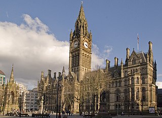
The architecture of Manchester demonstrates a rich variety of architectural styles. The city is a product of the Industrial Revolution and is known as the first modern, industrial city. Manchester is noted for its warehouses, railway viaducts, cotton mills and canals – remnants of its past when the city produced and traded goods. Manchester has minimal Georgian or medieval architecture to speak of and consequently has a vast array of 19th and early 20th-century architecture styles; examples include Palazzo, Neo-Gothic, Venetian Gothic, Edwardian baroque, Art Nouveau, Art Deco and the Neo-Classical.

<span class="mw-page-title-main">Museum of Transport, Greater Manchester</span> Transport museum in Manchester, UK

The Museum of Transport, Greater Manchester aims to preserve and promote the public transport heritage of Greater Manchester in North West England. It is located in the Cheetham Hill area of Manchester.

<span class="mw-page-title-main">Monsall tram stop</span> Manchester Metrolink tram stop

Monsall is a tram stop on the Oldham and Rochdale Line (ORL) of Greater Manchester's light-rail Metrolink system in the Monsall area of Manchester in North West England. It was built as part of Phase 3a of the system's expansion, on the route of the former Oldham Loop Line, and opened to passengers on 13 June 2012.
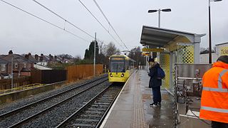
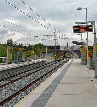
By the end of 18th century, the rapidly growing town of Manchester, England, had a small Jewish community, some of whose members had set up businesses, and a place of worship. The history of Manchester's Jewish community is told at the Manchester Jewish Museum in Cheetham. The Jewish community in Manchester is the second largest in Britain ; the first being in Greater London.

<span class="mw-page-title-main">Bury Line</span> Manchester Metrolink line

The Bury Line is a tram line of the Manchester Metrolink running from Manchester city centre to Bury in Greater Manchester. Originally a railway line, it was, along with the Altrincham Line, converted into a tram line during 1991–92, as part of the first phase of the Metrolink system.

<span class="mw-page-title-main">Oldham and Rochdale Line</span> Manchester Metrolink line

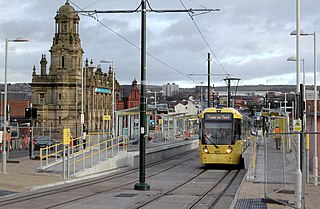
The Oldham and Rochdale Line (ORL) is a tram line of the Manchester Metrolink in Greater Manchester running from Manchester city centre to Rochdale town centre via Oldham, using most of the trackbed of the former Oldham Loop Line which closed in 2009. The line was re-opened in a modified form as a tramway between 2012 and 2014, as part of phase three of the system's expansion.

<span class="mw-page-title-main">Zone 1 (Manchester Metrolink)</span>

Zone 1 of the Manchester Metrolink light rail network is the heart of the system where all of the other lines converge. Its boundaries are broadly equivalent to those of Manchester city centre, and approximately mirror the city's Inner Ring Road. Within Zone 1, first opened in 1992 as the City Zone, trams largely run along semi-pedestrianised streets rather than on their own separate alignment. The original route between the Altrincham and Bury lines ran to Victoria station via Market Street and High Street, and was soon joined by a branch to Piccadilly station by a three-way delta junction. A second route between the South-West and North-Eastern parts of the network was built to ease congestion on the original line. Opened in 2017, the Second City Crossing (2CC) added one additional stop to the network.

<span class="mw-page-title-main">Smedley, Manchester</span>

Smedley is an area of north Manchester, England, on the banks of the River Irk between Cheetham Hill to the west, Collyhurst to the south, Crumpsall to the north and Harpurhey to the east.

References

Footnotes
  1. Street Atlas Greater Manchester (3 (2004) ed.). London E14 4JP: Philips. 1997. p. 63. ISBN   0-540-08522-7.{{cite book}}: CS1 maint: location (link)
  2. Jones 1974, p. 167.
  3. Swindells 1908, p. 13.
  4. Swindells 1908, p. 17.
  5. Williams 1976, p. 113.
  6. Williams 1976, pp. 120–126.
  7. 'The Cheetham Hill Murder - A Convenient Killing?'
  8. "DTZ Peninsula promotional website". Archived from the original on 7 January 2013. Retrieved 28 February 2013.
  9. 1 2 Parkinson-Bailey 2000, p. 321.
  10. Parkinson-Bailey 2000, p. 86.
  11. Pevsner, N. (1969) Lancashire; 1: the industrial and commercial south. (The Buildings of England.). Harmondsworth: Penguin Books; p. 338
  12. St Mary's (1794) was replaced by St Mary's in Mulberry Street in 1848
  13. 1 2 3 4 5 6 LOPC (2013). "The District of Cheetham, Manchester in the County of -- Lancashire --". Lancashire Online Parish Clerks. Retrieved 28 February 2013.
  14. 1 2 3 Parkinson-Bailey 2000, p. 85.
  15. Published Bus Maps
Bibliography