
Sacramento County is a county located in the U.S. state of California. As of the 2020 census, the population was 1,585,055. Its county seat is Sacramento, which has been the state capital of California since 1854.
Cathey Peak is a peak in the Sacramento Mountains, in the south-central part of the U.S. State of New Mexico. It lies in Otero County, 10 miles (16 km) southeast of the community of Alamogordo.

Florin station is a side platformed Sacramento RT light rail station in Sacramento, California, United States. The station was opened on September 26, 2003, and is operated by the Sacramento Regional Transit District. It served by the Blue Line. The station is located north of Florin Road at Indian Lane, and serves the surrounding residential and commercial areas along Florin Road, the Department of Human Assistance, and Luther Burbank High School.

Swanston is a side-platformed Sacramento RT light rail station between Arden Way and El Camino Avenue, just west of the Capital City Freeway, in Sacramento, California, United States. The station was opened on March 12, 1987, and is operated by the Sacramento Regional Transit District as part of the Blue Line.
Marconi/Arcade station is a side platformed Sacramento RT light rail station in Sacramento, California, United States. The station was opened on March 12, 1987, and is operated by the Sacramento Regional Transit District as part of the Blue Line. The Arcade portion in the station name comes from the surrounding neighborhood of Arden-Arcade.
University/65th Street station is a side platformed Sacramento RT light rail station in Sacramento, California, United States. The station was opened on September 5, 1987, is operated by the Sacramento Regional Transit District and is the closest station to California State University, Sacramento. It is served by the Gold Line. The station is located at the intersection of 65th Street and Q Street.
16th Street is a side platformed Sacramento RT Light Rail station in Downtown Sacramento, California, United States. The station was opened on September 5, 1987, and is operated by the Sacramento Regional Transit District. Located at 16th Street between Q and R Streets, it is served by the Gold and Blue Lines and is the easternmost station where transfers can be made between both rail lines. With a daily average of 7,100 riders, the 16th Street station is the busiest in the RT light rail system.

23rd Street is a side platformed Sacramento RT light rail station in the Midtown neighborhood of Sacramento, California, United States. The station was opened on September 5, 1987, and is operated by the Sacramento Regional Transit District. It is served by the Gold Line. The station is located at the intersection of 23rd and R Streets, and is in the Central City Fare Zone. It also serves a portion of the Richmond Grove neighborhood.
59th Street is a side platformed Sacramento RT light rail station in the Fairgrounds neighborhood of Sacramento, California, United States. The station was opened on September 5, 1987, and is operated by the Sacramento Regional Transit District. It is served by the Gold Line. The station is located near the intersection of 59th Street and Highway 50.

Power Inn is a side platformed Sacramento RT light rail station in the East Sacramento neighborhood of Sacramento, California, United States. The station was opened on September 5, 1987, and is operated by the Sacramento Regional Transit District. It is served by the Gold Line. The station is located near the intersection of Power Inn Road/Howe Avenue and Folsom Boulevard, adjacent to the U.S. 50 freeway and a major residential area, the station serves a commuter facility, via its park and ride lot.
College Greens is a side platformed Sacramento RT light rail station in the College Greens neighborhood of Sacramento, California, United States. The station was opened on September 5, 1987, and is operated by the Sacramento Regional Transit District. It is served by the Gold Line. The station is located near the intersection of Florin Perkins Road and Folsom Boulevard, in an area dominated by student housing.
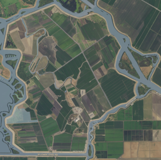
McDonald Island is an island in the Sacramento-San Joaquin River Delta, 53 km (33 mi) south of Sacramento. The 2,400 ha (5,900-acre) island is bounded on the north by San Joaquin River, on the west by Middle River and Latham Slough, and on the south by Empire Cut. It appears unlabeled on a 1913 United States Geological Survey map of the area, and on a 1952 USGS map as "McDonald Tract".

The Federal Building, formerly the U.S. Post Office, Courthouse and Federal Building, is located in Downtown Sacramento, California.

Sacramento is an unincorporated community in southeastern Hubley Township, Schuylkill County, Pennsylvania, United States, situated on Route 25. It is located on the Pine Creek, which drains it westward into the Mahantango Creek. It has a post office with the zip code of 17968.
There were two special elections in 1979 to the United States House of Representatives in the 96th United States Congress. Both of them were won by Republicans, filling seats that were vacant since the January 3, 1979 beginning of the term.

Atherton Island is a small island in the Sacramento–San Joaquin River Delta. It is in unincorporated San Joaquin County, California, part of Stockton. Its coordinates are 37°57′22″N121°21′01″W, and the United States Geological Survey measured its elevation as 13 ft (4.0 m) in 1999. It appears on a 2015 USGS map of the area.

Ida Island is a small island in the Sacramento–San Joaquin River Delta. It is part of Sacramento County, California. Its coordinates are 38°10′14″N121°38′12″W, and the United States Geological Survey measured its elevation as 3 ft (0.91 m) in 1981. It appears on a 1978 USGS map of the area.

Long Island is a small island in the Sacramento–San Joaquin River Delta. It is part of Sacramento County, California. Its coordinates are 38°10′01″N121°37′30″W, and the United States Geological Survey measured its elevation as 7 ft (2.1 m) in 1981. It appears on 1978 USGS maps of the area.
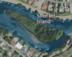
Shenkel Island is a small island in the Sacramento–San Joaquin River Delta. It is part of San Joaquin County, California. Its coordinates are 37°58′03″N121°21′40″W, and the United States Geological Survey gives its elevation as 7 ft (2.1 m).

The Rio Blanco Tract is an island in the Sacramento–San Joaquin River Delta. It is part of San Joaquin County, California, and managed by Reclamation District 2114. Its coordinates are 38°04′46″N121°24′18″W, and the United States Geological Survey measured its elevation as 0 ft (0 m) in 1981. It appears on a 1952 USGS map of the area.


