Tuscola County is a county in the Thumb region of the U.S. state of Michigan. As of the 2020 census, the population was 53,323. The county seat is Caro. The county was created by Michigan Law on April 1, 1840, from land in Sanilac County and attached to Saginaw County for administrative purposes. The Michigan Legislature passed an act on March 2, 1850, that empowered the county residents to organize governmental functions.

Saginaw County, officially the County of Saginaw, is a county located in the U.S. state of Michigan. As of the 2020 Census, the population was 190,124. The county seat is Saginaw. The county was created by September 10, 1822, and was fully organized on February 9, 1835. The etymology of the county's name is uncertain. It may be derived from Sace-nong or Sak-e-nong, as the Sauk tribe is believed by some to have once lived there. A more likely possibility is that it comes from Ojibwe words meaning "place of the outlet" –sag and ong. See List of Michigan county name etymologies.

Oakland County is a county in the U.S. state of Michigan. It is part of the metropolitan Detroit area, located northwest of the city. As of the 2020 Census, its population was 1,274,395, making it the second-most populous county in Michigan, behind neighboring Wayne County. It is the largest county in the United States without a city of 100,000 residents. The county seat is Pontiac. The county was founded in 1819 and organized in 1820.

Huron County is a county in the U.S. state of Michigan. As of the 2020 Census, the population was 31,407. The county seat is Bad Axe. Huron County is at the northern tip of the Thumb, which is a sub region of Mid Michigan. It is a peninsula, bordered by Saginaw Bay to the west and Lake Huron to the north and east, and has over 90 miles (140 km) of shoreline, from White Rock on Lake Huron to Sebewaing on the Saginaw Bay. Huron County's most important industry is agriculture, as with most of the other Thumb counties. Huron County enjoys seasonal tourism from large cities such as Detroit, Flint, and Saginaw. A lot of the tourism is in the Port Austin and Caseville area.

Gratiot County is a county in the U.S. state of Michigan. As of the 2020 Census, the population was 41,761. The county seat is Ithaca, although its most populous city is Alma.

Bay County is a county in the U.S. state of Michigan. As of the 2020 Census, the population was 103,856. The county seat is Bay City.

Frankenlust Township is a civil township of Bay County in the U.S. state of Michigan. The 2020 Census placed the population at 3,672. This is a 3.1% increase from the 3,562 recorded at the 2010 Census, the second largest increase in Bay County during that time period. The 2000 Census recorded 2,530. It is included in the Bay City Metropolitan Statistical Area. It is home to Delta College.
Delta Charter Township, officially known as the Charter Township of Delta and commonly known as simply Delta Township, is a charter township of Eaton County in the U.S. state of Michigan. As of the 2010 census, it had a population of 32,408 making it the most populous municipality in Eaton County. The township operates its own fire department, but contracts with the Eaton County Sheriff Department for police protection. The township is a major community in metropolitan Lansing.

Weidman is an unincorporated community in Isabella County, Michigan, United States. It is a census-designated place (CDP) for statistical purposes, but has no independent municipal authority. The population of the CDP was 959 at the 2010 census, up from 879 at the 2000 census.

Bridgeport is an unincorporated community in Bridgeport Charter Township, Saginaw County in the U.S. state of Michigan. It is also a census-designated place (CDP) for statistical purposes. The population was 7,849 at the 2000 census. Bridgeport is also the name of a post office with ZIP code 48722. The area served by the ZIP code includes the southeast portion of the CDP and includes southeastern portions of Bridgeport Charter Township outside of the CDP as well as portions of southwest Frankenmuth Township and a small area of northeastern Birch Run Township. The remainder of the CDP area is served by the Saginaw ZIP code 48601.

Saginaw is a city in the U.S. state of Michigan and the seat of Saginaw County. The city of Saginaw and Saginaw County are both in the area known as Mid-Michigan. Saginaw is adjacent to Saginaw Charter Township and considered part of Greater Tri-Cities region of Central Michigan. The Saginaw County MSA had a population of 190,124 in 2020. The city is also the largest municipality in the Saginaw, Midland, and Bay City Metropolitan Area, with a combined population of 377,474 in the combined statistical area in 2020. The city proper had a population of 44,202 at the 2020 census.
Industrial Township is a township in Saint Louis County, Minnesota, United States. The population was 800 at the 2010 census.
Sandy Township is a township in Saint Louis County, Minnesota, United States. The population was 356 at the 2010 census.
Pleasant Hill is an unincorporated community and census-designated place (CDP) in Lebanon County, Pennsylvania, United States. The population was 2,643 at the 2010 census, up from 2,301 at the 2000 census.
Saginaw is an unincorporated area in Saint Louis County, Minnesota, United States. Although unincorporated, Saginaw has a post office with the ZIP code 55779.
Munger is an unincorporated community in Solway Township, Saint Louis County, Minnesota, United States.
Fivepointville is an unincorporated community and census-designated place (CDP) in Brecknock Township, Lancaster County, Pennsylvania, United States. As of the 2010 census the population was 1,156. The town is named for its position at an intersection of five separate roads.

Lake Holiday is an unincorporated community and census-designated place in Union Township, Montgomery County, in the U.S. state of Indiana. It is a private community on the banks of its eponymous body of water, notable for its dam, size, and its scenic beauty.
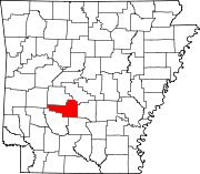
Social Hill is an unincorporated community in Hot Spring County, Arkansas, United States. Social Hill is located near Interstate 30 and Arkansas Highway 84, 6.1 miles (9.8 km) west-southwest of Malvern. The Ouachita River is one mile to the east of the community.

Lake Arkona was a stage of the lake waters in the Huron-Erie-Ontario basin following the end of the Lake Maumee levels and before the Lake Whittlesey stages, named for Arkona, Ontario, about 50 miles (80 km) east of Sarnia.