Saint-Raphaël (French pronunciation: [sɛ̃ʁafaɛl] ⓘ ; Occitan : Sant RafèuOccitan pronunciation: [ˈsanraˈfɛw] ) is a commune in the Var department, Provence-Alpes-Côte d'Azur region, Southeastern France.
Immediately to the west of Saint-Raphaël lies a larger and older town, Fréjus; together they form an urban agglomeration known as Var Estérel Méditerranée, which also encompasses the smaller communes of Les Adrets-de-l'Estérel, Puget-sur-Argens and Roquebrune-sur-Argens. In the second half of the 19th century, the township came under the influence of Mayor Felix Martin and writer Jean-Baptiste Alphonse Karr; owing to their efforts and its beneficial climate the commune developed into a seaside resort popular with artists, sportsmen and politicians.
It is the seat of the canton of Saint-Raphaël, also encompassing Fréjus and Les Adrets-de-l'Estérel, which is the economic and cultural centre of Eastern Var, within the arrondissement of Draguignan. Its inhabitants are called Raphaëlois in French generally, or Rafelencs in Provençal Occitan.
In 1799 Napoleon Bonaparte and his forces arrived by ship from Egypt, prior to his coup d'état in Paris, and landed at a fishing village that was the commune of Saint-Raphaël. [3]
The coastal double-track rail link between Saint-Raphaël and Nice passes over a substantial viaduct constructed right on the shoreline at Anthéor. These tracks were of strategic importance to the Axis forces during World War II for supplying material to units in France.
There were three separate air raids made on this viaduct from England, between September 1943 and February 1944, involving a total of thirty-one Lancaster bombers operating some seven hundred miles from base. Aircraft of the second raid flew on to Rabat, and from the third raid on to Sardinia. One Lancaster from the first raid was lost, and a flight lieutenant bomb aimer on the third raid was killed by enemy fire, some of which came from ships at sea. All the raids failed in their objective and the rail link was not severed. [4]
During World War II, on August 15, 1944, it was one of the sites of a beach landing in Operation Dragoon, the Allied invasion of southern France.
|
| ||||||||||||||||||||||||||||||||||||||||||||||||||||||||||||||||||||||||||||||||||||||||||||||||||||||||||||||||||
| |||||||||||||||||||||||||||||||||||||||||||||||||||||||||||||||||||||||||||||||||||||||||||||||||||||||||||||||||||
Source: EHESS [5] and INSEE (1968-2017) [6] |
Saint-Raphaël is located at the extreme eastern end of the Var, along the border with the adjacent département of Alpes-Maritimes, which occupies the far south-eastern corner of France at the frontier with Italy. The commune has a total of thirty-six kilometres (22 miles) of Mediterranean coastline, [7] owing mainly to the many coves and creeks formed between the natural region of the Esterel Massif (Massif de l'Esterel) and the sea. This places it second only to Marseilles, with fifty-seven kilometres (35 miles) of coastline. The commune is 89.59 km2 in extent. It is almost completely urbanised in the west, but includes over 60 km2 of protected areas of natural forest and the Esterel mountains.
Saint-Raphaël has four large sandy beaches: one near the city centre, called the Veillat; one at Boulouris; one at Le Dramont, and the fourth at Agay. There are two smaller ones at Anthéor and Le Trayas.
Saint-Raphaël is separated from Fréjus by the River Pédégal: fed by the Garonne, the Adrets-of-l'Esterel, Saint-Jean-de-Cannes and Saint-Jean-de-l'Esterel.
The River Agay flows from the mountains down through the village of that name, and is fed by the streams Cabre, Perthus and Grenouillet. The Grenouillet is the most important of these streams, having average flows of between 43 cu m/s in July and 1160 cu m/s in January.
The River Valescure, which is channelled through the Barrage des Crous (dam), discharges into the River Reyran at Fréjus.
From east to west the commune has several mountain summits rising from the massif. Mont Vinaigre in Fréjus stands at 618 metres (2,028 feet), Rastel d'Agay at 287 m (942 ft), Pic de l'Ours (carrying a transmitter aerial) at 492 m (1,614 ft), Pic du Cap Roux at 453 m (1,486 ft), and Pic d'Aurèle at 322 m (1,056 ft).
Situated almost entirely on the Esterel Massif, the commune sits on soil of red porphyr, which makes for very picturesque scenes along the coast where the soil and rocks are exposed on cliff faces and rocky shores. Three important and spectacular rocks dominate the seascape: Cap Roux at 360 m (1,180 ft), Saint-Pilon at 295 m (968 ft), and the Rock of Saint-Barthélemy.
Immediately to the west and north-west of Saint-Raphaël lies the ancient town of Fréjus. To the north lie the hamlets of Saint-Jean-de-l'Esterel et Saint-Jean-de-Cannes, both within the Fréjus commune. To the extreme north-east, beyond Le Trayas, is the small resort of Miramar, lying within the commune of Théoule-sur-Mer. The Mediterranean Sea lies to the south of the whole Saint-Raphaël commune.
St. Raphaël is located on the Côte d'Azur and enjoys a Mediterranean climate with hot, dry summers and mild, humid winters. The Mistral wind occurs, although sometimes the town is sheltered from this by the Massif des Maures and the Esterel. It is perhaps more exposed to the Levant (strong, easterly, wet) or the Sirocco (very strong, southerly, hot) air flows, but these occur rarely. The wind velocity record was established on 30 January 1986, with gusts of 140 km (87 mi) per hour.
Climate data for Saint-Raphaël [8] (1991–2020 averages, extremes 1966–2007) | |||||||||||||
---|---|---|---|---|---|---|---|---|---|---|---|---|---|
Month | Jan | Feb | Mar | Apr | May | Jun | Jul | Aug | Sep | Oct | Nov | Dec | Year |
Record high °C (°F) | 20.2 (68.4) | 21.6 (70.9) | 34.6 (94.3) | 26.7 (80.1) | 31.0 (87.8) | 34.0 (93.2) | 37.2 (99.0) | 36.5 (97.7) | 32.8 (91.0) | 28.0 (82.4) | 23.0 (73.4) | 20.5 (68.9) | 37.2 (99.0) |
Mean daily maximum °C (°F) | 12.5 (54.5) | 13.4 (56.1) | 15.9 (60.6) | 17.8 (64.0) | 22.5 (72.5) | 26.6 (79.9) | 29.7 (85.5) | 30.1 (86.2) | 25.3 (77.5) | 20.6 (69.1) | 15.9 (60.6) | 13.0 (55.4) | 20.3 (68.5) |
Daily mean °C (°F) | 9.3 (48.7) | 9.6 (49.3) | 11.9 (53.4) | 13.8 (56.8) | 18.2 (64.8) | 22.1 (71.8) | 24.9 (76.8) | 25.3 (77.5) | 21.0 (69.8) | 17.2 (63.0) | 12.6 (54.7) | 9.9 (49.8) | 16.3 (61.3) |
Mean daily minimum °C (°F) | 6.0 (42.8) | 5.8 (42.4) | 7.9 (46.2) | 9.7 (49.5) | 14.0 (57.2) | 17.5 (63.5) | 20.2 (68.4) | 20.5 (68.9) | 16.7 (62.1) | 13.8 (56.8) | 9.3 (48.7) | 6.8 (44.2) | 12.4 (54.3) |
Record low °C (°F) | −9.6 (14.7) | −7.8 (18.0) | −7.2 (19.0) | −0.4 (31.3) | 5.0 (41.0) | 7.4 (45.3) | 12.0 (53.6) | 11.0 (51.8) | 6.8 (44.2) | 2.9 (37.2) | −1.5 (29.3) | −4.1 (24.6) | −9.6 (14.7) |
Average precipitation mm (inches) | 72.9 (2.87) | 49.7 (1.96) | 52.1 (2.05) | 75.1 (2.96) | 42.3 (1.67) | 32.0 (1.26) | 10.6 (0.42) | 25.5 (1.00) | 73.8 (2.91) | 112.6 (4.43) | 138.0 (5.43) | 96.3 (3.79) | 780.9 (30.74) |
Average precipitation days (≥ 1.0 mm) | 6.0 | 5.3 | 5.2 | 6.6 | 5.0 | 3.2 | 1.4 | 2.2 | 4.6 | 7.4 | 8.5 | 6.4 | 61.8 |
Source: Météo-France [9] |
The town's modern rail station is named Saint-Raphaël-Valescure and offers national, regional, and local train services:
International scheduled air passenger services are available at:
Private, commercial and freight services are conducted at:
Saint-Raphaël is well served by bus routes, and has a busy bus station in the town centre.
Saint-Raphaël is twinned with:
Var is a department in the Provence-Alpes-Côte d'Azur region in Southeastern France. It is bordered on the east by the Alpes-Maritimes department; to the west by Bouches-du-Rhône; to the north of the river Verdon by the Alpes-de-Haute-Provence department; and to the south by the Mediterranean Sea. It had a population of 1,076,711 in 2019.
Alpes-Maritimes is a department of France located in the country's southeast corner, on the Italian border and Mediterranean coast. Part of the Provence-Alpes-Côte d'Azur region, it encompasses the French Riviera alongside neighbouring Var. Alpes-Maritimes had a population of 1,094,283 in 2019. Its prefecture is Nice, with Grasse as the sole subprefecture.
Provence-Alpes-Côte d'Azur, also known as Région Sud, is one of the eighteen administrative regions of France, located at the far southeastern point of the mainland. The main prefecture and largest city is Marseille, France's third largest city after Paris and Lyon and the 2nd largest urban area when combined with Aix-en-Provence with slightly less than one million residents.
The French Riviera, known in French as the Côte d'Azur, is the Mediterranean coastline of the southeast corner of France. There is no official boundary, but it is considered to be the coastal area of the Alpes-Maritimes department, extending from the rock formation Massif de l'Esterel to Menton, at the France–Italy border, although some other sources place the western boundary further west around Saint-Tropez or even Toulon. The coast is entirely within the Provence-Alpes-Côte d'Azur region of France. The Principality of Monaco is a semi-enclave within the region, surrounded on three sides by France and fronting the Mediterranean. The French Riviera contains the seaside resorts of Cap-d'Ail, Beaulieu-sur-Mer, Saint-Jean-Cap-Ferrat, Villefranche-sur-Mer, Antibes, Juan-les-Pins, Cannes, and Theoule-sur-Mer.
Fréjus is a commune in the Var department in the Provence-Alpes-Côte d'Azur region in Southeastern France.
Fayence is a commune in the Var department in the Provence-Alpes-Côte d'Azur region in Southeastern France.
The arrondissement of Draguignan is an arrondissement of France in the Var department, Provence-Alpes-Côte d'Azur region. It has 54 communes. Its population is 316,136 (2021), and its area is 2,220.8 km2 (857.5 sq mi).
Cannes station or Cannes-Voyageurs is the main railway station for the French Southern city of Cannes. It is situated on the Marseille–Ventimiglia railway.
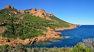
The Massif de l'Esterel is a Mediterranean coastal mountain range in the departments of Var and Alpes-Maritimes on the French Riviera. Neighbouring cities are Mandelieu-la-Napoule and Cannes on the east, as well as Saint-Raphaël and Fréjus on the west.
Nice-Ville station, also known as Nice-Thiers station, is the main railway station of Nice, France. It is situated on the Marseille–Ventimiglia railway and constitutes the southwestern terminus of the Nice–Breil-sur-Roya railway. Nice-Ville is served by TER, Intercités and TGV services, as well as the Gare Thiers stop on Line 1 of the Nice tramway.
Montauroux is a commune in the Var department in the Provence-Alpes-Côte d'Azur region in Southeastern France.
The A8 autoroute, also known as La Provençale, is a 224-kilometer (139 mi)-long highway in France that runs between Aix-en-Provence and the A7 to the Côte d'Azur.
Les Adrets-de-l'Estérel is a commune in the department of Var in the Provence-Alpes-Côte d'Azur Region of southeastern France.
Tourrettes is a commune in the Var department in the Provence-Alpes-Côte d'Azur region in southeastern France.
The Marseille–Ventimiglia railway is a French-Monégasque-Italian 259-kilometre-long (161 mi) railway line. It opened in several stages between 1858 and 1872.
National road RN 98 is a French road. In its latest form, it connects Toulon to Menton. It also passes through Monaco.
Estérel Côte d'Azur Agglomération is a communauté d'agglomération, an intercommunal structure, centred on the cities of Fréjus and Saint-Raphaël. It is located in the Var department, in the Provence-Alpes-Côte d'Azur region, southeastern France. It was created in January 2013. Its seat is in Saint-Raphaël. Its population was 112,812 in 2017.
Agay is a village district of Saint-Raphaël in the south-east of France in the Var department in the Provence-Alpes-Côte d'Azur region. Agay is located directly on the coast of the Côte d'Azur.
Esterellite is a porphyritic variety of quartz-bearing microdiorite, containing phenocrysts of quartz, zoned andesine, and hornblende only found in the southern part of the Esterel massif, between Agay and Saint-Raphael, France. It is a bluish-grey rock, sometimes greenish, dotted with white plagioclase feldspar and amphibiole crystals, forming a thick laccolithic complex near Le Drammont.