
Bangladesh is a densely populated, low-lying, mainly riverine country located in South Asia with a coastline of 580 km (360 mi) on the northern littoral of the Bay of Bengal. The delta plain of the Ganges (Padma), Brahmaputra (Jamuna), and Meghna Rivers and their tributaries occupy 79 percent of the country. Four uplifted blocks occupy 9 percent and steep hill ranges up to approximately 1,000 metres (3,300 ft) high occupy 12 percent in the southeast and in the northeast. Straddling the Tropic of Cancer, Bangladesh has a tropical monsoon climate characterised by heavy seasonal rainfall, high temperatures, and high humidity. Natural disasters such as floods and cyclones accompanied by storm surges periodically affect the country. Most of the country is intensively farmed, with rice the main crop, grown in three seasons. Rapid urbanisation is taking place with associated industrial and commercial development. Exports of garments and shrimp plus remittances from Bangladeshis working abroad provide the country's three main sources of foreign exchange income.
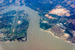
The Karnaphuli River is the largest and most important river in Chittagong and the Chittagong Hill Tracts. It is a 667-metre (2,188 ft) wide river in the south-eastern part of Bangladesh. Originating from the Saithah village of Mamit district in Mizoram, India, it flows 270 kilometres (170 mi) southwest through Chattogram Hill Tracts and Chattogram into the Bay of Bengal. It is the fastest flowing river in Bangladesh, after the Padma. It is said to "represent the drainage system of the whole south-western part of Mizoram." Principal tributaries include the Kawrpui River or Thega River, Tuichawng River and Phairuang River. A large hydroelectric power plant was built on the Karnaphuli in the Kaptai region in the 1960s. The mouth of the river hosts the Port of Chattogram, the largest and busiest seaport of Bangladesh.
Rangamati District is a district in south-eastern Bangladesh. It is a part of the Chattogram Division, and the town of Rangamati serves as the headquarters of the district. By area, Rangamati is the largest district of the country.

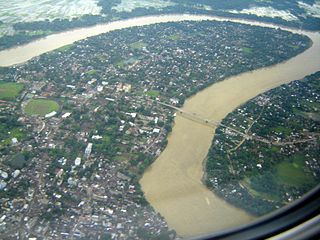
Rangamati (Bengali: রাঙ্গামাটি is the administrative headquarter and town of Rangamati District in the Chittagong Hill Tracts of Bangladesh. The town is located at 22°37'60N 92°12'0E and has an altitude of 14 metres. It was the capital of the Chakma kingdom during the British rule in Chittagong hill tracts.
The Barak River or Barbakro flows 900 kilometres (560 mi) through the states of Manipur, Mizoram and Assam in India. It flows into Bangladesh where it bifurcates into the Surma river and the Kushiyara river which converge again to become the Meghna river before forming the Ganges Delta. Of its total length, 524 km (326 mi) is in India, 31 km (19 mi) in Bangladesh. The upper part of its navigable part is in India — 121 km (75 mi) between Lakhipur and Bhanga, declared as National Waterway 6, (NW-6) since the year 2016. It drains a basin of 52,000 km2 (20,000 sq mi), of which 41,723 km2 (16,109 sq mi) lies in India, 1.38% (rounded) of the country. The water and banks host or are visited by a wide variety of flora and fauna.
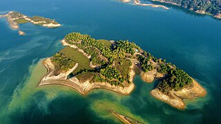
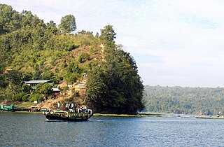
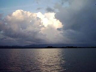
Kaptai Lake is the largest man-made lake in Bangladesh. It is located in the Kaptai Upazila under Rangamati District of Chittagong Division. The lake was created as a result of building the Kaptai Dam on the Karnaphuli River, as part of the Karnafuli Hydropower Station. Kaptai Lake's average depth is 100 feet (30 m) and maximum depth is 175 feet (53 m).

Tlabung, formerly known as Demagiri, is a census town in Lunglei district in the Indian state of Mizoram.
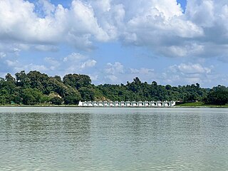
Kaptai Dam is on the Karnaphuli River at Kaptai, 65 km (40 mi) upstream from Chittagong in Rangamati District, Bangladesh. It is an earth-fill embankment dam with a reservoir with water storage capacity of 6,477 million cubic metres (5,251,000 acre⋅ft). The primary purpose of the dam and reservoir was to generate hydroelectric power. Construction was completed in 1962, in then-East Pakistan. The generators in the 230 MW (310,000 hp) Karnafuli Hydroelectric Power Station were commissioned between 1962 and 1988. It is the only hydroelectric power station in Bangladesh.
Baghaichhari is an upazila of Rangamati District in the division of Chittagong, Bangladesh.
Barkal is an upazila (sub-district) of Rangamati District in the Division of Chittagong, Bangladesh. Tribal people call it as Borhol বড়হল.
Belaichhari is an upazila of Rangamati District in the division of Chittagong, Bangladesh.
Kaptai is an upazila of Rangamati District in the Division of Chittagong, Bangladesh. The name of the Kaptai was derived from the Tripuri word "Kaptetoima". It is said that in the past days, the riverine was so wild and full of tropical flora and fauna. A huge amount of several verities of canes used to be found throughout the course of the river that flows from the south, upper ridge, and the river makes its estuary into the Kainsa Khyong.

The state of Maharashtra in India has several major river systems including those of the Narmada, Tapti, Godavari and Krishna rivers. The ecology of these rivers and associated wetlands is covered in this article.

Tourism in Bangladesh includes tourism to World Heritage Sites, historical monuments, resorts, beaches, picnic spots, forests, tribal people, and wildlife of various species. Activities for tourists include angling, water skiing, river cruising, hiking, rowing, yachting, beachgoing and sea bathing.
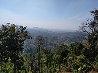
Mizoram is a land of rolling hills, valleys, rivers, and lakes in Northeast India. As many as 21 major hill ranges or peaks of different heights run through the length and breadth of the state, with plains scattered here and there. The average height of the hills to the west of the state is about 1,000 metres. These gradually rise to 1,300 metres to the east. Some areas, however, have higher ranges which go up to a height of over 2,000 metres.
Kaptai National Park is a national park in Bangladesh situated in Rangamati District. It was established in 1999 and its area is 5,464.78 hectares. Prior to the declaration of the national park, it was known as Sitapahar Reserve. The original Sitapahar Reserve area was 14,448.0 acres. Out of this an area of 100 acres have been dereserved for the establishment of the industrial estate at Kaptai. It is about 57 kilometre from Chittagong city. It comprises with two Ranges namely Kaptai Range and Karnaphuli Range. Kaptai National park is managed under CHT South Forest Division. It is historically important because teak plantations in Bangladesh were started from this area. Its forest type is mixed evergreen forest. In 2009 IPAC project started its activities in this protected area.

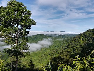
Sajek Valley is a popular tourist spot in Bangladesh, situated among the hills of the Kasalong range of mountains in the northern area of the Chittagong Hill Tracts. Referred to as the "Queen of Hills" and the "Roof of Rangamati", the valley is known for its greenery and dense forests, situated at an elevation of 1,800 feet (550 m) above sea level.
Pablakhali Wildlife Sanctuary is a wildlife sanctuary at the northern end of the Kaptai reservoir in the Chittagong Hill Tracts region of Bangladesh. The area of the sanctuary is 42,087 ha, and it is located on the eastern and northern hills of Bangladesh. The nearest town is Rangamati (Bengali: রাঙ্গামাটি which is 112 km from the sanctuary. The western boundary of the sanctuary is formed by the Kassalong River.
Kassalang reserve forest is an evergreen mountainous forest in Bangladesh. It covers an area of 1485 km2. It is a protected area in Bangladesh. Kassalang reserve forest is one of the largest and dense forest in Bangladesh. The area of Kassalang is situated far away from human settlements that make it special for nature lovers. It houses Bangladesh's richest wildlife resource after Sundarbans and Sangu Matamuhari. It is under the Baghaichari. Forest Division of the Forest Department (Bangladesh). It is a 9a bio-ecological zone in Chittagong Hill Tracts.
The Karnaphuli Hydropower Station, commonly referred to as the Kaptai Hydroelectric Power Station, is a hydroelectric power generating facility situated in Kaptai Upazila, Rangamati District, within the Chittagong Division of Bangladesh. This power station was constructed by building a dam across the Karnaphuli River, harnessing the power of flowing water to generate electricity।