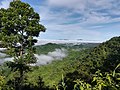
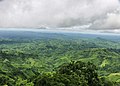
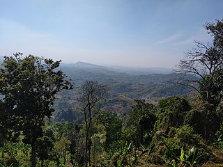
The ChattogramHill Tracts, often shortened to simply the Hill Tracts and abbreviated to CHT, are a group of districts within the Chittagong Division in southeastern Bangladesh, bordering India and Myanmar (Burma) in the east. Covering 13,295 square kilometres (5,133 sq mi), they formed a single district until 1984, when they were divided into three districts: Khagrachhari, Rangamati, and Bandarban.

Chittagong Division, officially known as Chattogram Division, is geographically the largest of the eight administrative divisions of Bangladesh. It covers the south-easternmost areas of the country, with a total area of 34,529.97 km2 (13,332.10 sq mi) and a population at the 2022 census of 33,202,326. The administrative division includes mainland Chittagong District, neighbouring districts and the Chittagong Hill Tracts.
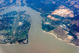
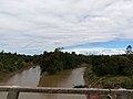
The Karnaphuli River is the largest and most important river in Chittagong and the Chittagong Hill Tracts. It is a 667-metre (2,188 ft) wide river in the south-eastern part of Bangladesh. Originating from the Saithah village of Mamit district in Mizoram, India, it flows 270 kilometres (170 mi) southwest through Chattogram Hill Tracts and Chattogram into the Bay of Bengal. It is the fastest flowing river in Bangladesh, after the Padma. It is said to "represent the drainage system of the whole south-western part of Mizoram." Principal tributaries include the Kawrpui River or Thega River, Tuichawng River and Phairuang River. A large hydroelectric power plant was built on the Karnaphuli in the Kaptai region in the 1960s. The mouth of the river hosts the Port of Chattogram, the largest and busiest seaport of Bangladesh.
Munshi Abdur Rouf BS was a Lance Nayek in the 11th Wing of East Pakistan Rifles during the Bangladesh Liberation War. He enlisted in the East Pakistan Rifles on 8 May 1963, and was attached with a regular infantry unit during the War of Liberation. Rouf died on 8 April 1971 at Burighat in Chittagong Hill Tracts after causing extensive damage to the Pakistani Army with his machine gun and forcing them to retreat. He was buried at Naniarchor Upazila in Rangamati District.

The Chakma people or Changhma people (Chakma:𑄌𑄋𑄴𑄟𑄳𑄦), are an ethnic group from the eastern-most regions of the Indian subcontinent and Western Myanmar. They are the largest ethnic group of the Chittagong Hill Tracts region of southeastern Bangladesh, and the largest in the Chakma Autonomous District Council of Mizoram, India. Significant Chakma populations are found in the northeast Indian states of Arunachal Pradesh, Tripura and Assam.
Rangamati Hill District is a district in south-eastern Bangladesh. It is a part of the Chattogram Division, and the town of Rangamati serves as the headquarters of the district. By area, Rangamati is the largest district of the country.

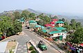
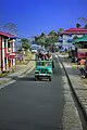
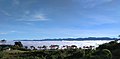
Rangamati is the administrative headquarter and town of Rangamati Hill District in the Chittagong Hill Tracts of Bangladesh. The town is located at 22°37'60N 92°12'0E and has an altitude of 14 metres (46 ft). It is also where Ropuiliani, a Mizo chieftess, was jailed and died, during British rule in Mizoram.

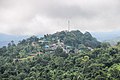
Bandarban is a district in South-Eastern Bangladesh, and a part of the Chittagong Division. It is one of the three hill districts of Bangladesh and a part of the Chittagong Hill Tracts, the others being Rangamati District and Khagrachhari District. Bandarban district (4,479 km2) is not only the most remote district of the country, but also the least populous. There is an army contingent at Bandarban Cantonment.
Khagrachari is a district in the Chittagong Division of Southeastern Bangladesh. It is a part of the Chittagong Hill Tracts region.

Tlabung, formerly known as Demagiri, is a census town in Lunglei district in the Indian state of Mizoram.

Jampui Hills is a part of the Mizo hills range located in the North Tripura district in the north eastern part of the Indian state of Tripura. The average altitude of the hill range is approximately 1000 metres above sea level.

Dighinala is an upazila of Khagrachari District in the Division of Chittagong, Bangladesh.

Tourism in Bangladesh includes tourism to World Heritage Sites, historical monuments, resorts, beaches, picnic spots, forests, tribal people, and wildlife of various species. Activities for tourists include angling, water skiing, river cruising, hiking, rowing, yachting, beachgoing and sea bathing.
Raja Nalinaksha Roy was the 49th Raja of the Chakma Circle.
Khagrachhari Hill District Council is the local government council responsible for the administration of Khagrachhari District, Bangladesh. The chairman of the council is Kongjari Chowdhury.
Rangamati Hill District Council is the autonomous government body responsible for the governance of Rangamati Hill District. Aung Sui Pru Chowdhury is the Chairman of the Rangamati Hill District Council.

The Mong Circle is one of three hereditary chiefdoms in the Chittagong Hill Tracts of modern-day Bangladesh. The jurisdiction of the Mong Circle encompasses parts of Khagrachhari District. The chiefdom's members are of Marma descent and are known as phalansa. Most inhabitants of the Mong Circle settled in the northwest during a migration wave from the Kingdom of Mrauk U between the 16th and 18th centuries, while inhabitants of the other Marma chiefdom, the Bohmong Circle settled in the south and are known as ragraisa.
The Sajek River, also known as the Kasalong River, is a waterway that runs through the Chittagong Hill Tracts in Bangladesh and borders the Indian state of Mizoram. The river provides a vital role in drawing the border between India and Bangladesh. It is a lifeline for the communities living in the Sajek Valley, named after the river, and the surrounding areas. The river originates from the Karnaphuli River.
Kassalang reserve forest is an evergreen mountainous forest in Bangladesh. It covers an area of 1485 km2. It is a protected area in Bangladesh. Kassalang reserve forest is one of the largest and dense forest in Bangladesh. The area of Kassalang is situated far away from human settlements that make it special for nature lovers. It houses Bangladesh's richest wildlife resource after Sundarbans and Sangu Matamuhari. It is under the Baghaichari. Forest Division of the Forest Department (Bangladesh). It is a 9a bio-ecological zone in Chittagong Hill Tracts.