Salcedo, Dominican Republic

Last updated
Salcedo
Escudo del Municipio Salcedo.jpg
Dominican Republic relief location map.jpg
Red pog.svg
Salcedo
Coordinates: 19°22′41″N70°25′05″W / 19.378°N 70.418°W / 19.378; -70.418 ,
CountryFlag of the Dominican Republic.svg  Dominican Republic
Province Hermanas Mirabal
Area
[1]
  Total
190.6 km2 (73.6 sq mi)
Elevation
[2]
196 m (643 ft)
Population
 (2012) [3]
  Total
45,299
  Density240/km2 (620/sq mi)
  Demonym
Salcedense
Distance to
 Santo Domingo

160 km
Municipalities 1

Salcedo is the capital city of the Hermanas Mirabal Province in the Dominican Republic. It is the birthplace of the Dominican heroines, the Mirabal sisters, who died in the struggle against the dictator Rafael Trujillo. A museum in the town commemorates three of sisters; it was tended to by the remaining sister, Bélgica (Dedé) Mirabal, until her death on February 1, 2014. [4]

Contents

The city is named after Francisco Antonio Salcedo who fought in the northwestern part of the country against the Haitian army during the Dominican-Haitian War after the Dominican independence from Haiti in 1844.

Geography

Salcedo is located in the Cibao Valley, south of the Cordillera Septentrional (in English, "Northern mountain range"). It has a total area of 432.95 km2. [1] It has only one municipal district (a subdivision of a municipality): Jamao Afuera. [5]

Climate

Climate data for Salcedo, Dominican Republic (1961-1990)
MonthJanFebMarAprMayJunJulAugSepOctNovDecYear
Record high °C (°F)35.3
(95.5)
35.7
(96.3)
36.8
(98.2)
37.3
(99.1)
37.6
(99.7)
39.4
(102.9)
39.5
(103.1)
38.7
(101.7)
37.1
(98.8)
37.1
(98.8)
36.5
(97.7)
36.0
(96.8)
39.5
(103.1)
Mean daily maximum °C (°F)29.1
(84.4)
29.4
(84.9)
30.7
(87.3)
31.3
(88.3)
31.7
(89.1)
32.5
(90.5)
32.5
(90.5)
32.5
(90.5)
32.8
(91.0)
32.1
(89.8)
30.7
(87.3)
29.1
(84.4)
31.2
(88.2)
Mean daily minimum °C (°F)18.7
(65.7)
18.8
(65.8)
19.4
(66.9)
19.9
(67.8)
20.7
(69.3)
21.5
(70.7)
21.4
(70.5)
21.3
(70.3)
21.1
(70.0)
20.7
(69.3)
19.8
(67.6)
19.0
(66.2)
20.2
(68.4)
Record low °C (°F)13.5
(56.3)
14.0
(57.2)
14.0
(57.2)
14.1
(57.4)
15.0
(59.0)
16.1
(61.0)
16.5
(61.7)
17.0
(62.6)
16.3
(61.3)
16.2
(61.2)
15.7
(60.3)
15.0
(59.0)
13.5
(56.3)
Average rainfall mm (inches)82.7
(3.26)
73.2
(2.88)
75.7
(2.98)
107.5
(4.23)
152.7
(6.01)
79.1
(3.11)
108.9
(4.29)
131.0
(5.16)
113.4
(4.46)
124.7
(4.91)
157.9
(6.22)
134.2
(5.28)
1,341
(52.80)
Average rainy days (≥ 1.0 mm)10.88.58.68.811.68.812.111.59.811.212.813.3127.8
Source: NOAA [6]

History

In the place where is now the city of Salcedo there was a very small town with the name of Juana Núñez. It was made a Puesto cantonal (an old category that now is called Municipal District) in 1880 as part of the old La Vega province. [7]

With the creation of the Espaillat province in 1885, Juana Núñez was made part of this new province. In 1891, its name was changed from Juana Núñez to the present one, Salcedo.

Salcedo was made a municipality in 1905 and, when the Salcedo Province (now Hermanas Mirabal Province) was created in 1952, the city became the head municipality of the new province.

Economy

Farming is the only economic activity in the municipality, except for some very small industries; the main products are plantain, cassava and cacao.

Sister cities

Interesting facts

The city became widely known outside of the Dominican Republic due to the YouTube video with an unusual request from the listener of a local radio station to play a song with the words "Esas son Reebok o son Nike" (meaning "Are they Reebok or Nike?"). The song in reference was actually Corona's "The Rhythm of the Night".

Related Research Articles

<span class="mw-page-title-main">Santo Domingo</span> Capital and largest city of the Dominican Republic

Santo Domingo, once known as Santo Domingo de Guzmán, known as Ciudad Trujillo between 1936 and 1961, is the capital and largest city of the Dominican Republic and the largest metropolitan area in the Caribbean by population. As of 2022, the city and immediate surrounding area had a population of 1,029,110 while the total population is 3,798,699 when including Greater Santo Domingo. The city is coterminous with the boundaries of the Distrito Nacional, itself bordered on three sides by Santo Domingo Province.

<span class="mw-page-title-main">San Cristóbal Province</span> Province of the Dominican Republic

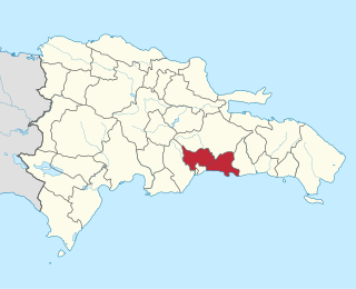
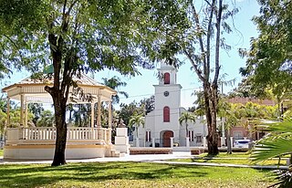
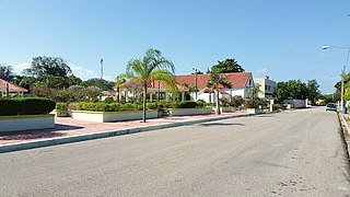
San Cristóbal is a province in the southern region of Dominican Republic, located west of the capital Santo Domingo. With approximately 642,000 inhabitants, it is the fourth most populated province in the country, only behind Santo Domingo, Santiago and the National District. It borders the provinces Monseñor Nouel (north), Monte Plata (northeast), Santo Domingo (east), Peravia (west) and San José de Ocoa (northwest). The Caribbean Sea borders the province to the south. The provincial capital is the city of San Cristóbal.

<span class="mw-page-title-main">Mirabal sisters</span> Dominican political protestors, assassinated in 1960

The Mirabal sisters were four sisters from the Dominican Republic, three of whom opposed the dictatorship of Rafael Trujillo and were involved in activities against his regime. The three sisters were assassinated on 25 November 1960. The last sister, Adela, commonly known as Dedé, who was not involved in political activities at the time, died of natural causes on 1 February 2014.

<span class="mw-page-title-main">Provinces of the Dominican Republic</span> First-level administrative divisions of the Dominican Republic

The Dominican Republic is divided into thirty-one provincias, while the national capital, Santo Domingo, is contained within its own Distrito Nacional.

<span class="mw-page-title-main">Dajabón Province</span> Province of the Dominican Republic

Dajabón is a northwestern province which currently comprises one of the 32 provinces of the Dominican Republic. It is divided into 5 municipalities and its capital city with the same name. It is bordered by the provinces of Monte Cristi to the north, Santiago Rodríguez to the south, Elías Piña to the south and the Nord-Est department of Haiti to the west.

<span class="mw-page-title-main">Duarte Province</span> Province of the Dominican Republic

Duarte is a northeastern province which comprises one of the 32 provinces of the Dominican Republic. It is divided into 7 municipalities and its capital city is San Francisco de Macorís. It is bordered by the provinces of María Trinidad Sánchez and Samaná to the east, Monte Plata and Sánchez Ramírez to the south, La Vega and Hermanas Mirabal to the west and Espaillat to the north. It is named after Juan Pablo Duarte, the founder of the Dominican Republic.

<span class="mw-page-title-main">La Vega Province</span> Province of the Dominican Republic

La Vega is one of the 32 provinces of the Dominican Republic. It is located in the Cibao Valley, the north-central region of the country, and is divided into 4 municipalities with its capital city being the namesake of La Vega. The province borders Espaillat and Hermanas Mirabal to the north, Duarte to the east, Monseñor Nouel to the south and Santiago to the west.

<span class="mw-page-title-main">Monte Cristi Province</span> Province of the Dominican Republic

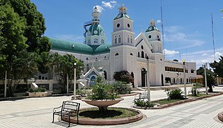
Monte Cristi is a province in the northwest of the Dominican Republic. The capital city is San Fernando de Monte Cristi. The spelling Montecristi is also seen. The Montecristi province is located in the Cibao frontier region, on the north coast of the country and borders the nation of Haiti. The land area of the Montecristi province is 1,924.35 km2. It is divided into six municipalities and four municipal districts.

<span class="mw-page-title-main">Monte Plata Province</span> Province of the Dominican Republic

Monte Plata is an eastern province of the Dominican Republic, and also the name of its capital city. It was split from San Cristóbal in 1992.

<span class="mw-page-title-main">Hermanas Mirabal Province</span> Province of the Dominican Republic

Hermanas Mirabal is a province of the Dominican Republic. It was split from Espaillat Province in 1952 and was originally called Salcedo, the name of its capital city; it is still referred to by this name sometimes.

<span class="mw-page-title-main">Santo Domingo Province</span> Province of the Dominican Republic

Santo Domingo is a province of the Dominican Republic. It was split from the Distrito Nacional on October 16, 2001.

<span class="mw-page-title-main">Comendador, Dominican Republic</span> Place in Elías Piña, Dominican Republic

Comendador is the capital of the Elías Piña province of the Dominican Republic. It has a border crossing to the Haitian town Belladère.

<span class="mw-page-title-main">Dajabón</span> Place in Dominican Republic

Dajabón is a municipality and capital of the Dajabón province in the Dominican Republic, which is located on the northwestern Dominican Republic frontier with Haiti. It is a market town with a population of about 26,000, north of the Cordillera Central mountain range.

<span class="mw-page-title-main">Bánica</span> Place in Elías Piña, Dominican Republic

San Francisco de Bánica, or simply Bánica, is a town and municipality in the northwest region of Dominican Republic in the Elías Piña province. It is located on the border with Haiti near the Artibonite river. The name Bánica comes from the Taíno name of the region, Banique.

Santo Domingo Norte is a municipality of the Santo Domingo Province in the Dominican Republic. There is one municipal district within the municipality: La Victoria.

<span class="mw-page-title-main">San Juan de la Maguana</span> Place in San Juan, Dominican Republic

San Juan de la Maguana is a city and municipality in the western region of the Dominican Republic and capital of the San Juan province. It was one of the first cities established on the island; founded in 1503, and was given the name of San Juan de la Maguana by San Juan Bautista and the Taino name of the valley: Maguana. The term Maguana means "the first stone, the unique stone".

Hondo Valle is a town in the Elías Piña province of the Dominican Republic characterized by its beautiful mountains and cold climate.

<span class="mw-page-title-main">Jaime David Fernández Mirabal</span> Politician from the Dominican Republic

Dr. Jaime David Fernandez Mirabal is a Dominican psychiatrist, agronomist, and politician.

References

  1. 1 2 Superficies a nivel de municipios, Oficina Nacional de Estadistica Archived 2009-04-17 at the Wayback Machine
  2. De la Fuente, Santiago (1976). Geografía Dominicana (in Spanish). Santo Domingo, Dominican Republic: Editora Colegial Quisqueyana.
  3. Censo 2012 de Población y Vivienda, Oficina Nacional de Estadistica
  4. Garcia, Franklin (2014-02-03). "Last Surviving Mirabal Sister, Doña Dede, Dead at 88". Huffington Post. Retrieved 2018-08-01.
  5. Oficina Nacional de Estadística. "División Territorial 2008" (in Spanish). Archived from the original (PDF) on 2010-04-14. Retrieved 2009-10-01.
  6. "Salcedo Climate Normals 1961-1990". National Oceanic and Atmospheric Administration. Retrieved September 19, 2016.
  7. Pouerié Cordero, M.M (1997). Síntesis de ciudades, pueblos e islas del país (in Spanish). Santo Domingo, Dominican Republic: Impresora Mary.