Saline Branch

Last updated
Saline Branch Drainage Ditch
Location
Physical characteristics
Source 
 - location Champaign County, Illinois south of Rantoul, Illinois
 - coordinates 40°15′59″N88°10′28″W / 40.266358°N 88.17433°W / 40.266358; -88.17433 (Saline Branch Drainage Ditch origin) [1]
Mouth  
 - location
Confluence with the Salt Fork Vermilion River west of St. Joseph, Illinois
 - coordinates
40°07′02″N88°03′08″W / 40.1173°N 88.0521°W / 40.1173; -88.0521 (Saline Branch Drainage Ditch mouth) Coordinates: 40°07′02″N88°03′08″W / 40.1173°N 88.0521°W / 40.1173; -88.0521 (Saline Branch Drainage Ditch mouth) [1]
 - elevation
676 ft (206 m)
Basin features
ProgressionSaline Branch → Salt ForkVermilionWabashOhioMississippiGulf of Mexico
Tributaries 
 - right Boneyard Creek
GNIS ID 417889
Map all coordinates using: OpenStreetMap  
Download coordinates as: KML  ·  GPX

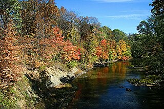
The Saline Branch, or Saline Branch Ditch, is a tributary of the Vermilion River in east central Illinois. [2] It drains a parcel of east-central Champaign County, including most of the city of Urbana, Illinois and the University of Illinois campus within Urbana. [3]

Tributary stream or river that flows into a main stem river or lake

A tributary or affluent is a stream or river that flows into a larger stream or main stem river or a lake. A tributary does not flow directly into a sea or ocean. Tributaries and the main stem river drain the surrounding drainage basin of its surface water and groundwater, leading the water out into an ocean.

Vermilion River (Wabash River) tributary of the Wabash River in Illinois and Indiana, United States

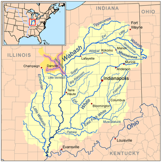
The Vermilion River is a tributary of the Wabash River in the states of Illinois and Indiana, United States.

Illinois State of the United States of America

Illinois is a state in the Midwestern and Great Lakes region of the United States. It has the fifth largest gross domestic product (GDP), the sixth largest population, and the 25th largest land area of all U.S. states. Illinois is often noted as a microcosm of the entire United States. With Chicago in northeastern Illinois, small industrial cities and immense agricultural productivity in the north and center of the state, and natural resources such as coal, timber, and petroleum in the south, Illinois has a diverse economic base, and is a major transportation hub. Chicagoland, Chicago's metropolitan area, encompasses over 65% of the state's population. The Port of Chicago connects the state to international ports via two main routes: from the Great Lakes, via the Saint Lawrence Seaway, to the Atlantic Ocean and from the Great Lakes to the Mississippi River, via the Illinois Waterway to the Illinois River. The Mississippi River, the Ohio River, and the Wabash River form parts of the boundaries of Illinois. For decades, Chicago's O'Hare International Airport has been ranked as one of the world's busiest airports. Illinois has long had a reputation as a bellwether both in social and cultural terms and, through the 1980s, in politics.

Extensive engineering work from the late 1800s through the early 1900s, completed in 1908, straightened and ditched the once-wandering creek. It discharges into the Salt Fork of the Vermilion River; the discharge includes outflow from the Urbana-Champaign Sanitary District. The U.S. Geographic Names Information System (GNIS) states an alternate name for this stream is West Branch Salt Fork. [2]

Salt Fork Vermilion River river in the United States of America

The Salt Fork is a tributary of the Vermilion River located in Illinois.

Geographic Names Information System geographical database

The Geographic Names Information System (GNIS) is a database that contains name and locative information about more than two million physical and cultural features located throughout the United States of America and its territories. It is a type of gazetteer. GNIS was developed by the United States Geological Survey in cooperation with the United States Board on Geographic Names (BGN) to promote the standardization of feature names.

Related Research Articles

Vermilion County, Illinois County in the United States

Vermilion County is a county in the eastern part of the U.S. state of Illinois, between the Indiana border and Champaign County. It was established in 1826 and was the 45th of Illinois' 102 counties. According to the 2010 United States Census, it had a population of 81,625, a decrease of 2.7% in 2000. It contains 21 incorporated settlements; the county seat and largest city is Danville.

Champaign County, Illinois County in the United States

Champaign County is a county in the U.S. state of Illinois. As of the 2010 census, its population was 201,081, making it the 10th-most populous county in Illinois. Its county seat is Urbana.

Dirty Devil River river in the United States of America

The Dirty Devil River is an 80-mile-long (130 km) tributary of the Colorado River, located in the U.S. state of Utah. It flows through southern Utah from the confluence of the Fremont River and Muddy Creek before emptying into the Colorado River at Lake Powell.

Paria River river in southern Utah and northern Arizona

The Paria River is a tributary of the Colorado River, approximately 95 miles (153 km) long, in southern Utah and northern Arizona in the United States. It drains a rugged and arid region northwest of the Colorado, flowing through roadless slot canyons along part of its course.

Lewis River (Washington) river in the United States of America

The Lewis River is a tributary of the Columbia River, about 95 miles (153 km) long, in southwestern Washington in the United States. It drains part of the Cascade Range north of the Columbia River. The drainage basin of the Lewis River covers about 1,046 square miles (2,709 km2). The river's mean annual discharge is about 6,125 cubic feet per second (173.4 m3/s). Unlike nearby Lewis County and Fort Lewis the Lewis River was not named for Meriwether Lewis, but rather for A. Lee Lewis, an early settler who homesteaded near the mouth of the river.

Vermilion River (Ohio) river in northern Ohio, United States of America

The Vermilion River is a river in northern Ohio in the United States. It is 66.9 miles (107.7 km) long and is a tributary of Lake Erie, draining an area of 268 square miles (690 km2). The name alludes to the reddish clay that is the predominant local soil along its route. The river is commonly muddy after rains.

Embarras River (Illinois) river in the United States of America

The Embarras River is a 195-mile-long (314 km) tributary of the Wabash River in southeastern Illinois in the United States. The waters of the Embarras reach the Gulf of Mexico via the Wabash, Ohio, and Mississippi Rivers. The river drains a watershed around 1,566,450 acres (6,339.2 km2) in an agricultural region. The name comes from French explorers, who used the term embarras for river obstacles, blockages, and difficulties relating to logjams and the like.

Saline River (Illinois) river in Illinois, United States of America

The Saline River is a tributary of the Ohio River, approximately 27 miles (43 km) long, in the Southern Illinois region of the U.S. state of Illinois. The river drains a large section of southeast Illinois, with a drainage basin of 1,762 square miles (4,564 km2). The major tributaries include the South Fork, Middle Fork and North Fork, all lying within the Saline Valley. The once meandering swampy river was important among Native Americans and early settlers as a source of salt from numerous salt springs where it was commercially extracted in the early 19th century.

Boneyard Creek creek through Champaign and Urbana, Illinois, USA

Boneyard Creek is a 3.3-mile-long (5.3 km) waterway that drains much of the cities of Champaign and Urbana, Illinois. It is a tributary of the Saline Branch of the Salt Fork Vermilion River, which is a tributary of the south-flowing Vermilion River and the Wabash River. The creek flows through the northern sections of the campus of the University of Illinois at Urbana-Champaign. The newsletter of the university's ACM chapter is Banks of the Boneyard, named after the creek.

The Little Vermilion River is a 59.6-mile-long (95.9 km) tributary of the Wabash River. The Little Vermilion rises in southern Vermilion County, Illinois, flowing eastward past Georgetown, Illinois, into Vermillion County, Indiana, where it joins the Wabash near Newport.

Middle Fork Vermilion River river in the United States of America

The Middle Fork of the Vermilion River is a tributary of the Vermilion River in Illinois. The Middle Fork rises in Ford County and flows southeast to join the Vermilion near Danville.

Sidney Township, Champaign County, Illinois Township in Illinois, United States

Sidney Township is a township in Champaign County, Illinois, USA. As of the 2010 census, its population was 1,733 and it contained 715 housing units.

Urbana Township, Champaign County, Illinois Township in Illinois, United States

Urbana Township is a township in Champaign County, Illinois, USA. As of the 2010 census, its population was 7,451 and it contained 3,435 housing units.

North Fork Feather River river in the United States of America

The North Fork Feather River is a watercourse of the northern Sierra Nevada in the U.S. state of California. It flows generally southwards from its headwaters near Lassen Peak to Lake Oroville, a reservoir formed by Oroville Dam in the foothills of the Sierra, where it runs into the Feather River. The river drains about 2,100 square miles (5,400 km2) of the western slope of the Sierras. By discharge, it is the largest tributary of the Feather.

Clear Creek is a southern Illinois watercourse that rises in Jackson County and Union County, and discharges into the Mississippi River in Alexander County.

Clearwater River (Idaho) river in Idaho, United States

The Clearwater River is in the northwestern United States, in north central Idaho. Its length is 74.8 miles (120.4 km), it flows westward from the Bitterroot Mountains along the Idaho-Montana border, and joins the Snake River at Lewiston. In October 1805, the Lewis and Clark Expedition descended the Clearwater River in dugout canoes, putting in at "Canoe Camp," five miles (8 km) downstream from Orofino; they reached the Columbia Bar and the Pacific Ocean about six weeks later.

White River (Arizona) river in the United States of America

The White River is a 16-mile (26 km) tributary of the Salt River in the U.S. state of Arizona. Formed by two forks that drain part of the White Mountains, it begins in Navajo County and ends in Gila County, where it meets the Black River to form the Salt River.

References

  1. 1 2 Coordinates derived by sight from USGS National Map. Coordinates not provided by GNIS.
  2. 1 2 U.S. Geological Survey Geographic Names Information System: Saline Branch Drainage Ditch
  3. Illinois Atlas and Gazetteer. Freeport, Maine: DeLorme Mapping. 1991. ISBN   0-89933-213-7.