
San Luis Obispo County, officially the County of San Luis Obispo, is a county on the Central Coast of California. As of the 2010 census, the population was 269,637. The county seat is San Luis Obispo.

Cayucos is an unincorporated coastal town in San Luis Obispo County, California, along California State Route 1 between Cambria to the north and Morro Bay to the south. The population was 2,592 at the 2010 census, down from 2,943 at the 2000 census.

San Luis Obispo is a city and county seat of San Luis Obispo County, in the U.S. state of California. Located on the Central Coast of California, San Luis Obispo is roughly halfway between the Bay Area in the north and Greater Los Angeles in the south. The population was 47,063 at the 2020 census.

The Central Coast is an area of California, roughly spanning the coastal region between Point Mugu and Monterey Bay. It lies northwest of Los Angeles County and south of San Mateo and Santa Clara counties, and includes the rugged, undeveloped stretch of coastline known as Big Sur. From south to north, there are six counties that make up the Central Coast: Ventura, Santa Barbara, San Luis Obispo, Monterey, San Benito, and Santa Cruz.

Area codes 805 and 820 are California telephone area codes; 805 was originally split from area code 213 in 1957. They include most or all of the California counties of San Luis Obispo, Santa Barbara, Ventura, plus the southernmost portions of Monterey County.

Central California is generally thought of as the middle third of the state, north of Southern California, which includes Los Angeles, and south of Northern California, which includes San Francisco. It includes the northern portion of the San Joaquin Valley, part of the Central Coast, the central hills of the California Coast Ranges and the foothills and mountain areas of the central Sierra Nevada.

Estero Bay is a bay located on the Pacific Coast in San Luis Obispo County, central California. It is about 15 miles (24 km) from its south end at Point Buchon/Montana de Oro State Park, to its north end at Point Estero, which is about 5 miles (8 km) northwest of Cayucos. It is indented about 5 miles (8 km) into the California coast.

Atascadero High School is an American public high school located in Atascadero, California. Atascadero High School is 1 of 2 high schools in the Atascadero Unified School District. The school receives its students mainly from the Atascadero Junior High School and Atascadero Fine Arts Academy, and also attracts students from outlying areas of northern and eastern San Luis Obispo County. The mission of Atascadero High School is to provide educational opportunities which empower students to reach their fullest potential, and participate as responsible and productive citizens in a continuously changing world. All students have access to personal support services, activities, and opportunities, and have equal access to the school’s many programs.
The California Department of Forestry and Fire Protection is a fire department of the California Natural Resources Agency in California, United States. It is responsible for fire protection in various areas under state responsibility totaling 31 million acres, as well as the administration of the state's private and public forests. In addition, the department provides varied emergency services in 36 of the state's 58 counties via contracts with local governments. The department's director is Thom Porter, who was appointed by Governor of California Gavin Newsom.
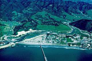
San Luis Obispo Creek is a stream, about 18 miles (29 km) long, in San Luis Obispo County, California. It drains a large coastal watershed that includes the city of San Luis Obispo, emptying into the Pacific Ocean at Avila Beach.

Cypress Ridge Golf Course is located in Arroyo Grande, California—which is on the Central Coast of California. The golf course is a Peter Jacobsen Signature Golf Course, designed by Jacobsen Hardy Design. In its design and conception, Jacobsen Hardy utilized the natural surroundings of the area to make this central coast golf course truly unique. The golf course opened in 1999. It is rated 4½ stars by Golf Digest "Best Places to Play".
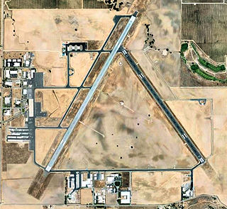
Paso Robles Municipal Airport is four miles (6 km) northeast of downtown Paso Robles, in San Luis Obispo County, California, United States.

L'Aventure, or Stephan Vineyards, is a California wine estate producing red wine blends of the Bordeaux and Rhône grape varieties. The winery is located southwest of Paso Robles, California, along the Pacific Coast in the Santa Lucia Mountain range.
Rancho Huerhuero was a 15,685-acre (63.47 km2) Mexican land grant in present day San Luis Obispo County, California of one square league given in 1842 by Governor Juan Alvarado and another three square leagues given in 1846 by Governor Pío Pico to José Mariano Bonilla. The grant extended along Huerhuero Creek and encompassed present day Creston southeast of Paso Robles.
The San Luis Obispo Regional Transit Authority is the provider of intercity mass transportation in San Luis Obispo County, California, with service between most cities in the county: Arroyo Grande, Atascadero, Paso Robles, Grover Beach, Morro Bay, Pismo Beach, Cambria, San Simeon, Los Osos, Cayucos, and San Luis Obispo. Hourly routes operate Monday - Friday, with more limited Saturday & Sunday service. The base travel fare is $1.50-$3 each way, or a Regional 24-Hour Pass may be purchased for $5, good for unlimited trips on all fixed-routes in the county. Five routes are branded as part of the SLORTA. RTA also operates fixed route transit service in the Five Cities Area for South County Transit and the Avila Beach Trolley on a seasonal runs.
Rancho Pismo was a 8,839-acre (35.77 km2) Mexican land grant in present day San Luis Obispo County, California, given in 1840 by acting governor Manuel Jimeno Casarin to José Ortega. The grant extended along the Pacific coast and encompassed present day Pismo Beach, Grover Beach, Shell Beach and parts of Arroyo Grande.
Rancho Santa Ysabel was a 17,774-acre (7,193 ha) Mexican land grant in present-day San Luis Obispo County, California given in 1844 by Governor Manuel Micheltorena to Francisco Arce. The grant was southeast of present-day Paso Robles, between the Salinas River on the west and Huerhuero Creek on the east.

Paso Robles, officially El Paso de Robles, is a city in San Luis Obispo County, California, United States. Located on the Salinas River north of San Luis Obispo, California, the city is known for its hot springs, its abundance of wineries, its production of olive oil, almond orchards, and for playing host to the California Mid-State Fair.
Adelaida District AVA is an American Viticultural Area located on the north west portion of the Paso Robles AVA in San Luis Obispo County, California. It was established by the Alcohol and Tobacco Tax and Trade Bureau in 2014. Wineries located within the Adelaida District are: The Farm Winery, Peachy Canyon Winery, Le Cuvier, Alta Colina, Carmody McKnight Estate Wines, Wild Coyote, Villicana, McPrice Myers, Jacob Toft, Chronic Cellars, Vines on the Marycrest, Lone Madrone, Adelaida Cellars, DAOU, Calcareous, Law Estate, Nadeau, Minassian Young, Michael Gill, Villa Creek, Brecon, HammerSky, Oso Libre, Poallilo, Thacher Winery, Whalebone Vineyard, Tablas Creek Vineyard, Halter Ranch, Rangeland, Justin, Kukkula, Dubost, and Starr Ranch.

The Cuesta fire was a wildfire that started on 16 August 2015 near U.S. Route 101 and the Cuesta Grade, in the Santa Lucia Range just north of San Luis Obispo in San Luis Obispo County, California. The fire was contained on 28 August, and had burned 2,446 acres, some within the Los Padres National Forest.
