
Boyce Thompson Arboretum is the largest and oldest botanical garden in the state of Arizona. It is one of the oldest botanical institutions west of the Mississippi. Founded in 1924 as a desert plant research facility and “living museum”, the Arboretum is located in the Sonoran Desert on 392 acres along Queen Creek and beneath the towering volcanic remnant, Picketpost Mountain. Boyce Thompson Arboretum is on U.S. Highway 60, an hour's drive east from Phoenix and 3 miles (4.8 km) west of Superior, Arizona.

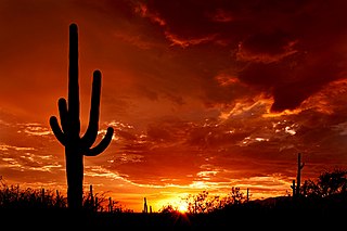
The Sonoran Desert is a North American desert and ecoregion which covers large parts of the Southwestern United States in Arizona and California and of Northwestern Mexico in Sonora, Baja California, and Baja California Sur. It is the hottest desert in Mexico. It has an area of 260,000 square kilometers (100,000 sq mi). The western portion of the United States–Mexico border passes through the Sonoran Desert.

The Chihuahuan Desert is a desert and ecoregion designation covering parts of northern Mexico and the southwestern United States. It occupies much of West Texas, the middle and lower Rio Grande Valley, the lower Pecos Valley in New Mexico, and a portion of southeastern Arizona, as well as the central and northern portions of the Mexican Plateau. It is bordered on the west by the Sonoran Desert and the extensive Sierra Madre Occidental range, along with northwestern lowlands of the Sierra Madre Oriental range. On the Mexican side, it covers a large portion of the state of Chihuahua, along with portions of Coahuila, north-eastern Durango, the extreme northern part of Zacatecas, and small western portions of Nuevo León. With an area of about 501,896 km2 (193,783 sq mi), it is the largest desert in North America.

Camelback Mountain is a mountain in Phoenix, Arizona, United States. The English name is derived from its shape, which resembles the hump and head of a kneeling camel. The mountain, a prominent landmark of the Phoenix metropolitan area, is located in the Camelback Mountain Echo Canyon Recreation Area between the Arcadia neighborhood of Phoenix and the town of Paradise Valley. It is a popular recreation destination for hiking and rock climbing.

Cylindropuntia bigelovii, the teddy bear cholla(choy-ya), is a cholla cactus species native to Northwestern Mexico, and to the United States in California, Arizona, and Nevada.

The White Tank Mountain Regional Park is a large regional park located in west-central Maricopa County, Arizona. Encompassing 29,271 acres of desert and mountain landscape, it is the largest regional park in the county. The bulk of the White Tank Mountains range is located within the park's boundaries.

Pinnacle Peak is a granite summit located in Scottsdale, Arizona. The peak rises to an elevation of 3,169 feet (966 m). It is located within the 150-acre (61 ha) Pinnacle Peak Park, operated by the City of Scottsdale Park District. Part of the Sonoran Desert, the park is home to a variety of native desert flora and fauna. Hikers utilize a 1.75 mile trail to explore the area, though rock climbing skills are needed to reach the summit.

Oracle State Park is a state park of Arizona, USA, preserving 3,948 acres (1,598 ha) in the northeastern foothills of the Santa Catalina Mountains. The park is named after the nearby town of Oracle. Oracle State Park serves as a wildlife refuge, and is open every day from 9am - 5pm. In October 2011 Arizona State Parks agreed to reopen Oracle on a limited basis with a $40,000 budget if the park's Friends group can raise $21,000 in additional funds. The park has more than 15 miles (24 km) of hiking trails, including 7 miles (11 km) of the Arizona Trail.

Hells Canyon Wilderness is a 9,951-acre wilderness area in the U.S. state of Arizona. It is located approximately 25 miles (40 km) northwest of Phoenix in Maricopa and southeast Yavapai counties.
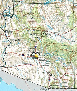
Arizona is a landlocked state situated in the southwestern region of the United States of America. It has a vast and diverse geography famous for its deep canyons, high- and low-elevation deserts, numerous natural rock formations, and volcanic mountain ranges. Arizona shares land borders with Utah to the north, the Mexican state of Sonora to the south, New Mexico to the east, and Nevada to the northwest, as well as water borders with California and the Mexican state of Baja California to the southwest along the Colorado River. Arizona is also one of the Four Corners states and is diagonally adjacent to Colorado.
Saguaro National Park is an American national park in Pima County, southeastern Arizona. The 92,000-acre (37,000 ha) park consists of two separate areas—the Tucson Mountain District (TMD) about 10 miles (16 km) west of the city of Tucson and the Rincon Mountain District (RMD) about 10 miles (16 km) east of the city—that preserve Sonoran Desert landscapes, fauna, and flora, including the giant saguaro cactus.

Joshua Tree National Park is an American national park in southeastern California, east of Los Angeles and San Bernardino, near Palm Springs. It is named for the Joshua trees native to the Mojave Desert. Originally declared a national monument in 1936, Joshua Tree was redesignated as a national park in 1994 when the U.S. Congress passed the California Desert Protection Act. Encompassing a total of 790,636 acres – slightly larger than the state of Rhode Island – the park includes 429,690 acres of designated wilderness. Straddling San Bernardino and Riverside Counties, the park includes parts of two deserts, each an ecosystem whose characteristics are determined primarily by elevation: the higher Mojave Desert and the lower Colorado Desert. The Little San Bernardino Mountains traverse the southwest edge of the park.

The Sawtooth Mountains Wilderness is a federal wilderness area of 32,136 acres (130.0 km2) located in the Sawtooth Mountains in eastern San Diego County, California. It is located in the Colorado Desert, 35 miles (56 km) south of Borrego Springs, near Anza Borrego Desert State Park.
The Maricopa Trail is a 315 miles (507 km) trail located within Maricopa County connecting the major regional and municipal parks in and around the Phoenix metropolitan area. A loop trail encircling much of the urbanized area, the trail also consists of four spurs that will connect the loop with outlying mountain parks in the region.

The Phoenix Mountains Preserve is a group of parks located among the Phoenix Mountains in Phoenix, Arizona, United States. The Phoenix Mountains Park and Recreation Area, the first of these parks to be preserved, has been designated as a Phoenix Point of Pride. Two of the parks rank among the world's largest city parks.

The Daisy Mountain Potential Preserve is a 6 square miles (16 km2) undeveloped Arizona State Trust Land area straddling the communities of Anthem, Desert Hills, northern area of Phoenix and New River Arizona, open to the public if they have a State Land Department Recreation Permit. The form is at https://web.archive.org/web/20110722084028/http://www.land.state.az.us/programs/natural/RecreationPermit.pdf. Residents of the surrounding area enjoy hiking, horse back riding, photography, bicycling, birding, and other recreational activities within the potential preserve. Motorized vehicles are restricted by Arizona State Trust Land and Maricopa County Dust regulations. There is no water due to limited precipitation over the desert landscape, though intermittent or seasonal washes do exist. There are no designated trails although the Maricopa County Regional Trail's Anthem Trailhead is near-by and a number of informal trails providing paths exist and can be used by mountain bikers, hikers and horse-riders. Plant life consists mostly of cacti and dry shrubbery. A portion of the potential preserve seems to be limited to residents of the Anthem Country Club only, though there is a county easement from the Maricopa County Regional Trail through the Country Club to the Daisy Mountain Arizona State Trust land. Visitors are encouraged to use their judgement as to avoid intrusion onto Country Club property.
The Cactus to Clouds Trail (C2C) is a hiking route in California. It begins in Palm Springs, California, and ascends to San Jacinto Peak. With a net elevation gain of roughly 10,300 feet (3,100 m), it has one of the greatest elevation increases among day-hike routes in the United States. The elevation gain happens in only 16 miles (26 km), also making it one of the steeper trails of its length in the world. The trail runs roughly parallel to the Palm Springs Aerial Tramway, and the upper part of the trail runs very close to the Mountain station of the tramway.
The Goldfield Mountains of Arizona are located adjacent to the Superstition Mountains, between Usery Pass and Canyon Lake (Arizona). They are less known because of the Superstition Mountains, which are taller and more visible, and contain Canyon Lake (Arizona), which is a huge historic site. The southern part of the Goldfield Mountains used to be a big mining district in 1893. Even though the mining is done, the Goldfield Mountains are still a treasure themselves. These mountains are now big for hiking.

Mansel Carter a.k.a. Man of the Mountain was a businessman and prospector. In 1987, Phoenix Magazine named him one of "Arizona Legends". The San Tan Historical Society of Queen Creek recognized his gravesite in the Gold Mountain of the San Tan Mountain Regional Park in Queen Creek, Arizona a tourist attraction. In 2017, the town of Queen Creek named a new community park the "Mansel Carter Oasis Park" in his honor.
