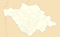
Santa Ana Nopalucan

Last updated
Santa Ana Nopalucan
Land of the Prickly Pear Cactus and Reed Bed Mats
Santa Ana Nopalucan
Fuente en atrio de la Parroquia de Santa Ana Nopalucan, Tlaxcala 01.jpg
Flag of Tlaxcala.svg
Mexico Tlaxcala location map.svg
Red pog.svg
Santa Ana Nopalucan
Mexico States blank map.svg
Red pog.svg
Santa Ana Nopalucan
Coordinates: 19°18′00″N98°20′00″W / 19.3°N 98.3333°W / 19.3; -98.3333
CountryFlag of Mexico.svg  Mexico
State Tlaxcala
Time zone UTC-6 (Central)

Santa Ana Nopalucan is a town and its surrounding municipality in the Mexican state of Tlaxcala. [1]

Contents

Other native names for Nopalucan

History

Pre-Hispanic

The history of the first settlers of what today is the municipality of Santa Ana Nopalucan goes back to the Olmec culture - Xicalanca, the region of Nopalucan was step by step forced towards the territory of Cacaxtla and Xochitécatl. In its region there was cultivated the cacaxtli, a plant that gave birth to the name of the ceremonial center that was built there.

This valley was of great importance when the old Tlaxcaltecas were besieged by the Aztecs and were forced to dispense with the use of salt on their food, which at that time was a marine condiment. It was replaced by "Tequezquite", which was a mineral salt that was collected in Nopalucan and El Carmen Tequexquitla. In these same locations were the main suppliers of the tule or reed mats that were used by the inhabitants to sleep. Similarly, the inhabitants of Nopalucan along with those of Saint Vincent Xiloxochitla, were the main suppliers and transporters of the materials, which were also used for sleep. The tule or junco or reed was extracted from the trenches or canals built to separate the waters of the "Lagunillas" (marshes) and was an important source of trade in the pre-Cortesian artisan markets of the time. It brought great benefits for the inhabitants of Nopalucan.

The colony

Santa Ana Nopalucan or Santa Anita, was previously what they used to call it, due to the fact that it possessed few inhabitants. There were clay regions which had formed vast areas of 'Lagunillas', which were used during the colonial period for the grazing of livestock, and also where salt was obtained in the gaps.

The process of secularization began in Tlaxcala in December 1640, when the then Bishop of Puebla, Juan de Palofox y Mendoza, came in person to this part of his diocese to implement the provisions of the Catholic hierarchy. With this measure, was annulled the concession that the Franciscans shall not allow the presence of other churches within the province of Tlaxcala. The Church of Nopalucan was secularised in 1640; however, it was not their convent until May 29 of 1770.

In the year 1623, there was a registration of the doctrines of the province of Tlaxcala. It was friar Blas de Escobar, guardian of the Convent of San Felipe, who carried out this register in which was reported that during the visit to Santa Ana Nopalucan, he met with 107 people and the place was about one league from the head of the doctrine. By 1779, the parish of San Felipe Ixtacuixtla was composed of peoples of La Santísima Trinidad (the Holy Trinity of) Tenanyecac, Santa Ana Nopalucan, Santa Inés Tecuezcoma, Santa Justina, who did not have communal lands.

Nineteenth Century

The reform.- The state of Puebla on its part requested the Congress to grant the annexation of Tlaxcala, because it did not have a sufficient elements to be considered as a sovereign state. Faced with this situation the Tlaxcaltecas protested and they arrested the annexationist desires of Puebla. Only to Tlaxcala did the Congress give the category of a sovereign state, but the territory, was subject to the federal powers and was governed by a political leader who was appointed by the President of the Republic. For this reason, Tlaxcala was divided into seven parties: Tlaxcala, Ixtacuixtla, Huamantla, Nativitas, Chiautempan, Tlaxco and Apizaco. Santa Ana Nopalucan was integrated into the party of Ixtacuixtla.

Related Research Articles

<span class="mw-page-title-main">Puebla (city)</span> Metropolis in Puebla, Mexico

Puebla de Zaragoza, formally Heroica Puebla de Zaragoza, formerly Puebla de los Ángeles during colonial times, or known simply as Puebla, is the seat of Puebla Municipality. It is the capital and largest city of the state of Puebla, and the fourth largest city in Mexico, after Mexico City, Monterrey, and Guadalajara. A viceregal era planned city, it is located in the southern part of Central Mexico on the main route between Mexico City and Mexico's main Atlantic port, Veracruz—about 100 km (62 mi) east southeast of Mexico City and about 220 km (140 mi) west of Veracruz.

<span class="mw-page-title-main">Tlaxcala (city)</span> City in Tlaxcala, Mexico

Tlaxcala, officially Tlaxcala de Xicohténcatl, is the capital city and of the Mexican state of Tlaxcala and seat of the municipality of the same name. The city did not exist during the pre-Hispanic period but was laid out by the Spanish as a center of evangelization and governance after the Spanish conquest of the Aztec Empire. The city was designated as a diocese but eventually lost that status to Puebla as its population declined. The city still has many of its old colonial structures, including the former Franciscan monastery, and newer civic structures like the Xicohtencatl Theatre.

<span class="mw-page-title-main">Puebla</span> State of Mexico

Puebla, officially Free and Sovereign State of Puebla, is one of the 32 states which comprise the Federal Entities of Mexico. It is divided into 217 municipalities and its capital is the city of Puebla.

<span class="mw-page-title-main">Tlaxcala</span> State of Mexico

Tlaxcala, officially the Free and Sovereign State of Tlaxcala, is one of the 32 federal entities that comprise the Federal Entities of Mexico. It is divided into 60 municipalities and the capital city and the largest city is Tlaxcala de Xicohténcatl.

Tlalnepantla is the name of a city and a municipality in the Mexican state of Morelos.

<span class="mw-page-title-main">Zipaquirá</span> Municipality and city in Cundinamarca, Colombia

Zipaquirá is a municipality and city of Colombia in the department of Cundinamarca. Its neighboring municipalities are Cogua and Nemocón to the north; Tocancipá to the east; Tabio, Cajicá and Sopó to the south; and Subachoque and Pacho to the west. Its seat of municipal government is 49 kilometers from the national capital Bogotá. It is part of the Greater Bogotá Metropolitan Area, and is the capital of the Sabana Centro province. It is also the headquarters of the diocese of the same name and that includes much of the Department of Cundinamarca, extending to the centre of Bogotá, the region of Rionegro, the Ubaté Valley, and the region of Guavio.

<span class="mw-page-title-main">Huamantla</span> Municipal seat in Tlaxcala, Mexico

Huamantla is a small city in the municipality of the same name in the eastern half of the Mexican state of Tlaxcala. The area has a long indigenous history, but the city itself was not founded until the early colonial period, in the 1530s. It is mostly agricultural but it is best known for its annual homage to an image of the Virgin Mary called Our Lady of Charity. This includes a month of festivities, the best known of which are the “night no one sleeps” when residents create six km of “carpets” on the streets made from colored sawdust, flowers and other materials. The other is the “Huamantlada” a running of the bulls similar to that in Pamplona.

<span class="mw-page-title-main">Chiles en nogada</span> Stuffed pepper dish with walnut cream sauce

Chiles en nogada is a Mexican dish of poblano chiles stuffed with picadillo topped with a walnut-based cream sauce called nogada, pomegranate seeds and parsley, and it is typically served at room temperature. It is widely considered a national dish of Mexico.

<span class="mw-page-title-main">Tlaltenango de Sánchez Román Municipality</span> Place in Zacatecas, Mexico

Tlaltenango de Sánchez Román is a municipality located in the southwestern portion of the Mexican state of Zacatecas. The average elevation of the municipality is 1,723 meters (5,653 ft) above sea level and the municipality covers an area of 808.082 square kilometres (312.002 sq mi). The municipality lies in a valley bordered by the Sierra de Morones and lies on the banks of the Tlaltenango River, which runs north and is a tributary of the Bolaños River.

Tlatlaya is one of 125 municipalities of the State of Mexico in Mexico. The municipal seat is the town of Tlatlaya which is the eleventh largest town in the municipality. The word “Tlatlaya” means when the hearth is black and red.

<span class="mw-page-title-main">La Manzanilla de La Paz</span> Municipality and town in Jalisco, Mexico

La Manzanilla de La Paz is a town and municipality, in Jalisco in central-western Mexico. The municipality covers an area of 134 km². As of 2020, the municipality had a total population of 4,099.

<span class="mw-page-title-main">Huejotzingo</span> City and municipality in Puebla, Mexico

Huejotzingo is a small city and municipality located just northwest of the city of Puebla, in central Mexico. The settlement's history dates back to the pre-Hispanic period, when it was a dominion, with its capital a short distance from where the modern settlement is today. Modern Huejotzingo is located where a Franciscan monastery was founded in 1525, and in 1529, the monks moved the indigenous population of Huejotzingo to live around the monastery. Today, Huejotzingo is known for the production of alcoholic apple cider and fruit preserves, as well as its annual carnival. This carnival is distinct as it centers on the re-enactment of several historical and legendary events related to the area. The largest of these is related to the Battle of Puebla, with about 2, 000 residents representing French and Mexican forces that engage in mock battles over four days.

<span class="mw-page-title-main">San Salvador Huixcolotla</span> Municipality and town in Puebla, Mexico

San Salvador Huixcolotla is a town and municipality in the Mexican state of Puebla in southeastern Mexico that may be best known as the birthplace of papel picado. San Salvador is of Spanish origin and translates to "Holy Savior" and Huixcolotla is Nahuatl for "place of the curved spines".

Desiderio Hernández Xochitiotzin was a Mexican artist best known for his large-scale mural work inside the State Government Palace in the state of Tlaxcala, Mexico, the last large scale mural of the Mexican muralism movement.

<span class="mw-page-title-main">Zacatelco</span> City in Tlaxcala, Mexico

Zacatelco is a city and municipal seat of Zacatelco municipality located in the south of the Mexican state of Tlaxcala. According to the 2010 population census conducted by the National Institute of Statistics and Geography, the city has a population of 38,466 people, it is the sixth most populous city in the state and is part of the Metropolitan area of Puebla. The city is also head of the third electoral district of Tlaxcala.

The following is a timeline of the history of the city of Puebla, Mexico.

Tequesquite or tequexquite is a natural mineral salt containing compounds of sodium chloride, sodium carbonate, and sodium sulphate, used in Mexico since pre-Hispanic times mainly as a food seasoning. It is found naturally in central Mexico particularly in previously lacustrine environments where the mineral salt forms a sedimentary crust.

<span class="mw-page-title-main">Handcrafts and folk art in Tlaxcala</span> Artistic traditions of Tlaxaca, Mexico

Tlaxcala handcrafts and folk art is that which comes from the smallest state in Mexico, located in the center-east of the country. Its best-known wares are the "canes of Apizaco", sawdust carpets and the making of Saltillo-style serapes. However, there are other handcraft traditions, such as the making of pottery, including Talavera type wares, cartoneria, metalworking and stone working. The state supports artisans through the activities of the Fideicomiso Fondo de la Casa de las Artesanía de Tlaxcala

<span class="mw-page-title-main">Convent Church of Nuestra Señora del Carmen, Puebla</span> Church in Mexico

The Conventual Temple of Our Lady of Carmen, currently known as the Church of the Virgin of Carmen, is a religious temple of Catholic worship that belongs to the ecclesiastical jurisdiction of the Archdiocese of Puebla de los Ángeles, under the invocation of the Virgen del Carmen. It is an example of the Baroque architecture of Puebla from the early seventeenth century, two of its chapels are of remarkable workmanship and decoration, as is the main nave that contains paintings such as the Santísima Trinidad de Cristóbal de Villalpando and its neoclassical altarpiece that houses the image of the Virgin, the work of the sculptor José Antonio Villegas Cora. The patronal feast is celebrated on July 16.

References

  1. "-". Enciclopedia de los Municipios de México. Instituto Nacional para el Federalismo y el Desarrollo Municipal . Retrieved January 4, 2009.