Santo Domingo (canton), Costa Rica

Last updated

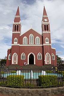
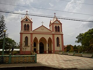
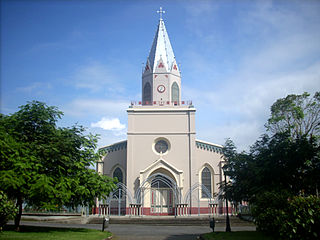
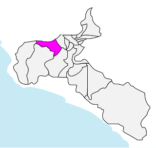
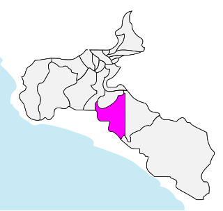
Santo Domingo is the third canton in the province of Heredia in Costa Rica. The canton covers an area of 24.84 km², [1] and has a population of 36,899. [2] The capital city of the canton is also called Santo Domingo.

Cantons of Costa Rica political subdivision of Costa Rica

Costa Rica is administratively divided into seven provinces which are subdivided into 82 cantons, and these are further subdivided into districts. Cantons are the only administrative division in Costa Rica that possess local government in the form of municipalities. Each municipality has its own mayor and several representatives, all of them chosen via municipal elections every four years.

Heredia Province Province in Costa Rica

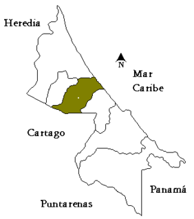
Heredia is a province of Costa Rica. It is in the north-central part of the country. As a result, the province covers areas as diverse as the agriculture-rich Northern plains to the more metropolitan areas such as the city of Heredia in the Central Valley. It contains several major environmentally important areas such as the Braulio Carrillo National Park and the Sarapiqui River. The capital is the city of Heredia.

Costa Rica country in Central America

Costa Rica, officially the Republic of Costa Rica, is a country in Central America, bordered by Nicaragua to the north, the Caribbean Sea to the northeast, Panama to the southeast, the Pacific Ocean to the southwest, and Ecuador to the south of Cocos Island. It has a population of around 5 million in a land area of 51,060 square kilometers. An estimated 333,980 people live in the capital and largest city, San José with around 2 million people in the surrounding metropolitan area.

The Río Virilla on the south and the Río Bermúdez on the north establish the boundaries of this elongated province, which then climb up into the Cordillera Central (Central Mountain Range) with the Río Pará Blanca.

Cordillera Central (Costa Rica) mountain range in Costa Rica

The Cordillera Central is a volcanic mountain range in central Costa Rica which continues from the Continental Divide to east of Cordillera de Tilarán. It extends 80 km from Tapezco Pass to the Turrialba Volcano and ending on the Pacuare River. It is separated from Cordillera de Tilarán by Balsa River and Platanar and Zarcero hills. The Cordillera Central is part of the American Cordillera, a chain of mountain ranges (cordillera) that consists of an almost continuous sequence of mountain ranges that form the western "backbone" of North America, Central America, South America and Antarctica.

The canton of Santo Domingo is subdivided into 8 distritos (districts).

  1. Santo Domingo
  2. San Vicente
  3. San Miguel
  4. Paracito
  5. Santo Tomás
  6. Santa Rosa
  7. Tures
  8. Pará

History

The canton was established by a government resolution of October 28, 1856.

Related Research Articles

San José (canton) Canton in San José, Costa Rica

San José is the first canton in the province of San José in Costa Rica. The canton covers an area of 44.62 km² and has a population of 288,054. It includes the national capital city of San José.

Desamparados (canton) canton of Costa Rica

Desamparados is the 3rd canton in the province of San José in Costa Rica. The canton covers an area of 118.26 km², and has a population of 206,708, making it the third most populated among the 81 cantons of Costa Rica. The capital city of the canton is also called Desamparados.

Puriscal (canton) canton of Costa Rica

Puriscal is the 4th canton in the province of San José, Costa Rica. In Spanish, a "puriscal" is the flower of the common bean. The capital city of the canton is Santiago (de Puriscal).

Grecia (canton) Cantón in Alajuela, Costa Rica

Grecia is the third canton in the province of Alajuela in Costa Rica. The canton covers an area of 395.72 square kilometres (152.79 sq mi), and has a population of 85,087. The capital city of the canton is also called Grecia.

Naranjo (canton) Cantón in Alajuela, Costa Rica

Naranjo is the sixth canton in the province of Alajuela in Costa Rica. The canton covers an area of 126.62 square kilometres (48.89 sq mi), and has a population of 45,005.

Poás (canton) Cantón in Alajuela, Costa Rica

Poás is the eighth canton in the province of Alajuela in Costa Rica. The canton covers an area of 73.84 square kilometres (28.51 sq mi), and has a population of 30,650.

San Mateo (canton) Cantón in Alajuela, Costa Rica

San Mateo is the fourth canton in the province of Alajuela in Costa Rica. The canton covers an area of 125.90 square kilometres (48.61 sq mi), and has a population of 7,600(estimate as of 2017).

San Isidro is the sixth canton in the province of Heredia in Costa Rica. The canton covers an area of 26.96 km², and has a population of 17,037. The capital city of the canton is also called San Isidro.

Flores is the eighth canton in the province of Heredia in Costa Rica. The canton covers an area of 6.96 km², and has a population of 16,036. The capital city of the canton is San Joaquín.

San Pablo is the ninth canton in the province of Heredia in Costa Rica. The canton covers an area of 7.53 km², and has a population of 22,038. The capital city of the canton is also called San Pablo.

Turrubares (canton) canton in Costa Rica

Turrubares is the 16th canton in the province of San José in Costa Rica. The canton covers an area of 415.29 square kilometres (160.34 sq mi), and has a population of 5,175, making it the least populated of the 81 cantons in Costa Rica. The capital city of the canton is San Pablo.

Moravia (canton) Canton in San José, Costa Rica

Moravia is the 14th canton in the province of San José in Costa Rica. The canton covers an area of 28.62 km², and had a total population of 56,919 people at the 2011 Census. The capital city of the canton is San Vicente.

Acosta (canton) Canton in San José, Costa Rica

Acosta is the 12th canton in the province of San José in Costa Rica. The canton covers an area of 242.24 km2 (93.53 sq mi), and has a population of 19,342. The capital city of the canton is San Ignacio.

Alajuelita (canton) canton of Costa Rica

Alajuelita is the 10th canton in the province of San José in Costa Rica. The canton covers an area of 21.17 km², and has a population of 75,418. The capital city of the canton is Alajuelita.

Goicoechea (canton)

Goicoechea is the eighth canton in the province of San José in Costa Rica. The canton covers an area of 31.5 km2 (12.2 sq mi), and has a population of 124,704. The capital city of the canton is Guadalupe.

Mora (canton) canton in the province of San José in Costa Rica

Mora is the 7th canton in the province of San José in Costa Rica. The canton covers an area of 162.04 km², and has a population of 23,004. The capital city of the canton is Ciudad Colón.

Aserrí (canton) canton of Costa Rica

Aserrí is the 6th canton in the province of San José in Costa Rica. The canton covers an area of 167.10 km², and has a population of 52,808. The capital city of the canton is also called Aserrí.

Tarrazú (canton) canton in San José, Costa Rica

Tarrazú is the 5th canton in the province of San José in Costa Rica. The canton covers an area of 297.50 km², and has a population of 17,233 The capital city of the canton is San Marcos.

Limón (canton) canton in Limón Province

Limón is the first canton in the province of Limón in Costa Rica. The canton covers an area of 1,765.79 km², and has a population of 97,102. Its capital is the provincial capital city of Puerto Limón.

Siquirres (canton) canton of Costa Rica

Siquirres is the third canton in the province of Limón in Costa Rica. The canton covers an area of 860.19 km², and has a population of 56,246. Its capital city is Siquirres.

References

  1. Instituto Geográfico Nacional (IGN), 2001.
  2. Estimates of Instituto Nacional de Estadística y Censos (INEC), May 2003.

Coordinates: 9°59′N84°05′W / 9.983°N 84.083°W / 9.983; -84.083

Geographic coordinate system Coordinate system

A geographic coordinate system is a coordinate system that enables every location on Earth to be specified by a set of numbers, letters or symbols. The coordinates are often chosen such that one of the numbers represents a vertical position and two or three of the numbers represent a horizontal position; alternatively, a geographic position may be expressed in a combined three-dimensional Cartesian vector. A common choice of coordinates is latitude, longitude and elevation. To specify a location on a plane requires a map projection.