Sapperton Valley

Last updated

Sapperton Valley
Towpath, Thames and Severn canal, near Frampton Mansell - geograph.org.uk - 1133865.jpg
Walkers in the reserve by the old canal
Gloucestershire UK location map.svg
Red pog.svg
Sapperton Valley shown within Gloucestershire
Sapperton Valley
TypeGloucestershire Wildlife Trust nature reserve
LocationFrome Valley near Sapperton and east of Chalford
Coordinates 51°43′50.26″N2°5′41.25″W / 51.7306278°N 2.0947917°W / 51.7306278; -2.0947917 Coordinates: 51°43′50.26″N2°5′41.25″W / 51.7306278°N 2.0947917°W / 51.7306278; -2.0947917
Area9.2 acres (3.7 ha)
Created1964
Operated byGloucestershire Wildlife Trust Bathurst Estate
StatusOpen all year

Sapperton Valley (grid reference SO935035 ) is a 3.7-hectare (9.1-acre) nature reserve near Chalford in the Stroud district of Gloucestershire, England. The site is managed by the Gloucestershire Wildlife Trust under leasing arrangements with the Bathurst Estate, in place since 1964. [1] [2]

Contents

Location and habitat

The reserve is close to Sapperton and Frampton Mansell, and about two miles east of Chalford. It lies south of two other nature reserves: Siccaridge Wood and Daneway Banks, the latter a Site of Special Scientific Interest. The Sapperton Valley reserve is a long ribbon of canal bank, water meadows and woodland by the disused former Thames and Severn Canal. The River Frome runs parallel to the old canal and is the boundary to the reserve on its south side. The reserve is about a mile long. [1]

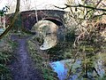
The canal was built originally to link the Stroud mills which supported the woollen trade, and was opened in the late 18th century. The length from Whitehall Bridge to Lechlade closed in the early 20th century. A road bridge is the western end of the nature reserve; access to the reserve is along the towpath. There is some space for vehicles south of Daneway Bridge. [1] The canal construction included a long tunnel, deep locks, bridges, a loading basin and the Daneway Inn, built to accommodate the men working on the tunnel. [3]

The Sapperton Valley is considered to be an important wetland area, situated as it is between the Frome and the canal. There are a series of wet meadows and this area is damp, generally undisturbed and overgrown, supporting wildlife. A diversity of habitats are thus concentrated in a relatively small area and range from ancient woodland to wetland. [3] The 2005 Stroud District Local Plan identified the valley as a Key Wildlife Site. [4]

Woodland and plant life

The trees along the canal include pedunculate oak, ash, crack willow and field maple. The area is colonised with common reed, reed sweet-grass and the more open areas support marsh-marigold, yellow water-lily, water dock and gipsywort. [1] Meadowsweet and great willowherb flourish. There is also common valerian, purple-loosestrife, common marsh-bedstraw, yellow iris, ragged robin and marsh woundwort. Woodland flowers such as primrose, bluebell, yellow archangel and bugle thrive in a small wood near the tunnel entrance and under the towpath hedgerows. [1] [3] This wetland area supports a variety of fungi, liverworts and mosses. [1]

Bird life

This is a reserve rich in bird life and recorded are moorhen, mallard, nuthatch, grey wagtail, marsh tit and blackcap. Mallard, moorhen and grey wagtail breed in the reserve. Herons and kingfishers are seen in the area. [1]

Other species

There are good populations recorded of the common frog and common toad. Bats feed and roost in the area. Fallow deer are visitors to the reserve as is the fox. Molluscs found include the uncommon land winkle and Rolph's door snail. [1] Dragonflies forage in the area and the reserve supports good populations of butterflies and moths. [3]

Conservation

The meadow areas are cut at the end of the summer to control the more dominant species. This practice supports the increase in the range of flowers. [1]

Walks

There is a publication which details walks for recreation and observing wildlife in the Golden Valley. This includes information on Sapperton Valley and four other nearby nature reserves being Strawberry Banks SSSI, Three Groves Wood, Daneway Banks SSSI and Siccaridge Wood. The walk also includes other ancient woodland at Peyton's Grove, Oakridge village, Bakers Mill and Reservoir, Ashmeads Spring, and part of the route of the old Thames and Severn Canal. [5]

Publications

Related Research Articles

Gloucestershire Wildlife Trust Organization

The Gloucestershire Wildlife Trust is the Gloucestershire local partner in a conservation network of 46 Wildlife Trusts. The Wildlife Trusts are local charities with the specific aim of protecting the United Kingdom's natural heritage. The Gloucestershire Wildlife Trust is managed by a Board of Trustees elected from its membership who provide overall direction for the development of the Trust and there are Advisory Committees. The work of the trust is carried out through staff and volunteers.

Lower Woods

Lower Woods is a 280.1-hectare (692-acre) biological and geological Site of Special Scientific Interest near the village of Wickwar, South Gloucestershire, notified in 1966 and renotified in 1985. The site area has increased at last revision in 1974 to a 284.1-hectare (702-acre) site. The site is a nature reserve managed by the Gloucestershire Wildlife Trust.

Midger

Midger is a 65.7-hectare (162-acre) biological Site of Special Scientific Interest straddling the border of Gloucestershire and South Gloucestershire, notified in 1966 and renotified in 1984. Since the last revision in 1974, the size has been reduced to a 56-hectare (140-acre) site. It lies east of Hillesley, Gloucestershire and north of Hawkesbury Upton, South Gloucestershire. It is at the head of the Kilcott Valley.

Strawberry Banks Biological Site of Special Scientific Interest in Gloucestershire, England

Strawberry Banks is a 5.06-hectare (12.5-acre) biological Site of Special Scientific Interest in Gloucestershire, notified in 1993.

Cannop Ponds

Cannop Ponds are two large ponds, just north of Parkend in the Forest of Dean, Gloucestershire, England. The ponds, and surrounding area, are a popular tourist destination.

Daneway Banks SSSI Biological Site of Special Scientific Interest in Gloucestershire, England

Daneway Banks is a 17-hectare (42-acre) biological Site of Special Scientific Interest in Gloucestershire, notified in 1954 and renotified in 1983. It lies half a mile west of Sapperton and is part of a group of wildlife sites in the Frome Valley that includes Siccaridge Wood and Sapperton Canal reserves. The site is in the Cotswold Area of Outstanding Natural Beauty.

Dymock Woods SSSI Biological Site of Special Scientific Interest in Gloucestershire, England

Dymock Woods is a 53-hectare (130-acre) biological Site of Special Scientific Interest in Gloucestershire, notified in 1990. The site is listed in the 'Forest of Dean Local Plan Review' as a Key Wildlife Site (KWS).

Hobbs Quarry SSSI, Longhope

Hobbs Quarry, Longhope is a 1-hectare (2.5-acre) geological and biological Site of Special Scientific Interest in Gloucestershire, England, notified in 1966. It is situated midway between Longhope and Dursley Cross in the Forest of Dean. Adjacent woods are Kiln Wood and Coleman's Wood. The site is managed by the Gloucestershire Wildlife Trust.

Collinpark Wood SSSI Biological Site of Special Scientific Interest in Gloucestershire, England

Collinpark Wood is a 66.69-hectare (164.8-acre) biological Site of Special Scientific Interest in Gloucestershire, notified in 1966, revised in 1974 and renotified in 1983. There was a boundary change in 1983. There are seven units of assessment. Unit 1 is a 15-hectare (37-acre) area owned and managed by the Gloucestershire Wildlife Trust. The trust purchased this part of the wood in 1979 with grant aid from WWF. The site is listed in the 'Forest of Dean Local Plan Review' as a Key Wildlife Site (KWS).

Bull Cross, The Frith and Juniper Hill Site of Special Scientific Interest in Gloucestershire, England

Bull Cross, The Frith and Juniper Hill is a 42.33-hectare (104.6-acre) biological and geological Site of Special Scientific Interest in Gloucestershire, notified in 1954. The site is listed in the ‘Stroud District’ Local Plan, adopted November 2005, Appendix 6 as an SSSI and Regionally Important Geological Site (RIGS).

Woorgreens Lake and Marsh

Woorgreens Lake and Marsh is a 9-hectare (22-acre) nature reserve in Gloucestershire.

Foxes Bridge Bog

Foxes Bridge Bog is a 5.3-hectare (13-acre) nature reserve in Gloucestershire. The site is owned by the Forestry Commission and is managed by the Gloucestershire Wildlife Trust in partnership with the Forestry Commission. The site is listed in the 'Forest of Dean Local Plan Review' as a Key Wildlife Site (KWS).

Ridley Bottom, Tidenham Nature reserve in Gloucestershire, England

Ridley Bottom is a 1.1-hectare (2.7-acre) nature reserve in Gloucestershire. The site is listed in the 'Forest of Dean Local Plan Review' as a Key Wildlife Site (KWS).

Vell Mill Daffodil Meadow Nature reserve in Gloucestershire, England

Vell Mill Daffodil Meadow is a 2.1-hectare (5.2-acre) nature reserve in Gloucestershire.

Gwen and Veras Fields Nature reserve in Gloucestershire, England

Gwen and Vera's Fields is a 0.28-hectare (0.69-acre) nature reserve in Gloucestershire.

Chedworth Nature Reserve

Chedworth Nature Reserve is a 6-hectare (15-acre) nature reserve in Gloucestershire. The site is listed in the 'Cotswold District' Local Plan 2001-2011 as a Key Wildlife Site (KWS).

Frome Banks

Frome Banks is a 1.3-hectare (3.2-acre) nature reserve in Gloucestershire.

Snows Farm Nature Reserve

Snows Farm Nature Reserve is a 21.3-hectare (53-acre) nature reserve in Gloucestershire. The site is listed in the ‘Stroud District’ Local Plan, adopted November 2005, Appendix 6 as a Key Wildlife Site (KWS).

Three Groves Wood Nature reserve in Gloucestershire, England

Three Groves Wood is a 3.3-hectare (8.2-acre) nature reserve in Gloucestershire. The site is listed in the ‘Stroud District’ Local Plan, adopted November 2005, Appendix 6 as a Key Wildlife Site (KWS).

Siccaridge Wood

Siccaridge Wood is a 26.6-hectare (66-acre) nature reserve in Gloucestershire. The site is listed in the ‘Stroud District’ Local Plan, adopted November 2005, Appendix 6 as a Key Wildlife Site (KWS).

References

  1. 1 2 3 4 5 6 7 8 9 Kelham, A, Sanderson, J, Doe, J, Edgeley-Smith, M, et al., 1979, 1990, 2002 editions, 'Nature Reserves of the Gloucestershire Trust for Nature Conservation/Gloucestershire Wildlife Trust'
  2. "Sapperton Valley". Gloucestershire Wildlife Trust. Retrieved 5 September 2017.
  3. 1 2 3 4 ‘Nature Reserve Guide – discover the wild Gloucestershire on your doorstep’ – 50th Anniversary, January 2011, Gloucestershire Wildlife Trust
  4. "Stroud District Local Plan" (PDF). Stroud District Council. November 2005. p. 169. Archived from the original (PDF) on 15 February 2015.
  5. 'The Golden Valley Walk', (undated), Gloucestershire Wildlife Trust