Sargent station

Last updated

Sargent
Sargents Station.jpg
Sargent Station
General information
Location Monterey Road
Santa Clara County, California, U.S.
Coordinates 36°55′10″N121°32′53″W / 36.91944°N 121.54806°W / 36.91944; -121.54806
Line(s) Coast Line
Platforms1 side platform
Tracks1
History
Opened1869
Services
Preceding station Southern Pacific Railroad Following station
Gilroy Coast Line Aromas
toward Los Angeles

Sargent station was a railroad depot for Sargent, California. The station stop was established in 1869 when the Santa Clara and Pajaro Valley Railroad extended its line to Sargent. Located near the mouth of Pescadero Creek and adjacent to the Sargent Ranch, the station was named after James Pattee Sargent, who owned the Rancho Juristac Mexican land grant and served in the California State Assembly representing Santa Clara County.

Contents

History

Prior to 1769, the site was inhabited by approximately 2,700 Amah Mutsun Ohlone Indigenous peoples who lived in villages along the Pajaro River before the arrival of Spanish colonizers who settled in Alta California. Today[ when? ] most of the over 500 members of the Amah Mutsun band are descendants of the native people who were later baptized at Mission San Juan Bautista. [1] Spanish explorers led by the military officer Juan Bautista de Anza and Pedro Font (missionary) first passed through the Santa Clara Valley area in 1776. Later, in 1797 Mission San Juan Bautista was established near the Pajaro River. [2] In 1835, Antonio and Faustino German were granted, by Governor José Castro, the 4,540-acre (18.4 km2) Mexican land grant Rancho Juristac. [3]

In 1856 James Pattee Sargent (1823–1890), a rancher and assemblyman, bought Rancho Juristac with his brothers, where he established his residence, later known as Sargent Ranch." [1]

Passenger service

Southern Pacific RR Coast Line Time Tables for December 1945. Southern Pacific RR Coast Line Time Tables December 1945.jpg
Southern Pacific RR Coast Line Time Tables for December 1945.
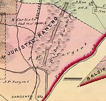
Sargent station can be seen along Southern Pacific Railroad and Monterey Road on the 1876 Thompson & West Map of Santa Clara County. Rancho Juristac Map.jpg
Sargent station can be seen along Southern Pacific Railroad and Monterey Road on the 1876 Thompson & West Map of Santa Clara County.

The Sargent station opened in 1869 under the Santa Clara and Pajaro Valley Railroad making Sargent Station a railway stop near Sargent Ranch, owned by rancher and former assemblyman James Pattee Sargent. A year later, the line was acquired by Southern Pacific Railroad. [4] [5]

By 1872, southern destinations could be reached daily by taking the Southern Pacific railroad to Gilroy, continuing to Sargent's Station, and then proceeding by stagecoach. [6] By 1890, the Monterey Express stopped at Sargent Station to allow passengers to continue by stage to San Juan and Hollister. [7]

There were several train crashes at Sargent Station. For instance, on November 12, 1906, the engine boiler of the Sunset Limited train No. 10 exploded at Sargent's Station, setting the station building on fire. [8] In 1897, Del Monte Express struck a bowlder, causing damage and derailing one of its cars. [9] By 1945, Southern Pacific Railroad Coast Line timetables indicated that stops at Sargent station were made on signal for passengers traveling to Los Angeles and other destinations. [10]

Freight stop

The beet-loading tower sitting beside the abandoned spur at Sargent station in 2024. Beet-loading tower sitting beside the abandoned spur at Sargent.jpg
The beet-loading tower sitting beside the abandoned spur at Sargent station in 2024.

Sargent Station was a key site for shipping oil along Monterey Road to San Jose. Around the turn of the century, the Watsonville Oil Company began extracting oil from the Sargent Ranch oil field. By 1864, an oil and kerosene distillery was operating at Sargent Station. When the company ceased operations in 1948, it had shipped 780,000 barrels of oil from the station. [1] [11]

In 1949, the Union Sugar Company established a beet loading station in Sargent. To accommodate this, Southern Pacific constructed a new spur track to serve the loading station. Beets were transferred from trucks into the train cars. The sugar beet loader has been abandoned but can be seen along Highway 101 near the town of Sargent. [12]

Related Research Articles

<span class="mw-page-title-main">Castroville, California</span> Unincorporated community in California, United States

Castroville is an unincorporated town and census-designated place (CDP) in Monterey County, California, United States. At the time of the 2020 census the population was 7,515, up from 6,481 in 2010. Castroville is known for its artichoke crop and for the annual Castroville Artichoke Festival, leading to its nickname as the "Artichoke Center of the World".

<span class="mw-page-title-main">Gilroy, California</span> City in California, United States

Gilroy is a city in Santa Clara County, California, United States. Gilroy is the southernmost city in the San Francisco Bay Area, with a population of 59,520 as of the 2020 Census.

<span class="mw-page-title-main">Santa Cruz Mountains</span> Mountain range in California, United States

The Santa Cruz Mountains are a mountain range in central and Northern California, United States, constituting a part of the Pacific Coast Ranges. They form a ridge down the San Francisco Peninsula, south of San Francisco. They separate the Pacific Ocean from the San Francisco Bay and the Santa Clara Valley, and continue south to the Central Coast, bordering Monterey Bay and ending at the Salinas Valley. The range passes through the counties of San Mateo, Santa Clara, and Santa Cruz, with the Pajaro River forming the southern boundary.
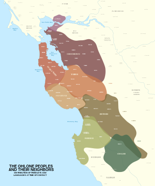
<span class="mw-page-title-main">Ohlone</span> Native American people of the Northern California coast

The Ohlone, formerly known as Costanoans, are a Native American people of the Northern California coast. When Spanish explorers and missionaries arrived in the late 18th century, the Ohlone inhabited the area along the coast from San Francisco Bay through Monterey Bay to the lower Salinas Valley. At that time they spoke a variety of related languages. The Ohlone languages make up a sub-family of the Utian language family. Older proposals place Utian within the Penutian language phylum, while newer proposals group it as Yok-Utian.

Rancho Santa Margarita was a 17,735-acre (71.77 km2) Mexican land grant in the Santa Lucia Mountains, in present day San Luis Obispo County, central California.

<span class="mw-page-title-main">Claus Spreckels</span> Biography of sugar maven

Adolph Claus J. Spreckels was a major industrialist in Hawai'i during the kingdom, republican, and territorial periods of the islands' history. He also involved himself in several California enterprises, most notably the company that bears his name, Spreckels Sugar Company.
<span class="mw-page-title-main">Gabilan Range</span> Mountain range in the American state of California

The Gabilan Range or Gabilán Range are a mountain range in the inner California Coast Ranges System, located in Monterey County and San Benito County of central California. Pinnacles National Park is located in the southern section of the range.

<span class="mw-page-title-main">Mutsun language</span> Extinct Utian language

Mutsun is a Utian language spoken in Northern California. It was the primary language of a division of the Ohlone people living in the Mission San Juan Bautista area. The Tamien Nation and Amah Mutsun band is currently working to restore the use of the language, using a modern alphabet.

<span class="mw-page-title-main">Mission Indians</span> Indigenous peoples who were forcibly relocated to missions in Southern California

Mission Indians are the indigenous peoples of California who lived in Southern California and were forcibly relocated from their traditional dwellings, villages, and homelands to live and work at 15 Franciscan missions in Southern California and the Asistencias and Estancias established between 1796 and 1823 in the Las Californias Province of the Viceroyalty of New Spain.

<span class="mw-page-title-main">Awaswas</span> One of the Ohlone Native Americans of Northern California

The Awaswas, also known as the Santa Cruz people, were a group of the Indigenous peoples of California in North America, with subgroups historically numbering about 600 to 1,400. Academic research suggests that their ancestors had lived within the Santa Cruz Mountains region for approximately 12,000 years. The Awaswas maintained regular trade networks with regional cultures before the Spanish colonists began settling in the area from the 18th century.

<span class="mw-page-title-main">Gilroy station</span> Train station in Gilroy, California, U.S.

Gilroy station is a Caltrain station located in Gilroy, California, United States. It is the southernmost terminus of the Caltrain system, and is only served during weekday rush hours in the peak direction, with trains going toward San Francisco in the morning and returning southbound in the evening. The station building was constructed by the Southern Pacific Railroad in 1918 and restored in 1998. Future plans call for extended Amtrak Capitol Corridor service, as well as California High-Speed Rail trains, to also stop at Gilroy. The station was named to the National Register of Historic Places in 2019 as Gilroy Southern Pacific Railroad Depot.

<span class="mw-page-title-main">Rancho San Luis Gonzaga</span> Land grant in California

Rancho San Luis Gonzaga was a 48,821-acre (197.57 km2) Mexican land grant in the Diablo Range, in present-day Santa Clara County and Merced County, California given in 1843 by Governor Manuel Micheltorena to Juan Carlos Pacheco and José Maria Mejía. The grant was bounded by Francisco Pérez Pachecos Rancho Ausaymas y San Felipe on the west, the San Joaquin River and San Joaquin Valley on the east, and Los Baños Creek on the south.

<span class="mw-page-title-main">Communications Hill, San Jose</span> Neighborhood of San Jose in Santa Clara, California, United States

Communications Hill is a neighborhood located in the San Juan Bautista Hills of San Jose, California.

<span class="mw-page-title-main">Tar Creek (Santa Clara County)</span> River in California, United States

Tar Creek is an 8-mile-long (13 km) mainly southeastward-flowing stream originating on the eastern slopes of the Santa Cruz Mountains, in southern Santa Clara County, California, United States. Tar Creek flows through the Sargent Ranch, once the Rancho Juristac Mexican Land grant. It crosses under U.S. Highway 101 and about 5 miles (8.0 km) south of Gilroy, California joins lower Uvas Creek. From the Tar Creek confluence, lower Uvas Creek flows shortly south to its confluence with the Pajaro River at the Santa Clara County - San Benito County boundary.
<span class="mw-page-title-main">Monterey County Rail Extension</span>

The Monterey County Rail Extension is a planned commuter rail extension that would bring Caltrain passenger service south of its existing Gilroy, California terminus to Salinas in Monterey County, using the existing Coast Line owned by Union Pacific (UPRR). Implementation of the rail extension will occur over three phases, starting from Salinas and moving north. When construction is complete, there will be four trains operated over the extended line per weekday: two northbound trains that depart from Salinas and travel to San Francisco in the morning, and two southbound trains that return to Salinas in the afternoon.

<span class="mw-page-title-main">Bradley Varnum Sargent</span> American pioneer and politician

Bradley Varnum Sargent, also known as B. V. Sargent, was an American pioneer who served as a member of the California State Senate, representing Monterey County from 1887 to 1889. He also owned large ranch holdings in Monterey County.

<span class="mw-page-title-main">James Pattee Sargent</span> California pioneer and politician

James Pattee Sargent, also known as J. P. Sargent, was an American pioneer who served as a member of the California State Assembly, representing Santa Clara County, California from 1871 to 1873. He owned Rancho Juristac in Santa Clara County and was one of the wealthiest landowners in the county. Sargent Station, situated between Watsonville and Gilroy on the Southern Pacific Railroad, was named after him.

<span class="mw-page-title-main">Sargent, California</span> City in California, United States

Sargent is a ghost town in central California, located on the border of San Benito County, California. Most of the town lies on the north side of the county line in Santa Clara County, approximately 5 miles (8 km) south of Gilroy, along the Southern Pacific Railroad track, just west of U.S. 101. The town is located at an elevation of 144 feet above sea level. Founded in 1864 as a farming town, Sargent emerged during the booming railroad era, which enabled towns to develop along the tracks.

<span class="mw-page-title-main">Coyote station</span> Rail station in California, US, 1869–1959

Coyote station was a railroad depot in Coyote, California, United States. Established in 1869, the station was part of the Southern Pacific Railroad's first line connecting San José and Gilroy. Located in the heart of the Coyote Valley, the depot took its name from the Coyote Creek and explorer Juan Bautista de Anza who referred to the area as "Arroyo del Coyote." The train station was in use until the cancellation of the train route in 1959. Recently, in May 2024, Coyote station was relocated to History Park at Kelley Park in San José. The building will be restored and made into a transportation museum.

References

  1. 1 2 3 Hart, Richard E. (2019). "Federal Recognition Of Native American Tribes: The Case Of California's Amah Mustsun" (PDF). www.protectjuristac.org. pp. 66–67. Retrieved May 21, 2024.
  2. "Local Landscape Descriptions" (PDF). San Francisco Estuary Institute. pp. 199–200. Retrieved May 16, 2024.
  3. Hoffman, Ogden (1862). Reports of Land Cases Determined in the United States District Court for the Northern District of California. San Francisco: Numa Hubert. Retrieved May 31, 2024.
  4. Hart, Richard E. (2019). "Federal Recognition Of Native American Tribes: The Case Of California's Amah Mustsun" (PDF). www.protectjuristac.org. pp. 66–67. Retrieved May 21, 2024.
  5. Pierce, Marjorie (1981). East of the Gabilans The Ranches, the Towns, the People--yesterday and Today. Western Tanager Press. pp. 150–152. ISBN   978-0-934136-11-2 . Retrieved May 16, 2024.
  6. "Paso Robles Hot Sulphur Springs". The San Francisco Examiner. San Francisco, California. March 9, 1872. p. 2. Retrieved May 22, 2024.
  7. "Salinas Daily Journal". The Californian. Salinas, California. March 30, 1890. Retrieved May 29, 2024.
  8. "Uncle Collis' Carless Men. Very Serious Train Wreck at Sargents Station is Narrowly Avertd". The San Francisco Examiner. San Francisco, California. September 6, 1897. p. 4. Retrieved May 29, 2024.
  9. "Wrecked On Rails. Engine Boilder Explodes at Sargent's Station and Wrecks Depot". The Los Angeles Times. Los Angeles, California. November 12, 1906. Retrieved May 29, 2024.
  10. "Southern Pacific RR Coast Line Time Tables". December 1945. Retrieved May 30, 2024.
  11. David L. Wagner; Bill Fedasko; J.R. Carnahan; Ross Brunetti; Leslie B. Magoon; Paul G. Lillis (2002). "Tar Creek study, Sargent oil field, Santa Clara County, California". Sacramento, California: California Department of Conservation, Division of Oil, Gas, and Geothermal Resources. p. 17.
  12. "Union Sugar Adds New Beet Lading Station". The Californian. Salinas, California. May 21, 1949. p. 20. Retrieved May 24, 2024.