| Sass da Ciampac | |
|---|---|
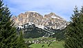
 Southeast aspect | |
| Highest point | |
| Elevation | 2,672 m (8,766 ft) [1] |
| Prominence | 304 m (997 ft) [1] |
| Parent peak | Furchëta [1] |
| Isolation | 3.38 km (2.10 mi) [1] |
| Coordinates | 46°33′47″N11°50′07″E / 46.563121°N 11.835304°E [1] |
| Geography | |
 Sass da Ciampac Location in Italy | |
| Country | Italy |
| Province | South Tyrol |
| Protected area | Puez-Geisler Nature Park |
| Parent range | Dolomites Puez Group |
| Topo map | Tabacco Map 05 Val Gardena / Alpe di Siusi |
| Geology | |
| Rock age | Triassic |
| Rock type | Dolomite |
| Climbing | |
| First ascent | 1903 |
| Easiest route | Trail [1] |
Sass da Ciampac is a mountain in the province of South Tyrol in northern Italy.