Related Research Articles

La Porte is a census-designated place (CDP) in Plumas County, California, United States. The population was 65 at the 2020 census. The town was first known as Rabbit Creek until 1857.

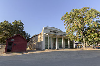
Chinese Camp is a census-designated place (CDP) in Tuolumne County, California, United States. The population was 126 at the 2010 census, down from 146 at the 2000 census. It lies in the grassy foothills of the Sierra Nevada near the southern end of California's Gold Country.

Tuolumne City is an unincorporated town in Tuolumne County, California. A census-designated place (CDP) officially known as Tuolumne also encompasses the town. The population of the CDP was 1,779 at the 2010 census, down from 1,865 at the 2000 census.

The Gold Country is a historic region in the northern portion of the U.S. state of California, that is primarily on the western slope of the Sierra Nevada. It is famed for the mineral deposits and gold mines that attracted waves of immigrants, known as the 49ers, during the 1849 California Gold Rush.

Dog Town is a gold rush era ghost town in Mono County, California. It is located at 38°10′13″N119°11′51″W, on Dog Creek, near the junction of Clearwater and Virginia Creeks, about 6 miles (10 km) south-southeast of Bridgeport, at an elevation of 7057 feet.

Douglas Flat is an unincorporated community in Calaveras County, California. It lies at an elevation of 1965 feet and is located at 38°06′52″N120°27′18″W. The community is in ZIP code 95229 and area code 209.
Carson Hill is a ghost town in Calaveras County, California. It sits at an elevation of 1447 feet above sea level and is located at 38°01′42″N120°30′24″W, about 4 miles (6.4 km) south-southeast of Angels Camp. It was one of the most productive mining camps in the state, with nearly $26 million in gold and quartz found in the area. Carson Hill is registered as California Historical Landmark #274. The town was served by the Sierra Railway's branchline to Angels Camp until 1935.
Altaville is a former unincorporated community in Calaveras County, California, now located in the northwest portion of the city of Angels Camp. It sits at an elevation of 1,542 feet above sea level and is located at 38°05′02″N120°33′43″W, at the intersections of SR 49 and SR 4. The community is in ZIP code 95221 and area code 209.

Marshall Gold Discovery State Historic Park is a state park of California, United States, marking the discovery of gold by James W. Marshall at Sutter's Mill in 1848, sparking the California Gold Rush. The park grounds include much of the historic town of Coloma, California, which is now considered a ghost town as well as a National Historic Landmark District. The park contains the California Historical Landmarks: a monument to commemorate James Marshall (#143), the actual spot where he first discovered gold in 1848 (#530). Established in 1942, and Coloma Road (#748),. The park now comprises 576 acres (233 ha) in El Dorado County.
La Grange is a small unincorporated community in rural Stanislaus County, California. Its altitude is 249 feet (76 m). As of 2020 it has a population of 166. It is located at 37°39′49″N120°27′49″W along the Tuolumne River, and is near the La Grange Dam and the New Don Pedro Dam.
Condemned Bar is a former settlement, in El Dorado County, California. It is in the Sierra Nevada foothills. The former town is now under Folsom Lake. A Historical Landmark marker was built at Folsom Lake State Recreation Area. The former mining town of the California Gold Rush is registered as California Historical Landmark #572.
Blue Mountain City is a former settlement in Calaveras County, California, along Licking Fork, approximately 20 miles (32 km) northeast of Mountain Ranch. The town was built on a flat bench of land above the mining camp which perched on a steep canyon slope on the west side of Licking Fork, just over a mile downstream from the headwaters. The town was first announced in January, 1863. The Heckendorn Gold and Silver Mining Company was organized by July, with C. C. Bowman as its secretary. A post office operated in Blue Mountain from 1863 to 1864.
Caldor was a company town in El Dorado County, California. Caldor was linked to Diamond Springs by the Diamond and Caldor Railway. The community was named for the California Door Company, which owned and operated the town.
Poverty Bar is a former settlement in Calaveras County, California, active from c. 1850s to 1862, and now covered by the waters of Camanche Reservoir. The nearest major town is Campo Seco, California.
Middle Bar is a former mining town on the Mokelumne River in Amador County, California. It is a California Historical Landmark.
French Flat or French Camp now a ghost town was in Tuolumne County, California. It was located near French Flat from which it took its name, one and a half miles south southwest of Tuttletown. Its location was near the flat, northwest of an 1,894-foot (577 m) mountain.
Martinez was a mining settlement during the California Gold Rush in Tuolumne County, California. It became a ghost town, but now is a populated place at an elevation of 2,182 feet, north of Sawmill Flat another former gold rush settlement.
Second Garrotte is a ghost town located near Groveland in Tuolumne County, California originally settled during the California Gold Rush. The site of Second Garrote is a California Historical Landmark, No. 460 listed on May 9, 1950. It lies at an elevation of 2,894 feet in Second Garrotte Basin.

Jacksonville, California is a historical farming town site in Chinese Camp, California in Tuolumne County, California. The site of the Jacksonville, California is a California Historical Landmark No. 419 listed on February 28, 1949. The town is now under the Don Pedro Reservoir formed in 1924. Jacksonville was founded by farmer Julian Smart along the Tuolumne River at an elevation of 800 feet. In spring 1849, Smart planted a garden and an orchard. Smart named the town Jacksonville after Colonel A. M. Jackson. The Tuolumne River provided water not only for the farms but the many 49 California Gold Rush mining operations in the region. In 1852 a US post office opened with a population of 252. The largest mine in the region was the Eagle-Shawmut mine.
Shaw's Flat, California is a historical ghost town and mining town in Columbia, California in Tuolumne County, California. The site of the Shaw's Flat is a California Historical Landmark No. 395 listed on March 8, 1948. Shaw's Flat was 49 California Gold Rush town founded in 1850. The town is named after it first settler, Mandeville Shaw. In November 1849, Shaw started an orchard on the eastern slope of Table Mountain. The California Gold Rush started shortly after Shaw's. Nearby Tarleton Caldwell, started Caldwell's Gardens by growing black walnut. Caldwell found gold on his land. James G. Fair found Gold and went on to be a United States senator.
References
Municipalities and communities of Tuolumne County, California, United States | ||
|---|---|---|
| City |  | |
| CDPs | ||
| Unincorporated communities | ||
| Ghost towns | ||
38°01′14″N120°22′51″W / 38.02056°N 120.38083°W
| | This Tuolumne County, California-related article is a stub. You can help Wikipedia by expanding it. |