U.S. Route 66 or U.S. Highway 66, also known as the Will Rogers Highway, the Main Street of America or the Mother Road, was one of the original highways in the U.S. Highway System. US 66 was established on November 11, 1926, with road signs erected the following year. The highway, which became one of the most famous roads in the United States, originally ran from Chicago, Illinois, through Missouri, Kansas, Oklahoma, Texas, New Mexico, and Arizona before terminating in Santa Monica in Los Angeles County, California, covering a total of 2,448 miles (3,940 km). It was recognized in popular culture by both the hit song "(Get Your Kicks on) Route 66" and the Route 66 television series, which aired on CBS from 1960 to 1964. In John Steinbeck's classic American novel, The Grapes of Wrath (1939), the road "Highway 66" symbolized escape and loss.

Sayre is a small city in, and the county seat of, Beckham County, in western Oklahoma, United States. It is halfway between Oklahoma City, and Amarillo, Texas, on Interstate 40 and the former U.S. Route 66. The population was 4,375 at the 2010 census, the largest recorded by a census since Sayre's founding. The total was an increase of 6.3 percent from the 2000 census.

Glenrio, formerly Rock Island, is an unincorporated community in both Deaf Smith County, Texas, and Quay County, New Mexico, United States. Located on the former U.S. Route 66, the ghost town sits on the Texas–New Mexico state line. It includes the Glenrio Historic District, which was listed on the National Register of Historic Places in 2007.
U.S. Route 66, the historic east–west US highway between Chicago, Illinois and Santa Monica, California, passed through one brief segment in the southeastern corner of Kansas. It entered the state south of Baxter Springs and continued north until it crossed the Brush Creek, from where it turned east and left the state in Galena. After the decertification of the highway in 1985, this road segment was numbered as US-69 (alternate) from Quapaw, Oklahoma north to Riverton, Kansas and as K-66 from Riverton east to Route 66 in Missouri.
The historic U.S. Route 66, also known as the Will Rogers Highway after Oklahoma native Will Rogers, ran from west to northeast across the state of Oklahoma, along the path now taken by Interstate 40 (I-40) and State Highway 66 (SH-66). It passed through Oklahoma City, Tulsa, and many smaller communities. West of the Oklahoma City area, it has been largely replaced by I-40; the few independent portions that are still state-maintained are now I-40 Business. However, from Oklahoma City northeast to Kansas, the bypassing I-44 is mostly a toll road, and SH-66 remains as a free alternate.

The historic U.S. Route 66 ran east–west across the central part of the state of New Mexico, along the path now taken by Interstate 40 (I-40). However, until 1937, it took a longer route via Los Lunas, Albuquerque, and Santa Fe, now roughly New Mexico State Road 6 (NM 6), I-25, and US 84. Large portions of the old road parallel to I-40 have been designated NM 117, NM 118, NM 122, NM 124, NM 333, three separate loops of I-40 Business, and state-maintained frontage roads.

U.S. Route 66 was a United States Numbered Highway in Illinois that connected St. Louis, Missouri, and Chicago, Illinois. The historic Route 66, the Mother Road or Main Street of America, took long distance automobile travelers from Chicago to Southern California. The highway had previously been Illinois Route 4 (IL 4) and the road has now been largely replaced with Interstate 55 (I-55). Parts of the road still carry traffic and six separate portions of the roadbed have been listed on the National Register of Historic Places.

The Standard Oil Gasoline Station is a historic gas station in Odell, Illinois, that lies along historic U.S. Route 66. Before the days of the interstate highway system the station served patrons along the highway's cross country jaunt. It is fairly typical of gas stations along the historic corridor.

Ambler's Texaco Gas Station, also known as Becker's Marathon Gas Station, is a historic filling station located at the intersection of Old U.S. Route 66 and Illinois Route 17 in the village of Dwight, Illinois, United States. The station has been identified as the longest operating gas station along Route 66; it dispensed fuel for 66 continuous years until 1999. The station is a good example of a domestic style gas station and derives its most common names from ownership stints by two different men. North of the station is an extant outbuilding that once operated as a commercial icehouse. Ambler's was the subject of major restoration work from 2005–2007, and reopened as a Route 66 visitor's center in May 2007. It was added to the U.S. National Register of Historic Places in 2001.

The U-Drop Inn, also known as Tower Station and U-Drop Inn and Tower Café, was built in 1936 in Shamrock, Texas along the historic Route 66 highway. Inspired by the image of a nail stuck in soil, the building was designed by J. C. Berry. An unusual example of art deco architecture applied to a gas station and restaurant, the building features two flared towers with geometric detailing, curvilinear massing, glazed ceramic tile walls, and neon light accents. It has traditionally held two separate business: "Tower Station", a gas station on the western side, and the "U-Drop Inn", a café on the eastern side. Though it has passed hands several times in its history, the building has consistently housed the same types of businesses it was originally constructed for.
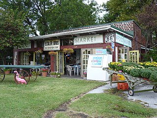
Williams' Store is a historic store located along Old U.S. Route 66 in Riverton, Kansas. Leo Williams built the store in 1925, the year before Route 66 was designated. The store had a gas station and sold a variety of goods. While it was mainly a grocery and general store, Williams and his wife Lora sold chili and barbecue beef to travelers on Route 66. The store even had a croquet court at one point, which hosted local tournaments. The court was eventually removed to add parking. Leo Williams leased the store to Lloyd Paxon in 1945; Leo died before the lease expired; his wife Lora ran the store until 1970.
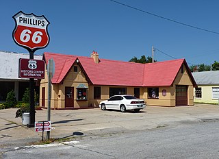
The Baxter Springs Independent Oil and Gas Service Station is a historic gas station located at 940 Military Avenue in Baxter Springs, Kansas, along the former route of U.S. Route 66. The station was built in 1930 by the Independent Oil and Gas Company; the company merged with Phillips Petroleum the following year, and the station became a Phillips 66 station. The station was designed in the Tudor Revival style so to resemble a small cottage; this style was popular among gas stations at the time, as oil companies wanted their stations to fit in with nearby residential architecture. An addition which served as an auto repair shop was added to the station between 1930 and 1942. Phillips operated the station until 1958, and it continued to sell gasoline until the 1970s. The building now serves as the Kansas Route 66 Visitors Center.
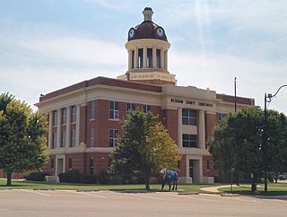
The Beckham County Courthouse, located in Courthouse Square in Sayre, is the county courthouse of Beckham County, Oklahoma. The courthouse is considered a local landmark because it is the tallest building in Sayre. It is also one of the few courthouses in Oklahoma that has a dome.
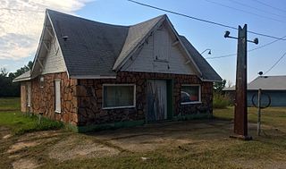
The Magnolia Service Station is a historic service station located on Old U.S. Route 66 in Texola, Oklahoma. The station, an affiliate of the Magnolia Petroleum Company, opened circa 1930. The station was one of the westernmost in Oklahoma and became one of the first stops for eastbound travelers to buy gas and auto services in the state. The main building of the service station is representative of the "house" style of filling station; such stations resembled small houses in order to fit into residential areas.
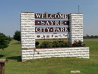
The Sayre City Park is a public park located along historic U.S. Route 66 on the south end of Sayre, Oklahoma. The park formally opened in 1940; however, the land had been owned by the city and used informally as a park for several years prior. The Works Progress Administration built the park's structures according to plans designed by J.N. Willis. The park's bathhouse and swimming pool, the dominant features of the park, have a Pueblo Revival design with ornamental vigas. Other park features include a miniature golf course, a gazebo, and tennis courts. The park attracted both locals and travelers on Route 66, who regularly camped in the park. A local business district also developed around the park, primarily to serve tourists.
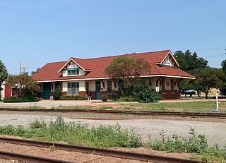
The Sayre Rock Island Depot is a historic railroad station located at 106 E. Poplar Ave. in Sayre, Oklahoma. The depot was built in 1927 along the Chicago, Rock Island and Pacific Railroad ; it replaced Sayre's original Rock Island station, which opened outside the town limits in 1901. The new station is just two blocks north of downtown Sayre. It accommodated the increased traffic the line had gained in the early 1920s; it also helped the railroad compete with the recently designated U.S. Route 66. The station building was built from and has an Italian Renaissance Revival design. Its design resembles two other surviving Rock Island stations in Oklahoma: the Hobart Depot and the Walters Depot.

The Sayre Downtown Historic District is a commercial historic district located in downtown Sayre, Oklahoma. The district comprises a three-block area of Main and 4th Streets; it includes 39 buildings, of which 24 are contributing buildings. The oldest buildings in the district date from between 1903 and 1909, when a building boom replaced Sayre's frame downtown buildings with brick Commercial style structures. By the 1920s, the downtown area had reached its current size, and most of the buildings in the district had been built. In the 1920s, U.S. Route 66 was routed through the district, increasing traffic for local businesses. Sayre's Classical Revival post office, a contributing property, was constructed in 1938; the post office includes a Works Progress Administration mural painted in 1940. The downtown remained prosperous until the 1950s, when population decline and the bypassing of Route 66 led to a decrease in commercial activity.
The Threatt Filling Station, at the southwestern corner of the former U.S. Route 66 and Pottawatomi Rd. about 3 miles (4.8 km) east of Luther, Oklahoma, is a filling station built around 1915. It was listed on the National Register of Historic Places in 1995.


