Texola, Oklahoma

Last updated

Texola, Oklahoma
5th Street, Texola Oklahoma.jpg
5th Street (Historic Route 66) in Texola
Nickname: 
Beerola
Beckham County Oklahoma incorporated and unincorporated areas Texola highlighted.svg
Location in Beckham County and the state of Oklahoma.
Coordinates: 35°13′21″N99°59′35″W / 35.22250°N 99.99306°W / 35.22250; -99.99306 [1]
CountryUnited States
State Oklahoma
County Beckham
Area
[2]
  Total0.61 sq mi (1.59 km2)
  Land0.61 sq mi (1.59 km2)
  Water0.00 sq mi (0.00 km2)
Elevation
[1]
2,152 ft (656 m)
Population
 (2020)
  Total43
  Density70.26/sq mi (27.11/km2)
Time zone UTC-6 (Central (CST))
  Summer (DST) UTC-5 (CDT)
ZIP code
73668
Area code 580
FIPS code 40-73150 [3]
GNIS feature ID2413380 [1]

Texola is a town in Beckham County, Oklahoma, United States. The population was 43 at the time of the 2020 census, [4] an increase over the 36 firgure from the 2010 census.

Contents

History

Magnolia Service Station Magnolia Service Station.jpg
Magnolia Service Station

The History of Texola dates back to the early 1900s. Before being named Texola, the town site had been called Texokla and Texoma. Because of its location near the 100th Meridian, the town was surveyed eight different times, which meant that some early residents lived in both Texas and Oklahoma without ever moving. [5] [6] Texola was originally part of northern Greer County until Beckham County was formed after Oklahoma gained statehood in 1907. [7] A post office was established in the community on December 12, 1901, with Reuben H. Grimes serving as the first postmaster. In 1902, the Choctaw, Oklahoma and Gulf Railroad (later owned by the Chicago, Rock Island and Pacific Railway) was built through the town. A weekly newspaper, the Texola Herald, began publishing in 1902 and continued to operate into the early 1920s. By 1909, Texola had two cotton gins as well as a corn and grist mill. The local economy was agriculturally based and several businesses opened in the community.

The 1910 census recorded 361 people living in Texola. That same year, a small Territorial Jail was built. [5] [6] [8] After a slight decline in population during the 1910s, Texola grew rapidly in the 1920s. The population peaked at 581 in the 1930 census. The arrival of Route 66 (also known as 5th Street) had a positive impact on the local economy. Cotton production increased during the decade, necessitating the need for two additional gins. As the town prospered, amenities such as a ten-acre park and an auditorium capable of seating 300 people were found in the community. [7] The population began to decline in the 1940s and continued to do so throughout the remainder of the twentieth century. By 1980, Texola was a town of 106 residents. When the next census was conducted in 1990, Texola had lost nearly 58 percent of its population, leaving just 45 people in the town. The figure is nearly the same in the 2020 census, at 43 people. [4]

Historic places

The Magnolia Service Station in Texola is listed on the National Register of Historic Places listings in Beckham County, Oklahoma, being placed on the list in 1995. The station was built in 1930 by the Magnolia Petroleum Company on Route 66. [9] [10] [11]

A quirky roadside attraction in Texola is the One Room Jail. [12] It was constructed in the late 1800s out of cinderblock, and consists of a single room with an iron-barred door and window. [12]

Geography

According to the United States Census Bureau, the town has a total area of 0.6 square miles (1.6 km2), all land.

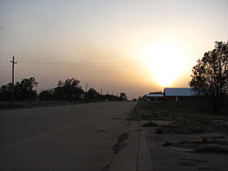
Texola is not directly served by the Oklahoma state highway system. However, the town can be accessed from I-40 Exit 1. [13] U.S. Route 66 passed through the town, bringing scores of travelers for decades, until I-40 was completed to the north in 1975.

Demographics

Historical population
CensusPop.Note
1910 361
1920 298−17.5%
1930 58195.0%
1940 337−42.0%
1950 265−21.4%
1960 202−23.8%
1970 144−28.7%
1980 106−26.4%
1990 45−57.5%
2000 474.4%
2010 36−23.4%
2020 4319.4%
U.S. Decennial Census [14]

As of the census [3] of 2000, there were 47 people, 21 households, and 14 families residing in the town. The population density was 76.3 inhabitants per square mile (29.5/km2). There were 32 housing units at an average density of 51.9 per square mile (20.0/km2). The racial makeup of the town was 65.96% White, 6.38% African American, 10.64% Native American, 8.51% Asian, and 8.51% from two or more races. Hispanic or Latino of any race were 2.13% of the population.

There were 21 households, out of which 23.8% had children under the age of 18 living with them, 52.4% were married couples living together, 9.5% had a female householder with no husband present, and 33.3% were non-families. 23.8% of all households were made up of individuals, and 14.3% had someone living alone who was 65 years of age or older. The average household size was 2.24 and the average family size was 2.57.

In the town, the population was spread out, with 17.0% under the age of 18, 4.3% from 18 to 24, 25.5% from 25 to 44, 31.9% from 45 to 64, and 21.3% who were 65 years of age or older. The median age was 46 years. For every 100 females, there were 104.3 males. For every 100 females age 18 and over, there were 105.3 males.

The median income for a household in the town was $32,500, and the median income for a family was $31,875. Males had a median income of $28,750 versus $0 for females. The per capita income for the town was $13,208. There were 7.7% of families and 23.1% of the population living below the poverty line, including 28.6% of under eighteens and 50.0% of those over 64.

Education

The town of Texola is served by Erick Public Schools district, [15] which is headquartered in the city of Erick. The district operates two campuses, an elementary school and a high school.

Related Research Articles

<span class="mw-page-title-main">Wheeler County, Texas</span> County in Texas, United States

Wheeler County is a county located in the U.S. state of Texas. As of the 2020 census, its population was 4,990. Its county seat is Wheeler. The county was formed in 1876 and organized in 1879. It is named for Royall Tyler Wheeler, a chief justice of the Texas Supreme Court.

<span class="mw-page-title-main">Beckham County, Oklahoma</span> County in Oklahoma, United States

Beckham County is a county located on the western border of the U.S. state of Oklahoma. As of the 2020 census, the population was 22,410. Its county seat is Sayre. Founded upon statehood in 1907, Beckham County was named for J. C. W. Beckham, who was Governor of Kentucky and the first popularly elected member of the United States Senate from Kentucky. Beckham County comprises the Elk City, OK Micropolitan Statistical Area.

<span class="mw-page-title-main">Peach Springs, Arizona</span> CDP in Mohave County, Arizona

Peach Springs is a census-designated place (CDP) in Mohave County, Arizona, United States. The population was 1,098 at the 2020 census. Peach Springs serves as the administrative headquarters of the Hualapai people and is located on the Hualapai Reservation.

<span class="mw-page-title-main">Magnolia, Delaware</span> Town in Delaware, United States

Magnolia is a town in Kent County, Delaware, United States. It is part of the Dover, Delaware Metropolitan Statistical Area. Recent estimates put the population at around 235, however, the population was 277 in 2020.

<span class="mw-page-title-main">Smithfield, Illinois</span> Village in Illinois, United States

Smithfield is a village in Fulton County, Illinois, United States. The population was 230 at the 2010 census. The village is named in honor of Dr. Joseph N. Smith.

<span class="mw-page-title-main">Duane, New York</span> Town in New York, United States

Duane is a town in Franklin County, New York, United States. The population was 174 at the 2010 census. The town is named after James Duane, a developer and grandson of New York City mayor James Duane.

Magnolia is a town in Duplin County, North Carolina, United States. The population was 939 at the 2010 census.

<span class="mw-page-title-main">Stringtown, Oklahoma</span> Town in Oklahoma, United States

Stringtown is a town in Atoka County, Oklahoma, United States. The population was 410 at the 2010 census, an increase of 3.5 percent from the figure of 396 recorded in 2000. It is the second largest town in Atoka County.

<span class="mw-page-title-main">Carter, Oklahoma</span> Town in Oklahoma, United States

Carter is a town in Beckham County, Oklahoma, United States. The population was 183 at the time of the 2020 census.

<span class="mw-page-title-main">Elk City, Oklahoma</span> City in Oklahoma, United States

Elk City is a city in Beckham County, Oklahoma, United States. The population was 11,561 at the time of the 2020 census, a slight decrease from the 11,693 figure of the 2010 census. Elk City is located on Interstate 40 and Historic U.S. Route 66 in western Oklahoma, approximately 110 miles (180 km) west of Oklahoma City and 150 miles (240 km) east of Amarillo, Texas.

<span class="mw-page-title-main">Erick, Oklahoma</span> City in Oklahoma, United States

Erick is a city in Beckham County, Oklahoma, United States. It is located 15 miles (24 km) west of Sayre, the county seat, and 6 miles (9.7 km) east of the Oklahoma-Texas border. The population was an even 1,000 at the time of the 2020 census.

<span class="mw-page-title-main">Sayre, Oklahoma</span> City in Oklahoma, United States

Sayre is a city in, and the county seat of, Beckham County, in western Oklahoma, United States. It is halfway between Oklahoma City and Amarillo, Texas on Interstate 40 and the former U.S. Route 66. The population was 4,809 at the time of the 2020 census, an increase over the 4,375 figure from the 2010 census, and the largest population ever recorded by a census since Sayre's founding.

<span class="mw-page-title-main">Arapaho, Oklahoma</span> Town in Oklahoma, United States

Arapaho is a town in, and the county seat of, Custer County, Oklahoma, United States. The population was 796 at the 2010 census, a 6.4 percent increase from the figure of 748 in 2000. The town lies long U.S. Route 183 and is named for the Arapaho Native American tribe.

Whitefield is a town in northwestern Haskell County, Oklahoma, United States. The population was 377 at the 2020 census, compared with the figure of 391 recorded in 2010. It was named for Methodist bishop George Whitefield.

<span class="mw-page-title-main">Summit, Oklahoma</span> Town in Oklahoma, United States

Summit is a town in Muskogee County, Oklahoma, United States. It was originally called South Muskogee when it was platted in 1910, and is one of thirteen all-black towns still surviving at the beginning of the 21st Century. The population was 139 at the 2010 census, a 38.5 percent decline from the figure of 226 recorded in 2000.

<span class="mw-page-title-main">Afton, Oklahoma</span> Town in Oklahoma, United States

Afton is a town in northeast Oklahoma in Ottawa County, Oklahoma, United States. The population was 1,049 as of the 2010 census, with population growth stemming from the near abandonment of nearby towns of Cardin and Picher because of ground contamination sites by local mining quarries. The town may have been named for the Scottish River Afton.

<span class="mw-page-title-main">Narcissa, Oklahoma</span> CDP in Oklahoma, United States

Narcissa is a census-designated place (CDP) in Ottawa County, Oklahoma, United States. The population was 100 at the 2000 census. Narcissa is part of the Joplin, Missouri metropolitan area.

St. Louis is a town in Pottawatomie County, Oklahoma, United States. The population was 158 at the 2010 census, a 23.3 percent decline from the figure of 206 in 2000.

<span class="mw-page-title-main">Turley, Oklahoma</span> CDP in Oklahoma, United States

Turley is a census-designated place (CDP) in Tulsa County, Oklahoma, United States. The population was 2,756 at the 2010 census, a loss of 14.7 percent from the figure of 3,231 recorded in 2000.

<span class="mw-page-title-main">Hydro, Oklahoma</span> Town in Oklahoma, United States

Hydro is a town in Caddo and Blaine counties in the U.S. state of Oklahoma. As of the 2010 census, the town population was 969.

References

  1. 1 2 3 U.S. Geological Survey Geographic Names Information System: Texola, Oklahoma
  2. "ArcGIS REST Services Directory". United States Census Bureau. Retrieved September 20, 2022.
  3. 1 2 "U.S. Census website". United States Census Bureau . Retrieved January 31, 2008.
  4. 1 2 "Texola (town), Oklahoma". United States Census Bureau. Retrieved August 29, 2023.
  5. 1 2 "Erick and Texola Oklahoma – Gateway to Oklahoma". Legends of America, A Travel Site for the Nostalgic & Historic Minded. Retrieved July 22, 2009.
  6. 1 2 "The Oklahoma Route 66 Journey (Part I, Texola to Elk City)". Oklahoma Tourism & Recreation Department. Retrieved July 22, 2009.
  7. 1 2 Wilson, Linda D. "Texola," Encyclopedia of Oklahoma History and Culture, Oklahoma Historical Society, 2009. Accessed April 15, 2015.
  8. "Shadows of Texola". The Road Wanderer. Retrieved July 22, 2009.
  9. nps.gov, Magnolia Service Station in Texola, Oklahoma
  10. Meacham, Maryjo; Peck, Brenda; Bradley, Lisa; Roth, Susan (May 31, 1992). "National Register of Historic Places Registration Form: Magnolia Service Station" (PDF). National Park Service. Retrieved April 20, 2014. Accompanied by photos.
  11. Meacham, Maryjo; Peck, Brenda; Bradley, Lisa; Roth, Susan. "National Register of Historic Places Multiple Property Documentation Form: Route 66 and Associated Historic Resources in Oklahoma" (PDF). National Park Service. Retrieved April 20, 2014.
  12. 1 2 "One Room Jail". TravelOK.com. Retrieved October 22, 2021.
  13. Official State Map (Map) (2008 ed.). Oklahoma Department of Transportation.
  14. "Census of Population and Housing". Census.gov. Retrieved June 4, 2015.
  15. "Homepage". Erick Public Schools. Retrieved October 22, 2021.