Schick models of Jerusalem

Last updated

Schick's model of Herod's Temple on the Temple Mount, Schmidt's Girls College, Jerusalem, with portrait of Schick in the background Conrad schik6070220.JPG
Schick's model of Herod's Temple on the Temple Mount, Schmidt's Girls College, Jerusalem, with portrait of Schick in the background
Schick's model of Temple Mount foundations Conrad Schick model of Temple Mount foundations, cropped from Fotografi fran Jerusalem pa modell - Hallwylska museet - 104360 (cropped).tif
Schick's model of Temple Mount foundations

The Schick models of Jerusalem are notable wooden models of buildings and areas in the city of Jerusalem constructed by Conrad Schick in the late 19th century. The series of models covered the Church of the Holy Sepulchre, the Islamic buildings of Al-Aqsa on the Temple Mount and the terrain beneath it, as well as replicas of the Jewish Temple based on the information available in his time, and benefitting from his architectural knowledge. [1]

Contents

Schick's monograph on the Temple Mount, Die Stiftshütte ("The Tabernacle"), is primarily a commentary on his models. [2] [1]

Temple Mount (Haram) models

At Paulus-Haus, Jerusalem Temple Mount Model P6080074.JPG
At Paulus-Haus, Jerusalem
At Christ Church, Jerusalem Christ Church Jerusalem 22.jpg
At Christ Church, Jerusalem
At the Bijbels Museum, Amsterdam Tempelberg-biblicalmuseum.JPG
At the Bijbels Museum, Amsterdam

Schick's most notable models were of the Temple Mount, which he described as the Haram. [3] Schick's models of the area, particularly of the foundations of the platform, are important to scholars of the area, because Schick was the last European in modern history to be allowed to carry out an archaeological survey of the subterranean spaces beneath the buildings of Al-Aqsa. [4] [1] Archaeology or surveying has rarely been permitted in the Temple Mount area, due to religious sensitivities. [5] Only four such surveys of the area as a whole are known from modern times; those of Charles William Wilson, Charles Warren, Claude Reignier Conder, and Conrad Schick, with Schick's access being the most recent and with the broadest access. [6] Schick's access was unique, because he was working to build his model for the Ottoman government [7] during a period in which structural repairs were being made; [8] the models were procured for and exhibited in the Turkish pavilion at the Vienna World Exposition of 1873, alongside the Illés Relief. [3] [9]

The first two models were made for the 1873 World's Fair; [4] the smaller initial model likely as part of the competition to win the contract from the Ottoman authorities. [10] The exhibited model, measuring 4 by 3 meters, was visited in Jerusalem by several crowned heads of state and toured the United Kingdom after the World's Fair, [11] but did not find a buyer. It was housed at the Theologisches Seminar St. Chrischona near Basel, Switzerland, for 138 years, until 2012 when it was purchased by Christ Church in the Old City of Jerusalem. [12]

Schick built further replicas of the Temple Mount for the Ottoman Sultan in 1885. This final model, in four sections, each representing the Temple Mount as it appeared in a particular era, was exhibited at the 1904 Louisiana Purchase Exposition. [11] Two of these models are located in the basement of the Paulus-Haus museum on Nablus Road, just outside the Old City of Jerusalem near the Damascus Gate, and a third is in the Bijbels Museum, Amsterdam. [3]

DateSubjectSize (cm)ScaleNumber madeCurrent location
1872–3?Temple Mount82 × 48 × 9.5 ? ? Palestine Exploration Fund, London [10]
1873Temple Mount400 x 3001:200oneChrist Church, Jerusalem (previously at St Chrischona Mission)
1885Temple Mount (in various periods)260 × 1681:200at least four, three are still knownone in the Bijbels Museum, Amsterdam; two in Paulus-Haus, Jerusalem

Jerusalem topography models

DateSubjectSize (cm)ScaleNumber madeCurrent location
1865Altmüller's second model of Jerusalem25.5 × 32.71:21,600many copiesvarious
1871Topography of Jerusalem65 × 91.5 x 231:2,500 (1:1,250 vertical)one?unknown
1895Topography of Jerusalem85 × 991:2,500 ? German Protestant Institute, Jerusalem

Individual building models

Tabernacle

DateScaleNumber madeCurrent location
c. 18451:20oneunknown
1862/31:18several?unknown

Church of the Holy Sepulchre

DateSize (cm)ScaleNumber madeCurrent location
1862/3132 × 1751:96at least four Christ Church, Jerusalem
189678 × 1371:200at least twoGerman Evangelical Institute, Jerusalem

Dome of the Rock

One model of the Dome of the Rock, made for the 1873 world's fair. Originally at the St Chrischona Mission, it was sold to an unknown buyer in 2013 for £242,000. [13] [14]

DateScaleNumber madeCurrent location
18731:50oneunknown

Church of the Nativity

Model of the Church of the Nativity

DateScaleNumber madeCurrent location
18741:70 ?unknown

Christ Church

DateSize (cm)ScaleNumber madeCurrent location
1870–187591.5 × 94 ?oneChrist Church, Jerusalem

Bibliography

Related Research Articles

<span class="mw-page-title-main">Temple Mount</span> Religious site in Jerusalem

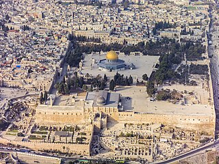
The Temple Mount, also known as Haram al-Sharif, al-Aqsa Mosque compound, or simply al-Aqsa, and sometimes as Jerusalem's holyesplanade, is a hill in the Old City of Jerusalem that has been venerated as a holy site in Judaism, Christianity, and Islam for thousands of years.

<span class="mw-page-title-main">Tower of David</span> Ancient citadel in the Old City of Jerusalem

The Tower of David, also known as the Citadel, is an ancient citadel located near the Jaffa Gate entrance to the Old City of Jerusalem.

<span class="mw-page-title-main">Palestine Exploration Fund</span> British society founded in 1865

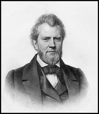
The Palestine Exploration Fund is a British society based in London. It was founded in 1865, shortly after the completion of the Ordnance Survey of Jerusalem by Royal Engineers of the War Department. The Fund is the oldest known organization in the world created specifically for the study of the Levant region, also known as Palestine. Often simply known as the PEF, its initial objective was to carry out surveys of the topography and ethnography of Ottoman Palestine – producing the PEF Survey of Palestine. Its remit was considered to fall between an expeditionary survey and military intelligence gathering. There was also strong religious interest from Christians; William Thomson, Archbishop of York, was the first President of the PEF.

<span class="mw-page-title-main">The Garden Tomb</span> Ancient tomb in Jerusalem of possible Biblical significance

<span class="mw-page-title-main">Sar'a</span> Place in Jerusalem, Mandatory Palestine

Sar'a, was a Palestinian Arab village located 25 km west of Jerusalem, depopulated in the 1948 war. The site lies on a hill, at an elevation of about 1,150 feet (350 m) above sea-level.

<span class="mw-page-title-main">Kudna</span> Place in Hebron, Mandatory Palestine

Kudna was a Palestinian Arab village, located 25 kilometers northwest of Hebron.

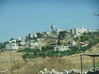
Muqeible or Muqeibla, meaning "The front place", is an Arab town in Israel's Northern District, situated in the Jezreel Valley between Jenin in the West Bank and the Ta'anakh area. It is a part of the Gilboa Regional Council.In 2021 its population was 4,260. The inhabitants are Muslims and Christians.

<span class="mw-page-title-main">Beit Liqya</span> Municipality type C in Ramallah and al-Bireh, State of Palestine

Beit Liqya is a Palestinian town located in the Ramallah and al-Bireh Governorate in the northern West Bank. According to the Palestinian Central Bureau of Statistics, it had a population of approximately 9,304 in 2017.

<span class="mw-page-title-main">Saffa, Ramallah</span> Town in the West Bank, State of Palestine

Saffa is a Palestinian town in the Ramallah and al-Bireh Governorate, located west of Ramallah in the northern West Bank. According to the Palestinian Central Bureau of Statistics (PCBS), the town had a population of 4,374 inhabitants in 2017.

<span class="mw-page-title-main">Mukhmas</span> Municipality type D in Jerusalem, State of Palestine

Mukhmas, in the Spanish transcriptions Mujmas, is a Palestinian village in the Jerusalem Governorate, located northeast of Jerusalem, in the center of the West Bank. According to the Palestinian Central Bureau of Statistics, the town had a population of 1,363 in 2017.

<span class="mw-page-title-main">Ubeidiya, West Bank</span> Palestinian town on the West Bank

Al-Ubeidiya is a Palestinian town located 6 kilometers (3.7 mi) east of Bethlehem. The town is a part of the Bethlehem Governorate in the central West Bank. According to the Palestinian Central Bureau of Statistics (PCBS), al-Ubeidiya had a population of over 14,460 in 2017.

<span class="mw-page-title-main">Nabi Rubin</span> Place in Ramle, Mandatory Palestine

Al-Nabi Rubin was a Palestinian village in central Palestine region, what is now Israel, located 14.5 kilometers (9.0 mi) west of Ramla, just northeast of Yibna and 18 kilometers (11 mi) south of Jaffa. The village was situated on the southern banks of Wadi al-Sarar, known in Hebrew as Sorek Stream, at an elevation of 25 meters (82 ft) above sea level. Nabi Rubin is named after a shrine in the village, believed by Muslims to be the tomb of Reuben, first son of Jacob. It was captured by the Israel Defense Forces during the 1948 Arab-Israeli War, and the inhabitants were expelled.

<span class="mw-page-title-main">Deir Nidham</span> Municipality type D in Ramallah and al-Bireh, State of Palestine

Deir Nidham is a Palestinian village in the Ramallah and al-Bireh Governorate in the central West Bank. It is located approximately 23 kilometers (14 mi) northwest of the city of Ramallah and its elevation is 590 meters (1,940 ft). According to the Palestinian Central Bureau of Statistics (PCBS) 2017 census, the town had a population of 876.

Replicas of the Jewish Temple are scale models or authentic buildings that attempt to replicate the Temple of Solomon, the Second Temple and Herod's Temple in Jerusalem.

<span class="mw-page-title-main">Conrad Schick</span> German architect (1822–1901)

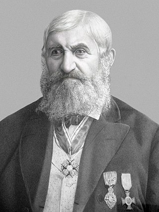
Conrad Schick (1822–1901) was a German architect, archaeologist and Protestant missionary who settled in Jerusalem in the mid-nineteenth century. For many decades, he was head of the "House of Industry" at the Christ Church, which was the institute for vocational training of the London Society for Promoting Christianity Amongst the Jews.

<span class="mw-page-title-main">Dayr Aban</span> Place in Jerusalem, Mandatory Palestine

Dayr Aban was a Palestinian Arab village in the Jerusalem Subdistrict, located on the lower slope of a high ridge that formed the western slope of a mountain, to the east of Beit Shemesh. It was formerly bordered by olive trees to the north, east, and west. The valley, Wadi en-Najil, ran north and south on the west-side of the village. It was depopulated during the 1948 Arab-Israeli War on October 19, 1948, during Operation Ha-Har. It was located 21 km west of Jerusalem. Today there are over 5000 people originally from Dayr Aban living in Jordan.

<span class="mw-page-title-main">Illés Relief</span>

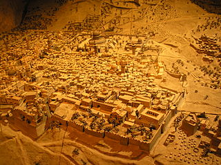
Illés Relief is a 1:500 scale model of the city of Jerusalem, built for the Ottoman Pavilion at the 1873 Vienna World's Fair.

<span class="mw-page-title-main">Al-Ram</span> Municipality type B in Jerusalem, State of Palestine

Al-Ram, also transcribed as Al-Ramm, El-Ram, Er-Ram, and A-Ram, is a Palestinian town which lies northeast of Jerusalem, just outside the city's municipal border. The village is part of the built-up urban area of Jerusalem, the Atarot industrial zone and Beit Hanina lie to the west, and Neve Yaakov borders it on the south, with a built-up area of 3,289 dunums. According to the Palestinian Central Bureau of Statistics, a-Ram had a population of 15,814 in 2017. The head of A-Ram's village council estimates that 58,000 people live there, more than half of them holding Israeli identity cards.

<span class="mw-page-title-main">Ordnance Survey of Jerusalem</span> 1864–65 mapping of Jerusalem

The Ordnance Survey of Jerusalem of 1864–65 was the first scientific mapping of Jerusalem, and the first Ordnance Survey to take place outside the United Kingdom. It was undertaken by Charles William Wilson, a 28-year-old officer in the Royal Engineers corps of the British Army, under the authority of Sir Henry James, as Superintendent of the Ordnance Survey, and with the sanction of George Robinson, 1st Marquess of Ripon as Secretary of State for War. The team of six Royal Engineers began their work on 3 October 1864. The work was completed on 16 June 1865, and the report was published on 29 March 1866.

<span class="mw-page-title-main">James Turner Barclay</span> American Biblical scholar (1807-1874)

James Turner Barclay was an American missionary and explorer of Palestine.

References

  1. 1 2 3 Gibson & Jacobson 1994.
  2. Schick 1896, p. III-IV, 55.
  3. 1 2 3 Goren & Rubin 1996, p. 103–124.
  4. 1 2 Friedman, Matti (5 February 2012). "After 130 years, a tiny Temple Mount comes home". The Times of Israel. Retrieved 2 September 2023.
  5. Gibson & Jacobson 1994 "Religious sensitivities have discouraged scientific investigation of subterranean features within the Haram al-Sharif in Jerusalem, which incorporates the area of the ancient Temple Mount. In consequence, the mystery of this sacred place has been heightened, providing fertile ground for flights of fancy concerning the two Jewish temples that formerly occupied the site. Even serious scholars have had to make do with hypotheses concerning the position and layout of these ancient complexes… However, for a brief period in the second half of the nineteenth century a handful of intrepid European explorers, in particular Charles Wilson, Charles Warren, Claude Regnier Conder, and Conrad Schick, succeeded in lifting this veil of secrecy and visited many of the underground chambers that pepper this sacred site."
  6. Gibson & Jacobson 1994 "They left records of some 45 subterranean chambers that they classified as cisterns as well as other cavities and structural remains. Much of this material was published by them (Wilson 1866: 42–45; Warren 1871:204-17; Warren and Conder 1884; Schick 1887:72–87; 1896: 292–305), but many important details were confined to manuscript and deposited in the archives of the Palestine Exploration Fund (PEF) in London. Some of the most reliable and detailed information was recorded by the German-born Conrad Schick… Yet, Schick, with his sharp eye for detail, subsequently provided superior information about the subterranean cisterns of the Haram."
  7. Gibson & Jacobson 1994 "Normally, the interior of the Haram was kept out of bounds to explorers, but in 1872 Schick was afforded a golden opportunity to investigate this area. Turkey wished to be represented at the Great Exhibition to be held in Vienna, and the Austrian consul in Jerusalem persuaded them to put on display there a detailed model of the Haram al-Sharif. As Schick related in a letter to Charles Wilson, dated 7 June 1872, he was awarded the assignment of producing a suitable model in wood at a reasonable cost. He wanted his model to be of value to "students of history and topography" and not merely a display of craftsmanship. It was exhibited with another model in the Turkish pavilion at the Vienna Exhibition of 1873 and later they were sold by his agent, Rev. J.H. Brühl, to the Mission House Museum in Basle, Switzerland, as we are informed in letters from Schick to Wilson, written between 16 June, 1873 and 23 April 1874. Schick was determined to depict "the substructions (sic), cisterns and all underground buildings as well as those above ground". He thereupon set about examining and recording as many of the subterranean features as he was able, during the years 1873 and 1875, and continued making models."
  8. Gibson & Jacobson 1994 "This was a period when much needed repairs were being made to the Dome of the Rock by the Ottoman Turkish authorities which brought builders and engineers into the Haram. These circumstances made it easier for Schick to gain access to areas normally barred to foreigners. He was able to observe digging operations and the clearance of blocked underground channels. Several of the cisterns were visited and recorded by him at this time."
  9. Zschokke 1874, pp. 4–9
  10. 1 2 Rubin 2006, pp. 46–50.
  11. 1 2 Goldhill, Simon (2005). The Temple of Jerusalem. Wonders of the world. Harvard University Press. p. 129. ISBN   978-0-674-01797-9 . Retrieved 2 September 2023. …he was renowned for constructing large-scale wooden models of the city and its monuments. He built a model of the Tabernacle, which was visited in Jerusalem by the Prussian crown prince and the Austrian emperor, before successfully touring the British Isles ('bringing the Holy Land to those who cannot visit it: the exhibition was counted a great success by his missionary employers). After it was exhibited at the 1873 World's Fair at Vienna, his model of the Holy Sepulchre was bought by the king of Württemberg, who rewarded him with a knighthood. He was also commissioned by the Sultan of the Ottoman Empire for a model of the Temple Mount for the same exhibition, as he wrote proudly to Captain Wilson, of Wilson's Arch renown (which other archaeologists hoped vainly would open access to hitherto forbidden areas). But the crowning glory of his career was a further model of the Temple Mount in four sections, each of which represented a different period. It could be taken apart and put together to show the topography of the site, Solomon's Temple, the destruction and reconstruction by 'Zerubbabel and Herod, and finally the Muslim Haram al-Sharif. It was built in 1885 and exhibited posthumously at the World's Fair at St Louis in 1904, where it was sold for the huge sum of £800.
  12. Hasson, Nir (15 February 2012). "Tiny Model of Temple Mount Returns to Jerusalem – Haaretz.com". Haaretz.com. Retrieved 2 September 2023.
  13. Magouliotis 2021.
  14. al-Jubeh 2016, p. 11, 16.