
The Great Pyramid of Giza is the largest Egyptian pyramid. It served as the tomb of pharaoh Khufu, who ruled during the Fourth Dynasty of the Old Kingdom. Built c. 2600 BC, over a period of about 26 years, the pyramid is the oldest of the Seven Wonders of the Ancient World, and the only wonder that has remained largely intact. It is the most famous monument of the Giza pyramid complex, which is part of the UNESCO World Heritage Site "Memphis and its Necropolis". It is situated at the northeastern end of the line of the three main pyramids at Giza.

The Western Wall (Hebrew: הַכּוֹתֶל הַמַּעֲרָבִי, romanized: HaKotel HaMa'aravi, lit. 'the western wall', is an ancient retaining wall of the built-up hill known to Jews and Christians as the Temple Mount of Jerusalem. Its most famous section, known by the same name, often shortened by Jews to the Kotel or Kosel, is known in the West as the Wailing Wall, and in Islam as the Buraq Wall. In a Jewish religious context, the term Western Wall and its variations is used in the narrow sense, for the section used for Jewish prayer; in its broader sense it refers to the entire 488-metre-long retaining wall on the western side of the Temple Mount.
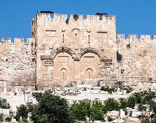
The Golden Gate or Gate of Mercy is the only eastern gate of the Temple Mount, and one of only two Gates of the Old City of Jerusalem that used to offer access into the city from the East side.
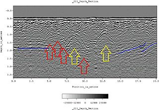
Ground-penetrating radar (GPR) is a geophysical method that uses radar pulses to image the subsurface. It is a non-intrusive method of surveying the sub-surface to investigate underground utilities such as concrete, asphalt, metals, pipes, cables or masonry. This nondestructive method uses electromagnetic radiation in the microwave band of the radio spectrum, and detects the reflected signals from subsurface structures. GPR can have applications in a variety of media, including rock, soil, ice, fresh water, pavements and structures. In the right conditions, practitioners can use GPR to detect subsurface objects, changes in material properties, and voids and cracks.

The Tower of David, also known as the Citadel, is an ancient citadel and contemporary museum, located near the Jaffa Gate entrance to the Old City of Jerusalem.

The Tunnel of Eupalinos or Eupalinian aqueduct is a tunnel of 1,036 m (3,399 ft) length running through Mount Kastro in Samos, Greece, built in the 6th century BC to serve as an aqueduct. The tunnel is the second known tunnel in history which was excavated from both ends, and the first with a geometry-based approach in doing so. Today it is a popular tourist attraction. The tunnel is inscribed on the UNESCO World Heritage List along with the nearby Pythagoreion and Heraion of Samos, and it was designated as an International Historic Civil Engineering Landmark in 2017.

Solomon's Stables, or Al-Marwani Mosque, is an underground vaulted prayer hall in the Al-Aqsa mosque compound in Jerusalem. It is 600 square yards in area, and is located under the southeastern corner of the compound, 12.5 m (41 ft) below the courtyard, and features twelve rows of pillars and arches. In December 1996 the Jerusalem Waqf renovated the area. The area was known to the Crusaders as Solomon's Stables, and to earlier Muslims as the Old Mosque.
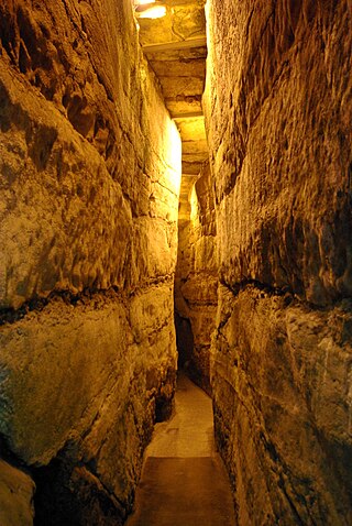
The Western Wall Tunnel is a tunnel exposing the Western Wall slightly north from where the traditional, open-air prayer site ends and up to the Wall's northern end. Most of the tunnel is in continuation of the open-air Western Wall and is located under buildings of the Muslim Quarter of the Old City of Jerusalem. While the open-air portion of the Western Wall is approximately 60 metres (200 ft) long, the majority of its original length of 488 metres (1,601 ft) is hidden underground. The tunnel allows access to the remainder of the Wall in a northerly direction.

Meleke, also transliterated melekeh or malaki, is a lithologic type of white, coarsely-crystalline, thickly bedded-limestone found in the Judaean Mountains in Israel. It has been used in the traditional architecture of Jerusalem since ancient times, especially in Herodian architecture. Though it is often popularly referred to as Jerusalem stone, that phrase can refer to a number of different types of stone found and used in or associated with Jerusalem.
Herodian architecture is a style of classical architecture characteristic of the numerous building projects undertaken during the reign of Herod the Great, the Roman client king of Judea. Herod undertook many colossal building projects, most famously his reconstruction of the Temple in Jerusalem. Many of his structures were built upon comparable, previous Hasmonean buildings and most of his have, in their turn, vanished as well.

A number of archaeological excavations at the Temple Mount—a celebrated and contentious religious site in the Old City of Jerusalem—have taken place over the last 150 years. Excavations in the area represent one of the more sensitive areas of all archaeological excavations in Jerusalem.

The Hasmonean Baris was a citadel constructed north of Jerusalem's Temple Mount in existence during the Hasmonean period.

Robinson's Arch was a monumental staircase carried by an unusually wide stone arch, which once stood at the southwestern corner of the Temple Mount. It was built as part of the expansion of the Second Temple initiated by Herod the Great at the end of the 1st century BCE. Recent findings suggest that it may not have been completed until at least 20 years after his death. The massive stone span was constructed along with the retaining walls of the Temple Mount. It carried traffic up from ancient Jerusalem's Lower Market area and over the Tyropoeon street to the Royal Stoa complex on the esplanade of the Mount. The overpass was destroyed during the First Jewish–Roman War, only a few decades after its completion.

The Baalbek Stones are six massive Roman worked stone blocks in Baalbek, Lebanon, characterised by a megalithic gigantism unparallelled in antiquity.

The Southern Wall is the retaining wall of the Temple Mount at the southern end. It was built during King Herod's expansion of the Temple Mount platform southward on to the Ophel.

The Struthion Pool, effectually translated from the Greek as 'Sparrow Pool' is a large cuboid cistern beneath the Convent of the Sisters of Zion in the Old City of Jerusalem, built by Herod the Great in the first century BCE.

Wilson's Arch is the modern name for an ancient stone arch in Jerusalem, the first in a row of arches that supported a large bridge connecting the Herodian Temple Mount with the Upper City on the opposite Western Hill. The Arch springs from the Western Wall and is still visible underneath later buildings set against the Wall. The name Wilson's Arch is also used to denote the hall that it partially covers, which is currently used as a synagogue. This hall opens towards the Western Wall Plaza at the Plaza's northeast corner, so that it appears on the left of the prayer section of the Western Wall to visitors facing the Wall.

Dan Bahat is an Israeli archaeologist especially known for his excavations in Jerusalem, particularly at the Western Wall tunnels.

The Western Wall Plaza is a large public square situated adjacent to the Western Wall in the Jewish Quarter of the Old City of Jerusalem. It was formed in 1967 as a result of the razing of the Mughrabi Quarter neighborhood at the very end of the Six-Day War.
