
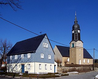
Bad Gottleuba-Berggießhübel is a spa town in the district Sächsische Schweiz-Osterzgebirge in the Free State of Saxony, Germany. The municipality borders the Czech Republic in the south. The municipality was formed on 1 January 1999 by the merger of the former municipalities Bad Gottleuba, Berggießhübel, Langenhennersdorf and Bahratal. Surrounded by forests and near a water dam Bad Gottleuba-Berggießhübel has several facilities, including a spa health park, a plant garden and a heated open air pool.

Reichenbach im Vogtland is a town in the Vogtlandkreis district of Saxony in eastern Germany. With a population of 20,928 (2017-09-30), it is the second largest town in the Vogtlandkreis after Plauen. It lies by the A72 between Plauen and Zwickau.

Mittweida is a town in the Free State of Saxony, Germany, in the Mittelsachsen district.

Weißwasser is a town in Upper Lusatia in eastern Saxony, Germany.

Werdau is a town in Germany, part of the Landkreis Zwickau in the Free State of Saxony. It is situated on the river Pleiße, 8 km from Zwickau.
Haselbachtal is a municipality in the district of Bautzen in the Free State of Saxony, Germany with a population of 4,648. It consists of the villages Bischheim, Häslich, Gersdorf, Möhrsdorf, Reichenau, and Reichenbach.

Borna is a town in the Free State of Saxony, Germany, capital of the Leipzig district. It is situated approximately 30 km southeast of Leipzig city. It has approx. 19,000 inhabitants. The town is the district seat of the district of Leipzig.

Markranstädt is a town in the Leipzig district, in the Free State of Saxony, Germany. It is situated 11 km southwest of the city of Leipzig and has close to 15,000 inhabitants.

Bernsdorf is a town with 6,427 inhabitants in the district of Bautzen, in the Free State of Saxony, Germany. It is 12 kilometres (7.5 mi) north of Kamenz and 15 kilometres (9.3 mi) southwest of Hoyerswerda. The town Bernsdorf consists of Bernsdorf proper and the Ortschaften Großgrabe, Straßgräbchen, Wiednitz and Zeißholz.

Brand-Erbisdorf is a small town in the district of Mittelsachsen, in the Free State of Saxony, Germany. It is situated 5 km south of Freiberg. As of 2017, the town has a population of 9,544.

Frauenstein is a town in the district of Mittelsachsen, in the Free State of Saxony, Germany. It is situated in the eastern Ore Mountains, 19 km (11.81 mi) southeast of Freiberg, and 33 km (20.51 mi) southwest of Dresden.

Frohburg is a town in the Leipzig district, in the Free State of Saxony, Germany. It is situated 11 km northeast of Altenburg, and 34 km southeast of Leipzig. It includes the village of Flößberg and the town Kohren-Sahlis.
Klingenthal is a town in the Vogtland region, in the Free State of Saxony, south-eastern Germany. It is situated directly on the border with the Czech Republic opposite the Czech town of Kraslice, 29 km southeast of Plauen, and 33 km northwest of Karlovy Vary.

Königsbrück is a town in the Bautzen district, in the Free State of Saxony, Germany. It is situated 14 km (8.7 mi) west of Kamenz, and 27 km (17 mi) northeast of the Saxon capital Dresden. Königsbrück is known as the western gate of the historic Upper Lusatia region.

Netzschkau is a town in the Vogtlandkreis district, in the Free State of Saxony, Germany. It is situated 6 km southeast of Greiz, and 21 km southwest of Zwickau.

Oederan is a town in the district of Mittelsachsen, in the Free State of Saxony, Germany.

Thum is a small town in the district of Erzgebirgskreis, in the Free State of Saxony, Germany. Thum has a population of about 5800.
Waldheim is a town in Mittelsachsen district, in Saxony, Germany.

Geyer is a town in the district of Erzgebirgskreis, in Saxony, Germany. It has a population of about 4000.

Belgershain is a town in the Leipzig district in Saxony. It is part of the municipal association of Naunhof.


