Scotch Bonnet Mountain

Last updated
Scotch Bonnet Mountain
Scotch Bonnet Mountain.jpg
West aspect
Highest point
Elevation 10,385 ft (3,165 m) [1]
Prominence 511 ft (156 m) [1]
Parent peak Sheep Mountain [2]
Isolation 1.12 mi (1.80 km) [2]
Coordinates 45°04′25″N109°57′01″W / 45.0734789°N 109.9501885°W / 45.0734789; -109.9501885 [3]
Geography
USA Montana relief location map.jpg
Red triangle with thick white border.svg
Scotch Bonnet Mountain
Location in Montana
Usa edcp relief location map.png
Red triangle with thick white border.svg
Scotch Bonnet Mountain
Scotch Bonnet Mountain (the United States)
CountryUnited States
State Montana
County Park
Parent range Beartooth Mountains
Rocky Mountains
Topo map USGS Cooke City
Geology
Age of rock 55.3 ± 0.7 million years [4]
Type of rock Diorite, Monzodiorite

Scotch Bonnet Mountain is a 10,385-foot (3,165-metre) summit in Park County, Montana, United States.

Contents

Description

Scotch Bonnet Mountain is located four miles (6.4 km) north of Cooke City, Montana, in the Beartooth Mountains which are a subrange of the Rocky Mountains. [1] It is set within the New World Mining District and the Custer-Gallatin National Forest. [2] Precipitation runoff from the mountain's south slope drains into headwaters of Fisher Creek which is a tributary of the Clarks Fork Yellowstone River, whereas the north slope drains into Goose Creek which is a tributary of the nearby Stillwater River. Topographic relief is significant as the summit rises approximately 1,760 feet (536 meters) above Goose Creek in 1.2 miles (1.9 km). The mountain's rock composition ranges from diorite to monzodiorite and is commonly propylitized. [4] The Montana Scotch Bonnet Copper and Gold Mining Company worked this area near Lulu Pass in the early 1900s and the mountain's toponym has been officially adopted by the United States Board on Geographic Names. [3] [5] [6] The area from Cooke City to Scotch Bonnet Mountain offers some of the finest backcountry snowmobiling in the country. [7] On January 3, 2010, two snowmobilers riding on the south face of Scotch Bonnet Mountain triggered an avalanche resulting in one fatality. [8] An avalanche on the mountain killed two snowmobilers on December 27, 2021. [9]

Climate

Based on the Köppen climate classification, Scotch Bonnet Mountain is located in a subarctic climate zone characterized by long, usually very cold winters, and mild summers. [10] Winter temperatures can drop below 0 °F with wind chill factors below −10 °F.

See also

Related Research Articles

<span class="mw-page-title-main">Bannock Peak</span> Mountain in Wyoming, United States

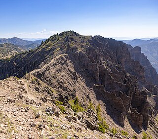
Bannock Peak is a 10,329-foot (3,148-metre) mountain summit in the southern section of the Gallatin Range in Yellowstone National Park, in the U.S. state of Wyoming. The peak ranks as the sixth-highest peak in the Gallatin Range. Precipitation runoff from the mountain drains west into headwaters of the Gallatin River and east into Panther Creek which is a tributary of the Gardner River. Topographic relief is significant as the summit rises nearly 2,000 feet above Panther Creek in one mile (1.6 km). This mountain's toponym was officially adopted in 1897 by the United States Board on Geographic Names.

<span class="mw-page-title-main">Cutoff Mountain</span> Mountain in the American state of Montana

Cutoff Mountain is a 10,695-foot (3,260-metre) mountain summit located in Park County, Montana.

<span class="mw-page-title-main">Lonesome Mountain</span> Mountain in Montana, United States

Lonesome Mountain is an 11,399-foot (3,474-metre) mountain summit located in Carbon County, Montana.

<span class="mw-page-title-main">Black Mountain (Montana)</span> Summit in Montana, United States

Black Mountain is a 10,941-foot (3,335-metre) summit located in Park County, Montana, United States.

<span class="mw-page-title-main">Beehive Peak</span> Summit in Madison County, Montana, United States

Beehive Peak is a 10,740-foot (3,274-metre) summit located in Madison County, Montana, United States.

<span class="mw-page-title-main">Mount Delano</span> Mountain in Montana, United States

Mount Delano is a 10,159-foot (3,096-metre) mountain summit in Park County, Montana, United States.

<span class="mw-page-title-main">Boat Mountain</span> Mountain in Montana, United States

Boat Mountain is a 9,071-foot (2,765-metre) mountain summit in Gallatin County, Montana, United States.

<span class="mw-page-title-main">Ross Peak</span> Mountain in Montana, United States

Ross Peak is a 9,008-foot-elevation (2,746-meter) mountain summit in Gallatin County, Montana, United States.

<span class="mw-page-title-main">Hardscrabble Peak</span> Mountain in Montana, United States

Hardscrabble Peak is a 9,571-foot-elevation (2,917-meter) mountain summit in Gallatin County, Montana, United States.

<span class="mw-page-title-main">Pomp Peak</span> Mountain in Montana, United States

Pomp Peak is a 9,576-foot-elevation (2,919-meter) mountain summit in Gallatin County, Montana, United States.

<span class="mw-page-title-main">Mount Bole</span> Mountain in Montana, United States

Mount Bole is a 10,339-foot (3,151-metre) mountain summit in Gallatin County, Montana, United States.

<span class="mw-page-title-main">Sheep Mountain (Park County, Montana)</span> Mountain in Montana, United States

Sheep Mountain is a 10,552-foot (3,216-metre) mountain summit in Park County, Montana, United States.

<span class="mw-page-title-main">Big Horn Peak</span> Mountain in Montana, United States

Big Horn Peak is a 9,935-foot (3,028-metre) mountain summit in Gallatin County, Montana, United States.

<span class="mw-page-title-main">Ramshorn Peak (Montana)</span> Mountain in Montana, United States

Ramshorn Peak is a 10,296-foot (3,138-metre) mountain summit in Gallatin County, Montana, United States.

<span class="mw-page-title-main">Steamboat Mountain (Gallatin County, Montana)</span> Mountain in Montana, United States

Steamboat Mountain is a 10,030-foot (3,057-metre) mountain summit in Gallatin County, Montana, United States.

<span class="mw-page-title-main">Sheep Mountain (Gallatin Range, Montana)</span> Mountain in Montana, United States

Sheep Mountain is a 10,097-foot (3,078-metre) mountain summit in Park County, Montana, United States.

<span class="mw-page-title-main">Fisher Mountain</span> Mountain in Montana, United States

Fisher Mountain is a 10,246-foot (3,123-metre) summit in Park County, Montana, United States.

<span class="mw-page-title-main">Sheep Mountain (Beartooth Mountains)</span> Mountain in Montana, United States

Sheep Mountain is a 10,608-foot (3,233-metre) summit in Park County, Montana, United States.

<span class="mw-page-title-main">Henderson Mountain</span> Mountain in Montana, United States

Henderson Mountain is a 10,343-foot (3,153-metre) summit in Park County, Montana, United States.

<span class="mw-page-title-main">Miller Mountain (Park County, Montana)</span> Mountain in Montana, United States

Miller Mountain is a 10,494-foot (3,199-metre) summit in Park County, Montana, United States.

References

  1. 1 2 3 "Scotch Bonnet Mountain, Montana". Peakbagger.com. Retrieved 2024-08-03.
  2. 1 2 3 "Scotch Bonnet Mountain - 10,380' MT". listsofjohn.com. Retrieved 2024-08-03.
  3. 1 2 "Scotch Bonnet Mountain". Geographic Names Information System . United States Geological Survey, United States Department of the Interior . Retrieved 2024-08-03.
  4. 1 2 The Life Cycle of Gold Deposits Near the Northeast Corner of Yellowstone National Park—Geology, Mining History, and Fate, Bradley S. Van Gosen, 2007, U.S. Geological Survey, p. 437.
  5. The Copper Handbook, Horace J. Stevens, 1907, p. 819.
  6. The Northwest Mining News, Northwest Mining News Company, 1909, p. 162.
  7. Cooke City Winter Trail Map, 2013, US Forest Service, fs.usda.gov
  8. Scotch Bonnet Mountain Avalanche Fatality, Doug Chabot, Gallatin National Forest Avalanche Center, 3 January 2010.
  9. Two killed in avalanche on Scotch Bonnet Mountain, north of Cooke City, Meridith Depping, kulr8.com, December 30, 2021.
  10. Peel, M. C.; Finlayson, B. L.; McMahon, T. A. (2007). "Updated world map of the Köppen−Geiger climate classification". Hydrol. Earth Syst. Sci. 11 (5): 1633–1644. Bibcode:2007HESS...11.1633P. doi: 10.5194/hess-11-1633-2007 . ISSN   1027-5606. S2CID   9654551.