Fahraj County is a county in Kerman Province in Iran. The capital of the county is Fahraj. It was separated from Bam County in 2009. At the 2006 census, the county's population was 41,291 in 9,568 families. The county is subdivided into two districts (bakhsh): the Central District and Negin Kavir District. The county has one city: Fahraj.
Rabor County is a county in Kerman Province in Iran. The capital of the county is Rabor. It was separated from Baft County in 2009. At the 2006 census, the county's population was 33,718 in 7,664 families. The county is subdivided into two districts: the Central District and Hanza District. The county has two cities: Rabor & Hanza.
Aali Jan is a village in Kukherd Rural District, Kukherd District, Hormozgan Province in the south of Iran.
Shibkaveh District is a district (bakhsh) in Bandar Lengeh County, Hormozgan Province, Iran. At the 2006 census, its population was 13,620, in 2,520 families. The District has one city: Bandar Charak. The District has two rural districts (dehestan): Bandar Charak Rural District and Moqam Rural District.
Kish District is a district (bakhsh) in Bandar Lengeh County, Hormozgan Province, Iran. At the 2006 census, its population was 21,637, in 6,344 families. The District has one city: Kish. The District has two rural districts (dehestan): Kish Rural District and Lavan Rural District.
Ruydar District is a district (bakhsh) in Khamir County, Hormozgan Province, Iran. At the 2006 census, its population was 11,628, in 2,675 families. The District has one city: Ruydar. The District has two rural districts (dehestan): Rudbar Rural District and Ruydar Rural District.
Anarak District is a district (bakhsh) in Nain County, Isfahan Province, Iran. At the 2006 census, its population was 2,904, in 970 families. The District has one city: Anarak. The District has one rural district (dehestan): Chupanan Rural District.
Bidan is a village in Jam Rural District, in the Central District of Jam County, Bushehr Province, Iran. At the 2006 census, its population was 25, in 6 families.
Marvarid-e Anjirdan is a village in Deh Tall Rural District, in the Central District of Bastak County, Hormozgan Province, Iran. At the 2006 census, its population was 56, in 11 families.
Nakhl Khin is a village in Fatuyeh Rural District, in the Central District of Bastak County, Hormozgan Province, Iran. At the 2006 census, its population was 284, in 56 families.
Chah-e Qolmi is a village in Kuh Shah Rural District, Ahmadi District, Hajjiabad County, Hormozgan Province, Iran. At the 2006 census, its population was 110, in 27 families.
Rudbar Rural District is a rural district (dehestan) in the Ruydar District of Khamir County, Hormozgan Province, Iran. At the 2006 census, its population was 3,079, in 701 families. The rural district has 9 villages.
Dashtab Rural District is a rural district (dehestan) in the Central District of Baft County, Kerman Province, Iran. At the 2006 census, its population was 5,170, in 1,144 families. The rural district has 49 villages.
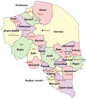
Arzuiyeh County is a county in Kerman Province in Iran. The capital of the county is Arzuiyeh. It was separated from Baft County in 2011. At the 2006 census, the county's population was 40,386, in 9,078 families. The county is subdivided into two districts (bakhsh): the Central District and Soghan District. The county has one city: Arzuiyeh.
Asrabad is a village in Meshgin-e Gharbi Rural District, in the Central District of Meshgin Shahr County, Ardabil Province, Iran. At the 2006 census, its population was 570, in 121 families.
Mahajarabad is a village in Goli Jan Rural District, in the Central District of Tonekabon County, Mazandaran Province, Iran. At the 2006 census, its population was 15, in 4 families.
Chah-e Gowd is a village in Kuh Yakhab Rural District, Dastgerdan District, Tabas County, South Khorasan Province, Iran. At the 2006 census, its population was 101, in 21 families.
Chah-e Mohammadabad Yazdani is a village in Fahraj Rural District, in the Central District of Yazd County, Yazd Province, Iran. At the 2006 census, its population was 73, in 16 families.
Sakhvid Rural District is a rural district (dehestan) in Nir District, Taft County, Yazd Province, Iran. At the 2006 census, its population was 1,747, in 565 families. The rural district has 36 villages.
Mazraeh-ye Hajjiabad is a village in Alamarvdasht Rural District, Alamarvdasht District, Lamerd County, Fars Province, Iran. At the 2006 census, its existence was noted, but its population was not reported.

