Related Research Articles

An earthquake – also called a quake, tremor, or temblor – is the shaking of the Earth's surface resulting from a sudden release of energy in the lithosphere that creates seismic waves. Earthquakes can range in intensity, from those so weak they cannot be felt, to those violent enough to propel objects and people into the air, damage critical infrastructure, and wreak destruction across entire cities. The seismic activity of an area is the frequency, type, and size of earthquakes experienced over a particular time. The seismicity at a particular location in the Earth is the average rate of seismic energy release per unit volume.

Tectonics are the processes that result in the structure and properties of the Earth's crust and its evolution through time. The field of planetary tectonics extends the concept to other planets and moons.
The moment magnitude scale is a measure of an earthquake's magnitude based on its seismic moment. Mw was defined in a 1979 paper by Thomas C. Hanks and Hiroo Kanamori. Similar to the local magnitude/Richter scale (ML ) defined by Charles Francis Richter in 1935, it uses a logarithmic scale; small earthquakes have approximately the same magnitudes on both scales. Despite the difference, news media often use the term "Richter scale" when referring to the moment magnitude scale.

The 1946 Aleutian Islands earthquake occurred near the Aleutian Islands, Alaska on April 1, 1946. The shock measured 8.6, Mt 9.3 or 7.4. It had a maximum Mercalli intensity of VI (Strong). It resulted in 165–173 casualties and over US$26 million in damage. The seafloor along the fault was elevated, triggering a Pacific-wide tsunami with multiple destructive waves at heights ranging from 45–138 ft (14–42 m). The tsunami obliterated the Scotch Cap Lighthouse on Unimak Island, Alaska among others, and killed all five lighthouse keepers. Despite the destruction to the Aleutian Island Unimak, the tsunami had almost an imperceptible effect on the Alaskan mainland.
At 20:55 PET on 25 September 2005, an earthquake measuring Mw 7.5 or ML 7.0 struck the Department of Loreto in Peru, resulting in 20 fatalities and 266 injuries, with 1,316 homes damaged or destroyed, mostly in the town of Lamas. It had a maximum perceived intensity of VI (Strong) on the Modified Mercalli Intensity Scale.

The 1977 San Juan earthquake, also known as Caucete earthquake, took place in the province of San Juan, Argentina, on 23 November at 06:26:26 AM. It measured 7.5 on the moment magnitude scale, and had a maximum perceived intensity of X (Extreme) on the Mercalli intensity scale.
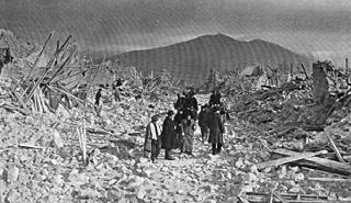
The 1855 Wairarapa earthquake occurred on 23 January at about 9.17 p.m., affecting much of the Cook Strait area of New Zealand, including Marlborough in the South Island and Wellington and the Wairarapa in the North Island. In Wellington, close to the epicentre, shaking lasted for at least 50 seconds. The moment magnitude of the earthquake has been estimated as 8.2, the most powerful recorded in New Zealand since systematic European colonisation began in 1840. This earthquake was associated with the largest directly observed movement on a strike-slip fault, maximum 18 metres (59 ft). This was later revised upward to about 20 m (66 ft) slip, with a local peak of 8 m (26 ft) vertical displacement on lidar studies. It has been suggested that the surface rupture formed by this event helped influence Charles Lyell to link earthquakes with rapid movement on faults.
The 1915 Avezzano earthquake or 1915 Fucino earthquake occurred on 13 January in central Italy at 07:52:42 local time. The shock had a moment magnitude of 6.7 and a maximum Mercalli intensity of XI (Extreme). The epicenter was located in the city of Avezzano in the Province of L'Aquila. Around 30,000 direct fatalities and $60 million in damage resulted from the earthquake.
A 6.2 magnitude earthquake occurred in Afghanistan on October 22, 2009, at 19:51:27 UTC. The maximum Mercalli intensity was V (Moderate) at Fayzabad, Badakhshan.
Shortly after midnight local time on January 20, 1981, eastern Indonesia was struck by an earthquake known as the 1981 Irian Jaya earthquake. Registering a moment magnitude of 6.7, it killed more than 300 people, damaging structures and buildings across the Irian Jaya province. Indonesia is highly active in terms of seismicity and volcanic eruptions, with a subduction zone and many faults. It is neighbored by several tectonic plates. Such earthquakes pose a significant threat to life in the area through earthquakes and also tsunamis.

The Tacoma Fault, just north of the city of Tacoma, Washington, is an active east–west striking north dipping reverse fault with approximately 35 miles (56 km) of identified surface rupture. It is believed capable of generating earthquakes of at least magnitude Mw 7, and there is evidence of such a quake approximately 1,000 years ago, possibly the same earthquake documented on the Seattle Fault 24 miles (38 km) to the north.
The 1953 Suva earthquake occurred on 14 September at 00:26 UTC near Suva, Fiji, just off the southeast shore of Viti Levu. This earthquake had an estimated magnitude of Ms 6.8 and Mw 6.4. The earthquake triggered a coral reef platform collapse and a submarine landslide that caused a tsunami. Eight people were reported killed.
The 2002 Kalehe earthquake occurred on October 24 at 06:08 UTC. This earthquake had a magnitude Mw 6.2, and the epicenter was located in Democratic Republic of the Congo, near Lake Kivu. Two people were reported dead. Building damage was reported in Goma, Lwiro, Kalehe, and Mugeri. The seismicity, volcanism, and uplift in the basin of Lake Kivu delimits the rift of a tectonic plate. Lake Kivu belongs to the western branch of the East African Rift System (EARS). The western branch is usually divided into several segments, and Lake Kivu belongs to the northern segment.
The 1989 Ungava earthquake occurred at 09:24 local time on 25 December to the north of Lac Bécard in a remote part of the Ungava Peninsula in northern Quebec. It had a magnitude of 6.3 on the surface-wave magnitude scale and 6.2–6.5 on the moment magnitude scale and a maximum felt intensity of only IV (Light) on the Mercalli intensity scale, due to its remoteness from any inhabited areas. The mainshock was preceded by a magnitude 5.1 foreshock ten hours earlier. It was the first earthquake in eastern North America known to be associated with ground rupture.

The 1983 Sea of Japan earthquake occurred on May 26, 1983, at 11:59:57 local time. It had a magnitude of 7.8 on the moment magnitude scale. It occurred in the Sea of Japan, about 100 km west of the coast of Noshiro in Akita Prefecture, Japan. Out of the 104 fatalities, all but four were killed by the resulting tsunami, which struck communities along the coast, especially Aomori and Akita Prefectures and the east coast of Noto Peninsula. Images of the tsunami hitting the fishing harbor of Wajima on Noto Peninsula were broadcast on TV. The waves exceeded 10 meters (33 ft) in some areas. Three of the fatalities were along the east coast of South Korea. The tsunami also hit Okushiri Island, the site of a more deadly tsunami 10 years later.
The 1981 Playa Azul earthquake occurred on October 24, 1981, at 21:22 local time. It was located near Playa Azul, Michoacán, Mexico. The magnitude of the earthquake was Mw 7.2, or Ms 7.3. Three deaths were reported, two from Michoacán and one from Mexico City. Some buildings were damaged in both Michoacán and Mexico City. A small tsunami was registered in Acapulco with a maximum height of 9 cm.
The 1956 Amorgos earthquake occurred at 03:11 UTC on July 9. It had a magnitude of 7.7 on the moment magnitude scale and a maximum perceived intensity of IX on the Mercalli intensity scale. The epicentre was to the south of the island of Amorgos, the easternmost island of the Cyclades in the Aegean Sea. There was significant damage on Amorgos and the neighbouring island of Santorini. It was the largest earthquake in Greece in the 20th century. It was followed 13 minutes later by a magnitude 7.2 earthquake near Santorini. It triggered a major tsunami with a maximum run-up of 30 m. The combined effects of the earthquake shaking and the tsunami caused the deaths of 53 people with a further 100 injured.

On 21 July 2017, a large earthquake measuring 6.6 on the moment magnitude scale struck right near Bodrum, a popular town of tourism in Turkey, killing 2 and injuring hundreds. Mostly referenced as the 2017 Bodrum–Kos earthquake, this earthquake generated a tsunami which was one of the largest tsunamis in the Mediterranean Sea region.
The 1963 Marj earthquake occurred on February 21 in northern Libya. The earthquake occurred at 18:14:36 local time with a moment magnitude of 5.6 and a maximum Mercalli intensity of VIII (Severe). Financial losses totaled US$5 million, with 290–375 deaths, 375–500 injuries, and 12,000 people being rendered homeless.
The Advanced National Seismic System (ANSS) is a collaboration of the United States Geological Survey (USGS) and regional, state, and academic partners that collects and analyzes data on significant earthquakes to provide near real-time information to emergency responders and officials, the news media, and the public. Such information is used to anticipate the likely severity and extent of damage, and to guide decisions on the responses needed.
References
- ↑ E. Boschi, E.; Mantovani, E.; Morelli, A., eds. (2012). "A review of the Eastern Alps – Northern Dinarides Seismotectonics". Recent Evolution and Seismicity of the Mediterranean Region. Springer. ISBN 9789401120166.
- ↑ Website for the World Stress Map Project
- ↑ NEIC Moment Tensor and Broadband Source Parameter Search
- ↑ Ambraseys, Nicolas; Melville, C.P. (1982). A History of Persian Earthquakes (PDF). Cambridge University Press. ISBN 9780521021876.
- ↑ Historical data on earthquakes and active faulting. The contribution of IRRS and IC to EC project FAUST (Contract ENV4-CT97-0428)
- ↑ Migowski, C.; Agnon A.; Bookman R.; Negendank J.F.W.; Stein M (2004). "Recurrence pattern of Holocene earthquakes along the Dead Sea transform revealed by varve-counting and radiocarbon dating of lacustrine sediments" (PDF). Earth and Planetary Science Letters. 222 (1): 301–314. Bibcode:2004E&PSL.222..301M. doi:10.1016/j.epsl.2004.02.015 . Retrieved 2009-12-29.
- ↑ Luque, L.; Lario J.; Zazo C.; Goy J.L.; Dabrio C.J.; Silva P.G. (2001). "Tsunami deposits as paleoseismic indicators: examples from the Spanish coast". Acta Geológica Hispánica. 36 (3–4): 197–211. Retrieved 2009-12-29.
- ↑ McSaveney, M.J., Graham, I.J., Begg, J.G., Beu, A.G., Hull, A.G., Kyeong, K. & Zondervan, A. 2006. Late Holocene uplift of beach ridges at Turakirae Head, south Wellington coast, New Zealand. New Zealand Journal of Geology and Geophysics abstracts, 49, 337–358.