
A summit is a point on a surface that is higher in elevation than all points immediately adjacent to it. The topographic terms acme, apex, peak, and zenith are synonymous.
The Park Range, elevation approximately 3,712 metres (12,178 ft), is a mountain range in the Rocky Mountains of northwestern Colorado in the United States. The range forms a relatively isolated part of the Continental Divide, extending north-to-south for approximately 170 kilometres (110 mi) along the boundary between Jackson (east) and Routt counties. It separates North Park in the upper basin of the North Platte River on the east from the Elk River basin in the watershed of the Yampa River the west. It rises steeply out of the Yampa River basin, forming a climatic barrier that receives much snowfall in winter. The northern end of the range lies in Wyoming and is known as the Sierra Madre Range.

Summit Lake Provincial Park is a Class C provincial park located southeast of the community of Summit Lake in the Central Kootenay region of British Columbia, Canada.

Gurnigel Pass is a high mountain pass in the canton of Bern in Switzerland.

Old Speck Mountain, also known as Old Speckle Mountain, is a mountain located in Oxford County, Maine, United States. The mountain, the fourth-highest in the state, is the northeasternmost and highest of the Mahoosuc Range, the northeasternmost part of the White Mountains. Old Speck is flanked to the southwest by Mahoosuc Arm, and faces Baldpate Mountain to the northeast across Grafton Notch.
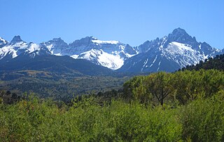
The Southern Rocky Mountains are a major subregion of the Rocky Mountains of North America located in the southeastern portion of the U.S. state of Wyoming, the central and western portions of Colorado, the northern portion of New Mexico, and extreme eastern portions of Utah. The Southern Rocky Mountains are also commonly known as the Southern Rockies, and since the highest peaks are located in the State of Colorado, they are sometimes known as the Colorado Rockies, although many important ranges and peaks rise in the other three states. The Southern Rockies include the highest mountain ranges of the Rocky Mountains and include all 30 of the highest major peaks of the Rockies.
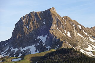
The Gantrisch is a mountain in the north-western Bernese Alps, located between the Simmental and the Aar valley in the canton of Bern. The mountain lies near Gurnigel Pass, from where it is usually climbed. A trail leads to the summit.
The Fitzsimmons Range is a small mountain range on the northwestern edge of the Garibaldi Ranges in southwestern British Columbia, Canada, located between the valleys of Cheakamus Lake (SW) and Fitzsimmons Creek (NE). Its most famous summit is Whistler Mountain, which overlooks the resort town of Whistler and is one of the two mountains forming the Whistler Blackcomb ski resort. Most of the range is within Garibaldi Provincial Park, while its northeastern extremity is part of the resort municipality, and of the lands associated with the ski resort operation. Other summits in the range include Oboe Summit, Piccolo Summit and Flute Summit, which are hillocks along the ridge running southeast from Whistler Mountain and were named in association with the renaming of Whistler. Beyond them is Singing Pass and Mount Fitzsimmons 2603 m (8540 ft) which is at the opposite end of the range from Whistler Mountain and the location of Fitzsimmons Glacier, which is the source of Fitzsimmons Creek.
Meridian Peak is a mountain summit in the Gore Range of the Rocky Mountains of North America. The 12,432-foot (3,789 m) peak is located in the Eagles Nest Wilderness, 9.0 miles (14.5 km) north by west of the Town of Vail, Colorado, United States, on the drainage divide separating White River National Forest and Eagle County from Arapaho National Forest and Summit County.

Humpy Peak is a peak located in the Uinta Mountain Range in northern Utah. It is approximately 27.56 miles (44 km) south of Evanston, Wyoming and 21.29 miles (34 km) east of Coalville, Utah. The summit has an elevation of 10,875 feet (3,315 m).

Static Peak is a mountain peak in the U.S. state of Colorado, within State Forest State Park and part of the Never Summer Mountain Range. It is located in a chain of peaks and lies between Nokhu Crags to the north and Mount Richthofen to the south. To the east lie the shallow basins of Snow Lake and to the west the mountain descends directly into the deep waters of Lake Agnes.

Winfield Peak is a mountain summit of the Collegiate Peaks in the Sawatch Range of the Rocky Mountains of North America. The 13,084-foot (3,988 m) summit is located in Chaffee County, Colorado, U.S., two miles north of the ghost town of Winfield.
Fairchild Mountain is a high mountain summit in the Mummy Range of the Rocky Mountains of North America. The 13,508-foot (4,117 m) thirteener is located in the Rocky Mountain National Park Wilderness, 9.6 miles (15.5 km) northwest of the Town of Estes Park in Larimer County, Colorado, United States.

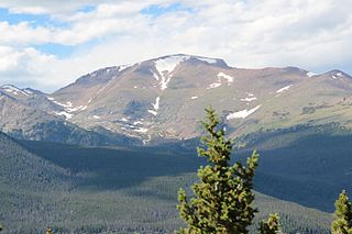
Mount Chiquita is a mountain summit in the Mummy Range of the Rocky Mountains of North America. The 13,075-foot (3,985 m) thirteener is located in Rocky Mountain National Park, 9.8 miles (15.7 km) northwest by west of the Town of Estes Park in Larimer County, Colorado, United States.

Grizzly Peak is a high mountain summit in the Front Range of the Rocky Mountains of North America. Also known as Grizzly Peak D, the 13,433-foot (4,094 m) thirteener is located in Arapaho National Forest, 2.1 miles (3.4 km) southeast by east of Loveland Pass, Colorado, United States, on the Continental Divide between Clear Creek and Summit counties. Its proximate parent peak is Torreys Peak.

Mount Parnassus is a high mountain summit in the Front Range of the Rocky Mountains of North America. The 13,580-foot (4,139 m) thirteener is located in Arapaho National Forest, 5.4 miles (8.7 km) west-northwest of the Town of Silver Plume in Clear Creek County, Colorado, United States.

The Pfyffe is a mountain of the Bernese Alpine foothills located between the municipalities of Guggisberg and Rüschegg in the canton of Bern. It is part of the wooded range north of the Gurnigel Pass, which culminates at the Selibüel. On the southern slopes of the mountain lies the small resort of Ottenleuebad.

The Belknap Mountains are a small mountain range in the Lakes Region of New Hampshire in the United States. The range lies in the towns of Gilford, Gilmanton, and Alton in Belknap County. The highest peak, Belknap Mountain, with an elevation of 2,382 feet (726 m) above sea level, is the highest point in Belknap County. Belknap Mountain State Forest covers the central part of the range, including the summit and slopes of Belknap Mountain.

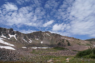
The Anthracite Range is a mountain range in the West Elk Mountains, a sub-range of the Rocky Mountains of North America. The range is located in Gunnison County of western Colorado and lies within the West Elk Wilderness of the Gunnison National Forest. The Anthracite Range is one of several prominent laccoliths found in the West Elk Mountains.
