
The Bangka Belitung Islands is a province of Indonesia. Situated off the southeastern coast of Sumatra, the province comprises two main land masses — Bangka and Belitung — and numerous smaller islands. Bangka Belitung is bordered by the Bangka Strait to the west, the Natuna Sea to the north, the Java Sea is to the south and the Karimata Strait to the east. The province's capital and largest city is Pangkalpinang. The province shares maritime borders with South Sumatra to the west, Riau Islands to the north, Banten, the Special Capital Region of Jakarta, West Java, and Central Java to the south, and West Kalimantan to the east. Bangka Belitung covers a land area of 16,690.54 km2 (6,444.25 sq mi) and had a population of 1,455,678 according to the 2020 census; the official estimate as at mid 2022 was 1,494,621.

The Riau Islands is a province of Indonesia - not to be confused with neighbouring Riau Province from which the islands were separated in 2002. The capital of the province is Tanjung Pinang and the largest city is Batam. It shares a maritime border with Riau and Jambi to the east, Bangka Belitung Islands to the south, Singapore to the northeast, Malaysia and West Kalimantan to the west, and Vietnam and Cambodia to the north. It comprises a total of 1,796 islands scattered between Sumatra, Malay Peninsula, and Borneo including the Riau Archipelago. Situated on one of the world's busiest shipping lanes along the Malacca Strait and the Natuna Sea, the province shares water borders with neighboring countries such as Singapore, Malaysia, and Brunei. The Riau Islands also have relatively large potential mineral resources and energy, as well as marine resources.

Natuna Regency is an islands regency located in the northernmost part of the Province of Riau Islands, Indonesia. It contains at least 154 islands, of which 127 of them are reported as uninhabited. This archipelago, with a land area of 1,978.31 km2 out of a total area of 264,198.37 km2 area, contains 15 districts, including the island district of Pulau Laut, Bunguran/Greater Natuna Island, the island district of Pulau Tiga, the island district of Midai, the island district of Subi, and the island district of Serasan.
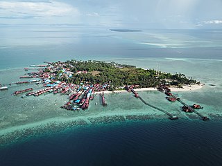
Belitung is an island on the east coast of Sumatra, Indonesia in the Java Sea. It covers 4,800.6 km2 (1,853.5 sq mi), and had a population of 309,097 at the 2020 Census. Administratively, it forms two regencies within the province of Bangka-Belitung Islands. The island is known for its pepper and for its tin. It was in the possession of the United Kingdom from 1812 until Britain ceded control of the island to the Netherlands in the Anglo-Dutch Treaty of 1824. Its main town is Tanjung Pandan. The United Nations Educational, Scientific and Cultural Organization has declared 17 tourist attractions in the Belitung Geopark as world geoparks.

Simeulue Regency is a regency in the Aceh special region of Indonesia. It occupies the whole island of Simeulue, 150 km off the west coast of Sumatra, with an area of 1,838.09 square kilometres. It had a population of 80,674 at the 2010 census and 92,865 at the 2020 census; the official estimate as at mid 2022 was 94,876.

The Lingga Regency is a group of islands in Indonesia, located south of Singapore, along both sides of the equator, off the eastern coast of Riau Province on Sumatra island. They are south of the populated Riau Archipelago, known for the industrial island of Batam and the tourist-frequented island of Bintan, although the Lingga Islands themselves are rarely visited due to the infrequent local transportation. The equator goes through the northern tip of Lingga Island, the main island in the archipelago.

Bulungan Regency is a regency of North Kalimantan Province in Indonesia. It covers an area of 13,181.92 km2 and had a population of 112,663 at the 2010 Census and 151,844 at the 2020 Census; the official estimate as at mid 2022 was 157,593. The administrative centre is at Tanjung Selor.

Pandeglang Regency is a regency of Banten province, Indonesia. It is mainly located on the west and south coasts of the island of Java, and is the most westerly regency on Java Island, but it also includes a number of offshore islands such as Panaitan, Deli and Tinjil. The regency has an area of 2,746.81 km2, and an population at the 2010 Census of 1,149,610, rising to 1,272,687 at the 2020 Census; the official estimate as at mid 2022 was 1,307,090. The regency seat is the town of Pandeglang.

Tanjungbalai, also colloquially written as Tanjung Balai, is a city in North Sumatra province, Indonesia, on the estuary of the Asahan River. It has an area of 60.52 square kilometers (23.37 sq mi) and the sixth largest kota (urban) population in North Sumatra with 154,445 inhabitants in the 2010 census and 176,027 at the 2020 Census; the official estimate as at mid 2022 was 179,748. The town has a ferry terminal with services to Port Klang, Malaysia, and the city-island of Singapore.

Bintan Regency is an administrative area in the Riau Islands Province of Indonesia. Bintan Regency includes all of Bintan Island and also includes many outlying islands including the Tambelan Archipelago and Badas Islands situated between Bintan and West Kalimantan.
Berau Regency is one of the seven regencies in East Kalimantan province in Indonesia. The capital is the town of Tanjung Redeb. It has an area of 36,962.37 km2 and had a population of 179,079 at the 2010 census and 248,035 at the 2020 census; the official estimate as at mid 2022 was 272,887.

West Bangka Regency is a regency (kabupaten) of Bangka Belitung Islands Province, Indonesia. It comprises the northwestern part of Bangka Island, together with a number of small islands off its coast. The regency covers an area of 2,820.61 km2 and had a population of 175,110 at the 2010 Census, rising to 204,612 at the 2020 census; the official estimate as at mid 2022 was 209,791 - comprising 108,102 males and 101,689 females. The town of Muntok is its regency seat.

East Tanjung Jabung Regency is a regency of Jambi Province, Indonesia. It is located on the island of Sumatra. The regency was created on 4 October 1999 by the division of the then Tanjung Jabung Regency into eastern and western halves. It now has an area of 5,085.71 km2 and had a population of 205,272 at the 2010 census and 229,813 at the 2020 census; the official estimate as at mid 2022 was 234,164. The capital lies at Muara Sabak.

North Kayong Regency is a regency of West Kalimantan province in Indonesia. It covers an area of 4,568.26 km2, and had a population of 95,594 at the 2010 Census and 126,571 at the 2020 Census; the official estimate as at mid 2022 was 131,104. The principal town lies in Sukadana. The nearest airport is Ketapang Airport.

Malinau Kota is a district and the regency seat of Malinau Regency in North Kalimantan province. The town is the economic center of the regency, largest town in the regency, and serves as a gateway for interior towns and villages around the Heart of Borneo especially neighbouring Krayan region in Nunukan Regency. It had a population of 27,736 in mid 2022.

On 6 March 2023, a series of landslides were triggered by continuous rain in Serasan Island of Serasan District, Natuna Regency, Riau Islands, Indonesia. Around 50 people were killed and four others are still missing while contact to the Serasan Island was entirely lost. An entire village was reportedly buried.

Serasan is a village on Serasan Island, Serasan District, Natuna Regency, Indonesia.

Serasan Island is an island in the Natuna Regency, Riau Islands, Indonesia. The island is split between two districts, the Serasan District is on the west side and Serasan Timur is on the east side. On March 6, 2023, heavy rainfall created landslides on the island, killing 15 and leaving many more missing. The island hosts the critically endangered Natuna Islands Tarsier, which is endemic to the islands and whose population is declining rapidly.
Midai is a district in the Natuna Regency, Riau Islands, Indonesia. It is located on the eastern half of Midai island and shares the island with the district of Suak Midai.


