| Settle, Kentucky | |
|---|---|
| Unincorporated community | |
 Settle, Kentucky | |
| Coordinates: 36°52′10″N86°12′52″W / 36.86944°N 86.21444°W Coordinates: 36°52′10″N86°12′52″W / 36.86944°N 86.21444°W | |
| Country | United States |
| State | Kentucky |
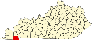
| County | Allen |
| Elevation | 712 ft (217 m) |
| Time zone | Central (CST) (UTC-6) |
| • Summer (DST) | CDT (UTC-5) |
| Area code(s) | 270 |
| GNIS feature ID | 509032 [1] |
Settle is an unincorporated community in Allen County, Kentucky, United States. Settle is located on Kentucky Route 234 10.1 miles (16.3 km) north of Scottsville. [2] Big Spring School-Oliver Farmstead, which is listed on the National Register of Historic Places, is located in Settle. [3]
Allen County is a county located in the U.S. state of Kentucky. As of the 2010 census, the population was 19,956. Its county seat is Scottsville. The county is named for Colonel John Allen, a state senator and soldier who was killed leading the 1st Regiment of Kentucky Rifleman at the Battle of Frenchtown, Michigan during the War of 1812. Allen County is a prohibition or completely dry county. It was formed in 1815 from parts of Barren and Warren counties.

Kentucky, officially the Commonwealth of Kentucky, is a state located in the east south-central region of the United States. Although styled as the "State of Kentucky" in the law creating it, (because in Kentucky's first constitution, the name state was used) Kentucky is one of four U.S. states constituted as a commonwealth. Originally a part of Virginia, in 1792 Kentucky became the 15th state to join the Union. Kentucky is the 37th most extensive and the 26th most populous of the 50 United States.
Kentucky Route 234 is a 20.033 mile (32.240 km) long north–south state highway in southern Kentucky. The southern terminus of the route is at Kentucky Route 101 six miles (10 km) north of Scottsville. The northern terminus is at U.S. Route 68 and Kentucky Route 80 in downtown Bowling Green.