
The Western Hemisphere is the half of the planet Earth that lies west of the Prime Meridian and east of the 180th meridian. The other half is called the Eastern Hemisphere. Geo-politically, the term Western Hemisphere is often used as a metonym for the Americas or the "New World", even though geographically the hemisphere also includes parts of other continents.

Taupō, sometimes written Taupo, is a town located in the central North Island of New Zealand. It is situated on the edge of Lake Taupō, which is the largest freshwater lake in New Zealand. Taupō was constituted as a borough in 1953. It has been the seat of Taupō District Council since the council was formed in 1989.

A coastal plain is flat, low-lying land adjacent to a sea coast. A fall line commonly marks the border between a coastal plain and a piedmont area. Some of the largest coastal plains are in Alaska and the southeastern United States. The Gulf Coastal Plain of North America extends northwards from the Gulf of Mexico along the Lower Mississippi River to the Ohio River, which is a distance of about 981 miles (1,579 km). The Atlantic Coastal Plain runs from the New York Bight to Florida.

The Eastern Hemisphere is the half of the planet Earth which is east of the prime meridian and west of the antimeridian. It is also used to refer to Afro-Eurasia and Australia, in contrast with the Western Hemisphere, which includes mainly North and South America. The Eastern Hemisphere may also called the "Oriental Hemisphere", and may in addition be used in a cultural or geopolitical sense as a synonym for "Old World."
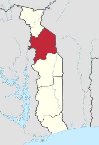
Kara Region is one of Togo's five regions. Kara is the regional capital.
Chartwell Agricultural Holdings is a rural settlement in Gauteng, South Africa. It is located in the former Region 1 and Region 5. Chartwell is mainly an agricultural suburb made up of small holdings. Chartwell AH is bisected by Cedar Avenue, which runs on the line of Sixth Road, Chartwell. This effectively divides Chartwell into North and South sections, known as Chartwell North Estates (CNE) and Chartwell Country Estates (CCE), respectively.
Victoria is a suburb of Johannesburg, South Africa. It is located in Region E of the City of Johannesburg Metropolitan Municipality. It is a small suburb located north-east of the city centre surrounded by Norwood to its north, the Houghton Estate to its west and south, while Orange Grove lies to the east.

The Kaniksu National Forest is a U.S. National Forest located in northeastern Washington, the Idaho Panhandle, and northwestern Montana. It is one of three forests that are aggregated into the Idaho Panhandle National Forests, along with the Coeur d'Alene National Forest and St. Joe National Forest. Kaniksu National Forest has a total area of 1,627,833 acres (6,587.6 km2). About 55.7% is in Idaho, 27.9% in Montana, and 16.4% in Washington.

Pisgah National Forest is a National Forest in the Appalachian Mountains of western North Carolina. It is administered by the United States Forest Service, part of the United States Department of Agriculture. The Pisgah National Forest is completely contained within the state of North Carolina. The forest is managed together with the other three North Carolina National Forests from common headquarters in Asheville, North Carolina. There are local ranger district offices located in Pisgah Forest, Mars Hill, and Nebo.
Tinnsjå is one of the largest lakes in Norway measuring about 51.38 km2 (19.84 sq mi). It is also one of the deepest lakes in Europe, reaching a depth of 460 m (1,510 ft). Tinnsjå is located in the municipalities of Tinn and Notodden in Telemark county. At its source in the west, the Måna river flows out of the lake Møsvatn and past the town of Rjukan into Tinnsjå. From the north, the river Mår flows from the lakes Mår, Gøystavatn, and Kalhovdfjorden into Tinnsjå. Tinnsjå is part of the Skien watershed, and it drains via the Tinnelva river in the south, down to the lake Heddalsvatn.
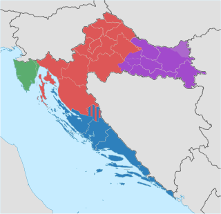
The Republic of Croatia is administratively organised into twenty counties, and is also traditionally divided into four historical and cultural regions: Croatia proper, Dalmatia, Istria, and Slavonia. These are further divided into other, smaller regions.
Baugevatnet is a lake that lies in Narvik Municipality in Nordland county, Norway. The 4.99-square-kilometre (1.93 sq mi) lake is located about 25 kilometres (16 mi) east of the village of Kjøpsvik and just 1.5 kilometres (0.93 mi) northwest of the border with Sweden. The lake Båvrojávrre lies about 3 kilometres (1.9 mi) to the southwest and the lake Langvatnet lies about the same distance to the north.
Hundålvatnet is a lake that lies in the municipality of Vefsn in Nordland county, Norway. The 7.96-square-kilometre (3.07 sq mi) lake lies in the western part of the municipality, about 12 kilometres (7.5 mi) west of the town of Mosjøen. It is located just north of the Lomsdal–Visten National Park. The lake flows into the Hundåla river which flows north into the Vefsnfjorden.

Bygdin is a lake in Vang Municipality in Innlandet county, Norway. The 40-square-kilometre (15 sq mi) is located in the southern part of the Jotunheimen mountain range. The 25-kilometre (16 mi) long, narrow mountain lake is located between the large lakes Tyin and Vinstre to the east.
Breiddalsvatnet is a lake in Skjåk Municipality in Innlandet county, Norway. The 6.9-square-kilometre (2.7 sq mi) lake lies just west of the village of Grotli. The Norwegian National Road 15 runs along the north side of the lake. The mountains Helleggi and Krosshø are located just north of the lake and the Breheimen National Park lies just south of the lake.
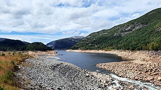
Botsvatn or Bossvatn is a lake in the municipality of Bykle in Agder county, Norway. The 14.6-kilometre (9.1 mi) long, narrow reservoir is located just to the southeast of the large lake Blåsjø and northeast of the lake Ytre Storevatnet. The lake holds water for the Brokke Hydroelectric Power Station, located in nearby Valle municipality. The water from the lake can flow out into the nearby river Otra, but only when water is released from the dam.
Funnsjøen is a lake in the municipality of Meråker in Trøndelag county, Norway. The 8-square-kilometre (3.1 sq mi) lake flows into the Funna river, a part of the Stjørdalselva river system. The lake has a hydropower dam at the southern end of the lake. There is about 64,000,000 cubic metres (84,000,000 cu yd) of water stored behind the dame in the lake.
Tolgate or Tollgate is a neighbourhood in north Chennai, India.

The Growler Mountains is a 23-mile, (37-km) long north-south trending mountain range of far western Pima County, Arizona that lies 12 miles (19 km) west of Ajo, Arizona. This desert region of southern Arizona lies in the north and central Sonoran Desert, and is one of the drier desert areas of North America.

The Risihorn is a mountain of the Bernese Alps, overlooking Bellwald in the canton of Valais. It lies south of the Setzehorn, at the southern end of the chain lying east of the Fiescher Glacier.
