
Yorkshire Wildlife Trust is a charitable non-governmental organisation, one of the UK's 46 county-based Wildlife Trusts. Its focus is nature conservation and it works to achieve a nature-rich Yorkshire with healthy and resilient ecosystems that support both Yorkshire's wildlife and its people.

The Greater Accra Region has the smallest area of Ghana's 16 administrative regions, occupying a total land surface of 3,245 square kilometres. This is 1.4 per cent of the total land area of Ghana. It is the most populated region, with a population of 5,455,692 in 2021, accounting for 17.7 per cent of Ghana's total population.
Articles related to Ghana include:

The Ankasa Conservation Area is located in southwestern Ghana, approximately 365 kilometers west of Accra, near the border with Côte d'Ivoire. It encompasses the Nini Suhien National Park to the north and the Ankasa Forest Reserve to the south.
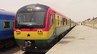
Ghana Railway Company Limited is the company that operates the railways of Ghana. The Ghana Railway Company Limited is a public-sector body with responsibility for the efficient management of the national rail system so as to enhance the smooth movement of goods and passengers.

The railway stations in Ghana serve a rail network concentrated in the south of the country.
Pokuase, also spelled Pokoasi, is a suburb of Accra, the capital city of Ghana and spans the area from Pokuase, leading off the Accra-Kumasi motorway on the right coming from Accra central; and leading off the motorway at Pokuase Junction and rising to ‘Okai Kwei Hill’, on the left coming from town. It is a mixture of lively retail shopping areas, with local stores, bars or 'drinking spots', bus/taxi stations, and a market. It also has many hotels, guest houses and rental apartments- such as the eco-chic Legassi Gardens Apartments-, and 'high-end' developing residential estates, such as Ofankor Hills Estates and Franko Estates, amongst many others; as well as the long-established executive gated community of ACP Estates.; and HFS Estates which borders the erstwhile Gua Koo Sacred Grove in Pokuase.
The Central Zambezian miombo woodlands ecoregion spans southern central Africa. Miombo woodland is the predominant plant community. It is one of the largest ecoregions on the continent, and home to a great variety of wildlife, including many large mammals.

The railway system in Ghana has historically been confined to the plains south of the barrier range of mountains north of the city of Kumasi. However, the 1,067 mm narrow gauge railway, totalling 1,300 kilometres, is undergoing major rehabilitation and inroads to the interior are now being made. In Ghana, most of the lines are single tracked, and in 1997 it was estimated that 32 kilometres were double tracked.

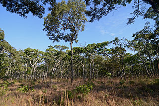
Mole National Park, one of Ghana's seven national parks, is the country's largest wildlife refuge. The park is located in the Savannah region of Ghana on savanna and riparian ecosystems at an elevation of 50 m, with a sharp escarpment forming the southern boundary of the park. The Park is 24 km from Damongo, the district capital, 146 km south east of Tamale, the Regional capital. The park is 700 km from Accra and 430 km from Kumasi. The park's entrance is reached through the nearby town of Larabanga. It covers an area of about 4,577 square kilometers of fairly undisturbed Guinea savannah in the northern part of Ghana. The Levi and Mole Rivers are ephemeral rivers flowing through the park, leaving behind only drinking holes during the long dry season. This area of Ghana receives over 10 mm per year of rainfall. A long-term study has been done on Mole National Park to understand the impact of human hunters on the animals in the preserve.
Bia National Park is a national park in the Bia district in the Western Region of Ghana. It is also a biosphere reserve with a 563 square kilometer resource reserve. It has some of Ghana's last remnants of relatively untouched forest complete with its full diversity of wildlife. Some of the tallest trees left in West Africa are found in this national park. It constitutes a twin conservation area called the Bia National Park and the Bia Resource Reserve.
The Ibanda-Kyerwa National Park, previously Ibanda Game Reserve, is a national park in Tanzania. Originally established in 1974, it was designated a national park in 2019. The national park is located in Kagera Region and has an area of 200 square kilometres (77 sq mi). The park is rich in wildlife attractions and sunrise and sunset are easily seen. Animals found in this national park include hippos, antelopes, Thomson gazelles, impalas, elands, and baboons. The park can be reached by flight from Dar es Salaam Airport to Bukoba Airport and then by road from Bukoba town to the park.
Dodowa is a town located in the Greater Accra Region of Ghana, it is the district capital of Dangme West district, now Shai Osudoku District.

Ruma National Park is the only terrestrial park in Kenya's Nyanza Province. Dubbed the "Last Retreat of the Roan Antelope", the park protects the only indigenous population of rare roan antelopes within Kenya. At present, the population is on the verge of extinction with individual populations numbering approximately 40. The park was established in 1966 as Lambwe Valley Game Reserve. It was later renamed “Ruma” after one of Kenya's most powerful wizard, the much feared Gor Mahia who lived around the park. The park is located in the vast Lambwe Valley.

Shai Hills Resource Reserve is a resource reserve located in Doryumu in the Shai Osudoku District all in the Greater Accra Region of southern Ghana. It lies along the Tema-Akosombo Highway some 57 km from Accra.
Tourism in Ghana is regulated by the Ministry of Tourism, Arts & Culture. This ministry is responsible for the development and promotion of tourism related activities in Ghana.
The Ghana Wildlife Society is a conservationist NGO seeking to support Ghana's diverse wildlife to help provide both a "better environment" and an "improved quality of life for all people." It is BirdLife International's partner in Ghana. The society was formed in the early 1970s but suffered from a hiatus in its activities. It was restarted in 1991 through a "Save the Seashore Birds Project - Ghana (SSPC-G)". This project ended in June 1994 and the Society took over the work of that project.

Shai Osudoku District is one of the twenty-nine districts in Greater Accra Region, Ghana. Originally it was formerly part of the then-larger Dangme West District in 1988, which was created from the former Dangme District Council, until the southern part of the district was split off to create Ningo-Prampram District on 28 June 2012; thus the remaining part has been renamed as Shai-Osudoku District. The Shai Osudoku District Assembly is located in the eastern part of Greater Accra Region and has Dodowa as its capital town, which is about 39 km from the regional capital, Accra.
Issa is the capital of the Daffiama Bussie Issa district in the Upper West Region of Ghana. It became the capital after the district was established in 2012.
The Gbele Resource Centre or Gbele Game Production Reserve is one of the lesser known game reserves in Ghana. The reserve is the fourth largest in Ghana.

