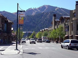
Ketchum is a city in Blaine County, Idaho, United States. Located in the central part of the state, the population was 3,555 at the 2020 census, up from 2,689 in 2010. Located in the Wood River Valley, Ketchum is adjacent to Sun Valley and the communities share many resources: both sit in the same valley beneath Bald Mountain, with its skiing. The city also draws tourists to its fishing, hiking, trail riding, tennis, shopping, art galleries, and more. The airport for Ketchum, Friedman Memorial Airport, is approximately 15 miles (24 km) south in Hailey.
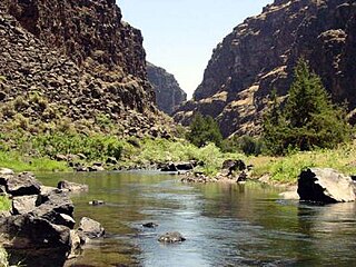
The Bruneau River is a 153-mile-long (246 km) tributary of the Snake River, in the U.S. states of Idaho and Nevada. It runs through a narrow canyon cut into ancient lava flows in southwestern Idaho. The Bruneau Canyon, which is up to 1,200 feet (370 m) deep and 40 miles (64 km) long, features rapids and hot springs, making it a popular whitewater trip.
The Shoshone or Shoshoni are a Native American tribe with four large cultural/linguistic divisions:

The Indigenous peoples of the Great Basin are Native Americans of the northern Great Basin, Snake River Plain, and upper Colorado River basin. The "Great Basin" is a cultural classification of indigenous peoples of the Americas and a cultural region located between the Rocky Mountains and the Sierra Nevada, in what is now Nevada, and parts of Oregon, California, Idaho, Wyoming, and Utah. The Great Basin region at the time of European contact was ~400,000 sq mi (1,000,000 km2). There is very little precipitation in the Great Basin area which affects the lifestyles and cultures of the inhabitants.

The Selway–Bitterroot Wilderness is a protected wilderness area in the states of Idaho and Montana, in the northwestern United States. At 1.3 million acres (5,300 km²), it is one of the largest designated wilderness areas in the United States.

Bitterroot National Forest comprises 1.587 million acres (6,423 km2) in west-central Montana and eastern Idaho of the United States. It is located primarily in Ravalli County, Montana, but also has acreage in Idaho County, Idaho (29.24%), and Missoula County, Montana (0.49%).

The Hells Canyon Wilderness is a wilderness area in the western United States, in Idaho and Oregon. Created 49 years ago in 1975, the Wilderness is managed by both the U.S. Bureau of Land Management and the U.S. Forest Service and contains some of the most spectacular sections of the Snake River as it winds its way through Hells Canyon, North America's deepest river gorge and one of the deepest gorges on Earth. The Oregon Wilderness Act of 1984 added additional acreage and currently the area protects a total area of 217,927 acres (88,192 ha). It lies entirely within the Hells Canyon National Recreation Area except for a small 946-acre (383 ha) plot in southeastern Wallowa County, Oregon which is administered by the Bureau of Land Management. The area that is administered by the Forest Service consists of portions of the Wallowa, Nez Perce, Payette, and Whitman National Forests.

Sawtooth National Forest is a National Forest that covers 2,110,408 acres in the U.S. states of Idaho and Utah. Managed by the U.S. Forest Service in the U.S. Department of Agriculture, it was originally named the Sawtooth Forest Reserve in a proclamation issued by President Theodore Roosevelt on May 29, 1905. On August 22, 1972, a portion of the forest was designated as the Sawtooth National Recreation Area (SNRA), which includes the Sawtooth, Cecil D. Andrus–White Clouds, and Hemingway–Boulders wilderness areas. The forest is managed as four units: the SNRA and the Fairfield, Ketchum, and Minidoka Ranger Districts.

Central Idaho is a geographical term for the region located northeast of Boise and southeast of Lewiston in the U.S. state of Idaho. It is dominated by federal lands administered by the United States Forest Service and the Bureau of Land Management. Idaho's tallest mountain, Borah Peak, is located in this region. A large part of the Sawtooth National Recreation Area is within Central Idaho.

The Seven Devils Mountains are notable peaks in the western United States, located in west central Idaho in the Hells Canyon Wilderness. They are above the east bank of the Snake River, which forms the Idaho-Oregon border.
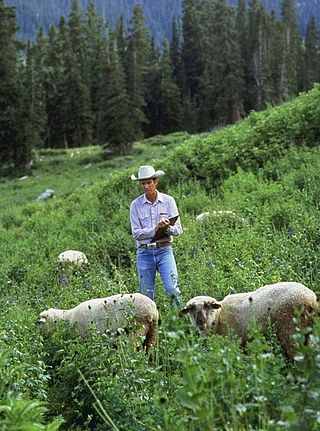
The U.S. Sheep Experiment Station (USSES) is an agricultural experiment station focusing on domestic sheep which is run by the United States Department of Agriculture's Agricultural Research Service. Its stated mission is "...to develop integrated methods for increasing production efficiency of sheep and to simultaneously improve the sustainability of rangeland ecosystems".
The Panama is a breed of domestic sheep native to the United States. Though its name is identical to the country of Panama, the breed was in fact named for the Panama–Pacific International Exposition where it was shown early on in its history.

The Tukudeka or Mountain Sheepeaters are a band of Shoshone within the Eastern Shoshone and the Northern Shoshone. Before the reservation era, they traditionally lived in the central Sawtooth Range of Idaho and the mountains of what is now northwest Wyoming. Bands were very fluid and nomadic, and they often interacted with and intermarried other bands of Shoshone. Today the Tukudeka are enrolled in the federally recognized Shoshone-Bannock Tribes of the Fort Hall Reservation of Idaho and the Eastern Shoshone of the Wind River Indian Reservation in Wyoming.

The Centennial Mountains are the southernmost sub-range of the Bitterroot Range in the U.S. states of Idaho and Montana. The Centennial Mountains include the Western and Eastern Centennial Mountains. The range extends east from Monida Pass along the Continental Divide to Henrys Fork 48 km (30 mi) NNW of Ashton, Idaho; bounded on the west by Beaver Creek, on the north by Centennial Valley and Henrys Lake Mountains, on the east by Henrys Lake Flat, and on the south by Shotgun Valley and the Snake River Plain. The highest peak in the range is Mount Jefferson.
Craig Mountain Wildlife Management Area at 115,000 acres (470 km2) is an Idaho wildlife management area in Nez Perce County along the Snake River in southern Lewiston. The WMA is cooperatively managed by the Idaho Department of Fish and Game and the Bureau of Land Management.

The Lemhi Range is a mountain range in the U.S. state of Idaho, spanning the eastern part of the state between the Lost River Range and the Beaverhead Mountains. The highest point in the range is Diamond Peak at 12,202 feet (3,719 m), the third highest peak in Idaho. The range is located within Salmon-Challis and Caribou-Targhee National Forests.
White Cloud Peak 10, also known as WCP 10, at 11,102 feet (3,384 m) above sea level is an unofficially named peak in the White Cloud Mountains of Idaho. The peak is located in Sawtooth National Recreation Area in Custer County 0.53 mi (0.85 km) south of Calkins Peak, its line parent. It is the 89th highest peak in Idaho. Sheep Lake is directly south of the peak, and Tin Cup Lake is directly north of the peak.

Calkins Peak, is a peak also known as Calkens, O'Calkens Peak, Caulkens Peak, and O'Caulkens Peak. At an elevation of 11,487 feet (3,501 m) above sea level it is the second highest peak in the White Cloud Mountains of Idaho. The peak is located in Sawtooth National Recreation Area in Custer County about 5.75 mi (9.25 km) north-northwest of Castle Peak, its line parent. It is the 46th highest peak in Idaho, and it is located about 0.5 mi (0.80 km) north-northeast of White Cloud Peak 9 and 1 mi (1.6 km) north-northwest of D. O. Lee Peak. Calkins Peak is directly north of Slide Lake, northwest of Sheep Lake, and southwest of Tin Cup Lake. Calkins Peak is named for Stephen Calkins (1842–1922), a prospector who established lode claims in the area.
Sheep Hills most often refers to:


