"},"population_note":{"wt":""},"population_total":{"wt":"46409"},"population_density_km2":{"wt":""},"population_density_sq_mi":{"wt":""},"population_metro":{"wt":""},"population_density_metro_km2":{"wt":""},"population_density_metro_sq_mi":{"wt":""},"population_urban":{"wt":""},"population_density_urban_km2":{"wt":""},"population_density_urban_sq_mi":{"wt":""},"timezone":{"wt":"East"},"utc_offset":{"wt":"+6"},"latd":{"wt":""},"latm":{"wt":""},"lats":{"wt":""},"latNS":{"wt":""},"longd":{"wt":""},"longm":{"wt":""},"longs":{"wt":""},"longEW":{"wt":""},"elevation_footnotes":{"wt":""},"elevation_m":{"wt":""},"elevation_ft":{"wt":""},"website":{"wt":""},"footnotes":{"wt":""}},"i":0}}]}" id="mwAg">District in East Kazakhstan Region, Kazakhstan
Shemonaikha | |
---|---|
District | |
Шемонаиха ауданы | |
![]() | |
Country | ![]() |
Region | East Kazakhstan Region |
Administrative center | Shemonaikha |
Founded | 1928 |
Government | |
• Akim | Akulov Grigory Iosifovich [1] |
Area | |
• Total | 4,000 km2 (2,000 sq mi) |
Population (2013) [2] | |
• Total | 46,409 |
Time zone | UTC+6 (East) |
Shemonaikha District | |||
---|---|---|---|
Traditional Chinese | 舍莫奈哈區 | ||
Simplified Chinese | 舍莫奈哈区 | ||
|
Shemonaikha (Kazakh :Шемонаихаауданы,Şemonaiha audany) is a district of East Kazakhstan Region in eastern Kazakhstan. The administrative center of the district is the town of Shemonaikha. [3] Population:46,409 (2013 estimate); [2] 49,202 (2009 Census results); [4] 57,815 (1999 Census results). [4]
Located in the north of East Kazakhstan Region. It borders in the east with Glubokovsky,in the west - with Borodulikha,in the south - with Ulansky districts of East Kazakhstan region,in the north - with Altai Territory Russian Federation. [5]
Shemonaikha district was formed on January 17,1928 from Shemonaevskaya,parts of Kalininskaya,Ubinskaya volosts Semipalatinsk district and part of Krasnooktyabrskaya volost Ust-Kamenogorsk district with the center in the village of Shemonaikha. On June 11,1959,the Arable Council,Verkhubinsky,Vydrikinsky and Bolsherechensky village councils of the abolished Verkh-Ubinsky district were attached to the Shemonaikha district. [6]
Kerbulak District is a district of Almaty Region in Kazakhstan. The administrative center of the district is the settlement of Saryozek. Population:49,633;47,992;53,522.
Sarkand District or Sarkant District is a district of Almaty Region in Kazakhstan. The administrative center of the district is the town of Sarkand. Population:40,683;41,016;47,808.
Kargaly is a district of Aktobe Region in Kazakhstan. The administrative center of the district is the settlement of Badamsha. Population:16,741;16,781;19,172.
Kobda is a district of Aktobe Region in Kazakhstan. The administrative center of the district is the aul of Kobda. Population:19,453;19,591;27,636.
Khromtau is a district of Aktobe Region in Kazakhstan. The administrative center of the district is the town of Khromtau. Population:41,334;39,748;43,814.
Martuk is a district of Aktobe Region in Kazakhstan. The administrative center of the district is the selo of Martuk. Population:29,647;29,843;31,084.
Shalkar is a district of Aktobe Region in Kazakhstan. The administrative center of the district is the town of Shalkar. Population:45,513;44,187;46,697.
Kurchum is a district of East Kazakhstan Region in eastern Kazakhstan. The administrative center of the district is the selo of Kurshim. Population:29,476;31,967;45,057.
Zaysan is a district of East Kazakhstan Region in eastern Kazakhstan. The administrative center of the district is the town of Zaysan. Population:37,924;34,593;39,556.
Zharma is a district of Abai Region in eastern Kazakhstan. The administrative center of the district is the selo of Qalbatau. Population:43,176;44,831;60,247.
Kyzylzhar is a district of North Kazakhstan Region in northern Kazakhstan. The administrative center of the district is the selo of Beskol. Population:44,681;44,454;50,258.
Shet District is a district of Karaganda Region in central Kazakhstan. The administrative center of the district is the selo of Aksu-Ayuly. Population:44,971;45,715;54,341.
Karabalyk is a district of Kostanay Region in eastern Kazakhstan. The administrative center of the district is the urban-type settlement of Karabalyk. Population:29,594;31,399;43,145.
Uzunkol is a district of Kostanay Region in northern Kazakhstan. The administrative center of the district is the selo of Uzunkol. Population:23,881;25,480;31,332.
Zhetikara is a district of Kostanay Region in northern Kazakhstan. The administrative center of the district is the town of Zhetikara. Population:50,805;50,441;56,497.
Akzhaik is a district of West Kazakhstan Region in western Kazakhstan. The administrative center of the district is the selo of Chapaev. Population:41,067;41,777;49,364.
Shyngyrlau is a district of West Kazakhstan Region in western Kazakhstan. The administrative center of the district is the selo of Shyngyrlau. Population:15,304;16,116;21,799.
Zhanybek is a district of West Kazakhstan Region in western Kazakhstan. The administrative center of the district is the selo of Zhanybek. Population:16,639;16,896;19,511.
Bokey Orda is a district of West Kazakhstan Region in western Kazakhstan. The administrative center of the district is the selo of Saykyn. Population:16,016;16,668;19,507.
Bayterek,previously Zelenov is a district of West Kazakhstan Region in western Kazakhstan. The administrative center of the district is the selo of Peremyotnoye. Population:54,831;55,420;56,611.
Capital: Oskemen | ||
Districts | ||
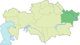
Cities of regional subordination | ||
Major cities | ||
Nuclear test sites |
Coordinates: 50°37′46″N81°54′17″E / 50.62944°N 81.90472°E