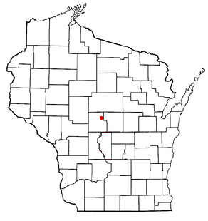
Sherry (community), Wisconsin

Last updated

Sherry, Wisconsin
USA Wisconsin location map.svg
Red pog.svg
Sherry, Wisconsin
Usa edcp location map.svg
Red pog.svg
Sherry, Wisconsin
Coordinates: 44°35′03″N89°54′56″W / 44.58417°N 89.91556°W / 44.58417; -89.91556 Coordinates: 44°35′03″N89°54′56″W / 44.58417°N 89.91556°W / 44.58417; -89.91556
Country Flag of the United States.svg  United States
State Flag of Wisconsin.svg  Wisconsin
County Wood
Elevation
350 m (1,148 ft)
Time zone UTC-6 (Central (CST))
  Summer (DST) UTC-5 (CDT)
Area code(s) 715 & 534
GNIS feature ID1574037 [1]

Sherry is an unincorporated community located in the town of Sherry, Wood County, Wisconsin, United States. Sherry is located at the junction of County Highways N and F 3.5 miles (5.6 km) west-southwest of Milladore. [2]

Unincorporated area Region of land not governed by own local government

In law, an unincorporated area is a region of land that is not governed by a local municipal corporation; similarly an unincorporated community is a settlement that is not governed by its own local municipal corporation, but rather is administered as part of larger administrative divisions, such as a township, parish, borough, county, city, canton, state, province or country. Occasionally, municipalities dissolve or disincorporate, which may happen if they become fiscally insolvent, and services become the responsibility of a higher administration. Widespread unincorporated communities and areas are a distinguishing feature of the United States and Canada. In most other countries of the world, there are either no unincorporated areas at all, or these are very rare; typically remote, outlying, sparsely populated or uninhabited areas.

Sherry, Wisconsin Town in Wisconsin, United States

Sherry is a town in Wood County, Wisconsin, United States. The population was 809 at the 2000 census. The unincorporated community of Sherry is located in the town.

Wood County, Wisconsin U.S. county in Wisconsin

Wood County is a county located in the U.S. state of Wisconsin. As of the 2010 census, the population was 74,749. Its county seat is Wisconsin Rapids. The county is named after Joseph Wood, a member of the Wisconsin State Assembly.

Contents

History

Sherry was platted in 1899, and named after Henry Sherry, proprietor of a local sawmill, and the owner of the Sherry Lumber Company which began operations around 1880. [3] [4]

Plat map showing a piece of land, drawn to scale, with details such as nearby properties, boundaries, land size, flood zones, the surrounding neighborhood, easements, and monuments

In the United States, a plat is a map, drawn to scale, showing the divisions of a piece of land. United States General Land Office surveyors drafted township plats of Public Lands Surveys to show the distance and bearing between section corners, sometimes including topographic or vegetation information. City, town or village plats show subdivisions into blocks with streets and alleys. Further refinement often splits blocks into individual lots, usually for the purpose of selling the described lots; this has become known as subdivision.

Sawmill facility where logs are cut into timber

A sawmill or lumber mill is a facility where logs are cut into lumber. Modern saw mills use a motorized saw to cut logs lengthwise to make long pieces, and crosswise to length depending on standard or custom sizes. The "portable" saw mill is iconic and of simple operation—the logs lay flat on a steel bed and the motorized saw cuts the log horizontally along the length of the bed, by the operator manually pushing the saw. The most basic kind of saw mill consists of a chainsaw and a customized jig, with similar horizontal operation.

A post office called Sherry was established in 1884, and remained in operation until 1968. [5]

Related Research Articles

Blenker, Wisconsin Unincorporated community in Wisconsin, United States

Blenker is an unincorporated community in the town of Milladore, in Wood County, Wisconsin, United States.

Dexterville, Wisconsin Unincorporated community in Wisconsin, United States

Dexterville is an unincorporated community in the town of Dexter, Wood County, Wisconsin, United States. It is located at the intersection of Wisconsin Highway 80 and Wisconsin Highway 54.

Marshland, Wisconsin Unincorporated community in Wisconsin, United States

Marshland is an unincorporated community located in the town of Buffalo, in Buffalo County, Wisconsin, United States. Marshland is located on Wisconsin Highway 35 and Wisconsin Highway 54 8.5 miles (13.7 km) east-southeast of Fountain City.

Montana (community), Wisconsin Unincorporated community in Wisconsin, United States

Montana is an unincorporated community located in the town of Montana, in Buffalo County, Wisconsin, United States. Montana is located at the junction of County Highways C and U 11.5 miles (18.5 km) northeast of Cochrane.

Hawthorne (community), Wisconsin Unincorporated community in Wisconsin, United States

Hawthorne is an unincorporated community, located in the town of Hawthorne, Douglas County, Wisconsin, United States.

Whitcomb, Wisconsin Unincorporated community in Wisconsin, United States

Whitcomb is an unincorporated community located in the town of Wittenberg, Shawano County, Wisconsin, United States. Whitcomb is located on Wisconsin Highway 153 near its junction with U.S. Route 45, 4 miles (6.4 km) southeast of the village of Wittenberg.

Big Foot Prairie, Illinois and Wisconsin Unincorporated community in the United States

Big Foot Prairie is an unincorporated community in both McHenry County, Illinois and Walworth County, Wisconsin, United States. The Illinois portion of the community, which is larger, is located in Chemung Township, while the Wisconsin portion is located in the Town of Walworth. Big Foot Prairie is located on U.S. Route 14, 5 miles (8.0 km) north of Harvard.

Basswood, Wisconsin Unincorporated community in Wisconsin, United States

Basswood is an unincorporated community located in the town of Eagle, Richland County, Wisconsin, United States. Basswood is located on County Highway E 7.5 miles (12.1 km) southwest of Richland Center. The area’s original post office, which opened in August 1869, was named Lucas in honor of farmer James Lucas. Later that year, the name was changed to Bass Wood and was changed again to Basswood in 1892.
Bakerville, Wisconsin Unincorporated community in Wisconsin, United States

Bakerville is an unincorporated community located in the town of Lincoln, Wood County, Wisconsin, United States. Bakerville is located at the junction of County Highways B and BB 3.5 miles (5.6 km) southwest of Marshfield.

Kellner, Wisconsin Unincorporated community in Wisconsin, United States

Kellner is an unincorporated community located in Portage and Wood counties, Wisconsin, United States. The Portage County portion of Kellner is located in the town of Grant, while the Wood County portion is located in the town of Grand Rapids. Kellner is located at the junction of County Highways U and WW 5.5 miles (8.9 km) east-southeast of Wisconsin Rapids.

Price, Jackson County, Wisconsin Unincorporated community in Wisconsin, United States

Price is an unincorporated community located in the town of Garfield, Jackson County, Wisconsin, United States. Price is located along U.S. Route 10 5 miles (8.0 km) west-southwest of Fairchild.

Kickapoo Center, Wisconsin Unincorporated community in Wisconsin, United States

Kickapoo Center is an unincorporated community located in the town of Kickapoo, Vernon County, Wisconsin, United States. Kickapoo Center is located on Wisconsin Highway 131 near the Kickapoo River, 3 miles (4.8 km) south-southwest of Viola.

London, Wisconsin Unincorporated community in Wisconsin, United States

London is an unincorporated community located in the counties of Dane and Jefferson in the U.S. state of Wisconsin. The Dane County portion of London is in the town of Deerfield, while the Jefferson County portion is in the town of Lake Mills. London is on Wisconsin Highway 134, 3 miles (4.8 km) north of Cambridge.

Angus, Wisconsin Unincorporated community in Wisconsin, United States

Angus is an unincorporated community in the town of Cedar Lake, Barron County, Wisconsin, United States. Angus is located on Wisconsin Highway 48 2.5 miles (4.0 km) southwest of Birchwood.

Veedum, Wisconsin Unincorporated community in Wisconsin, United States

Veedum is an unincorporated community located in the town of Dexter, Wood County, Wisconsin, United States.

Mosling, Wisconsin Unincorporated community in Wisconsin, United States

Mosling is an unincorporated community located in the towns of Gillett and Underhill, Oconto County, Wisconsin, United States. Mosling is located on County Highway P 3.4 miles (5.5 km) west-southwest of Gillett.

Cranmoor (community), Wisconsin Unincorporated community in Wisconsin, United States

Cranmoor is an unincorporated community located in the town of Cranmoor, Wood County, Wisconsin, United States.

Black Hawk, Wisconsin Unincorporated community in Wisconsin, United States

Black Hawk is an unincorporated community in the town of Troy, Sauk County, Wisconsin, United States. Black Hawk is located on County Highway C 5.9 miles (9.5 km) east of Plain.

Cobban, Wisconsin Unincorporated community in Wisconsin, United States

Cobban is an unincorporated community located in the town of Arthur, Chippewa County, Wisconsin, United States. Cobban is located on the east bank of the Chippewa River at the junction of County Highways K and TT, 5.2 miles (8.4 km) south-southwest of Cornell.

References

  1. U.S. Geological Survey Geographic Names Information System: Sherry (community), Wisconsin
  2. Wood County (PDF) (Map). Wisconsin Department of Transportation. Archived from the original (pdf) on May 16, 2008. Retrieved July 17, 2011.
  3. Rudolph, Robert S. (1970). Wood County Place Names (PDF). The University of Wisconsin Press. p. 76.
  4. "Our History | Town of Sherry, Wood County, Wisconsin". townofsherry.com. Retrieved November 10, 2019.
  5. "Post Offices". Jim Forte Postal History. Retrieved March 27, 2018.