
The Glasgow and South Western Railway (G&SWR) was a railway company in Scotland. It served a triangular area of south-west Scotland between Glasgow, Stranraer and Carlisle. It was formed on 28 October 1850 by the merger of two earlier railways, the Glasgow, Paisley, Kilmarnock and Ayr Railway and the Glasgow, Dumfries and Carlisle Railway. Already established in Ayrshire, it consolidated its position there and extended southwards, eventually reaching Stranraer. Its main business was mineral traffic, especially coal, and passengers, but its more southerly territory was very thinly populated and local traffic, passenger and goods, was limited, while operationally parts of its network were difficult.
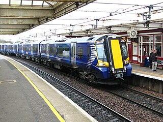
The Ayrshire Coast Line is one of the lines within the Strathclyde suburban rail network in Scotland. It has 26 stations and connects the Ayrshire coast to Glasgow. There are three branches, to Largs, Ardrossan Harbour and Ayr, all running into the high level at Glasgow Central.
The Paisley Canal line is a branch railway line in Scotland running between Glasgow and Paisley. The line currently terminates at Paisley Canal railway station, although it previously continued through Paisley West station, near Ferguslie, to Elderslie junction where it met and crossed under the main Glasgow and South Western Railway line running from Paisley Gilmour Street station to Johnstone, and beyond. After Elderslie, the line terminated at North Johnstone, however another junction allowed services from the Paisley Canal line to continue onto the Bridge of Weir Railway and Greenock and Ayrshire Railway to the latter's terminus at Greenock Princes Pier.

Paisley Gilmour Street railway station is the largest of the four stations serving the town of Paisley, Renfrewshire, Scotland, and acts as the town's principal railway station. The station is managed by ScotRail and serves the Ayrshire Coast Line and Inverclyde Line, 7+1⁄4 miles (11.7 km) west of Glasgow Central. The station is protected as a category B listed building.

The Glasgow South Western Line is a mainline railway in Scotland that runs from Glasgow to Kilmarnock, and then either Carlisle via Dumfries, or Stranraer via Ayr, with a branch to East Kilbride.

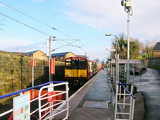
Dalry railway station is a railway station serving the town of Dalry, North Ayrshire, Scotland. The station is managed by ScotRail and is on the Ayrshire Coast Line.
The City of Glasgow Union Railway - City Union Line, also known as the Tron Line, was a railway company founded in Glasgow, Scotland, in 1864 to build a line connecting the railway systems north and south of the River Clyde, and to build a central passenger terminus and a general goods depot for the city. The through line, running from south-west to north-east across the city, opened in 1870–1, and the passenger terminal was St Enoch railway station, opened in 1876. The railway bridge across the Clyde was the first in the city.
Glasgow Airport railway station is a planned railway station to serve Glasgow Airport, Scotland. Originally intended to open in 2010, the station would be the western terminus of the Glasgow Airport Rail Link (GARL) before it was cancelled in 2009 but revived in 2016 as a light rail link. Four tram- trains an hour would run between Glasgow Airport and Glasgow Central stations, with one stop at Paisley Gilmour Street being proposed to be operated by Abellio ScotRail.

The Glasgow Airport Rail Link (GARL) is a proposed link between Glasgow City Centre and Glasgow Airport. The original plans for an airport rail link were proposed during the 2000s to directly link Glasgow Central station with Glasgow Airport in Scotland. The link was intended for completion by 2013 and would have had a service of four trains per hour via Paisley Gilmour Street railway station.

The Paisley Gilmour Street rail accident occurred on 16 April 1979 at 19:50. The 19:40 Inverclyde Line service from Glasgow Central to Wemyss Bay, operated by two Class 303 trains, crossed from the Down Fast Line to the Down Gourock Line under clear signals at Wallneuk Junction immediately to the east of Paisley Gilmour Street railway station. It collided head-on with the 18:58 Ayrshire Coast Line special service from Ayr to Glasgow Central, formed of two Class 126 diesel multiple units, which had left Platform 2 against a red signal P31.

Arkleston Junction is a railway junction east of the town of Paisley, Renfrewshire, Scotland. The junction is one mile from Paisley Gilmour Street railway station and is heavily used by both passenger and freight traffic.
The Glasgow and Paisley Joint Railway was the section of railway line between Glasgow Bridge Street railway station and Paisley, in the west of Scotland. It was constructed and operated jointly by two competing railway companies as the stem of their lines to Greenock and Ayr respectively, and it opened in 1840. The Joint Committee, which controlled the line, built a branch to Govan and later to Cessnock Dock, and then Prince's Dock.

Glasgow Shields Road ETD is a railway electric traction depot in Glasgow, Scotland. The depot is located on the south side of the Glasgow Central to Paisley lines, adjacent to Shields Junction and close to the site of the former Shields Road station. The depot's code is 'GW'.
The Lanarkshire and Ayrshire Railway (L&AR) was an independent railway company built to provide the Caledonian Railway with a shorter route for mineral traffic from the coalfields of Lanarkshire to Ardrossan Harbour, in Scotland.
The Dalry and North Johnstone Line was a branch of the Glasgow and South Western Railway (G&SWR) in Renfrewshire and Ayrshire, Scotland, connecting the stations in Elderslie and Dalry via a route running parallel to the existing line built by the Glasgow, Paisley, Kilmarnock and Ayr Railway. This provided additional line capacity for Ayrshire Coast and Kilmarnock services. The loop line was used for passenger services until the mid-1960s, when it was closed by the Beeching Axe. The majority of the line's trackbed has since been absorbed into the Sustrans National Cycle Network.

The Glasgow, Paisley, Kilmarnock and Ayr Railway (GPK&AR) was a railway in Scotland that provided train services between Glasgow, Kilmarnock and Ayr. It opened its first line, between Glasgow and Ayr, in stages from 1839 to 1840. The section between Glasgow and Paisley was made jointly with the Glasgow, Paisley and Greenock Railway. Later it built a line from Dalry via Kilmarnock to Cumnock, linking there with the Glasgow, Dumfries and Carlisle Railway, and together forming a through route from Glasgow to Carlisle. The two companies merged to form the Glasgow and South Western Railway.
The Largs Branch is a railway line in Scotland, serving communities on the north Ayrshire Coast, as well as the deep water ocean terminal at Hunterston. It branches from the Glasgow to Ayr line at Kilwinning.
The Maybole and Girvan Junction Railway was a railway company that constructed a line between Maybole and Girvan. Although promoted independently, it was supported by the Glasgow and South Western Railway, and was seen as part of a trunk line connecting Glasgow with a ferry port for the north of Ireland.
The Paisley and Barrhead District Railway was a railway in Scotland that ran between the towns of Paisley and Barrhead. It was intended to serve industrial premises and develop local passenger and goods business.
The Scotland Route Utilisation Strategy is a Route Utilisation Strategy, published by Network Rail in March 2007, the third RUS to be published. The railways in Scotland are divided into three strategic routes, namely Route 24, Route 25 (Highlands) and Route 26 together with parts of Route 8 and Route 18. The three strategic routes form the scope of Network Rail's Scotland Route Utilisation Strategy. Separate RUSs for the ECML and WCML encompass the relevant parts of routes 8 and 18. The Edinburgh Crossrail service, which provides a direct route between Stirling, Dunblane and Bathgate in the west to Newcraighall in the east, operates over part of the ECML east of Edinburgh Waverley to Portobello Junction.