
Afghanistan is a landlocked mountainous country located at the crossroads of Central and South Asia. It is also sometimes included as part of the Middle East. The country is the 40th largest in the world in size. Kabul is the capital and largest city of Afghanistan, located in the Kabul Province. With a location at the intersection of major trade routes, Afghanistan has attracted a succession of invaders since the sixth century BCE.

The Geography of Pakistan is a profound blend of landscapes varying from plains to deserts, forests, and plateaus ranging from the coastal areas of the Arabian Sea in the south to the mountains of the Karakoram, Hindukush, Himalayas ranges in the north. Pakistan geologically overlaps both with the Indian and the Eurasian tectonic plates where its Sindh and Punjab provinces lie on the north-western corner of the Indian plate while Balochistan and most of the Khyber Pakhtunkhwa lie within the Eurasian plate which mainly comprises the Iranian Plateau. Gilgit-Baltistan and Azad Kashmir lie along the edge of the Indian plate and are prone to violent earthquakes where the two tectonic plates collide.
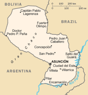
Paraguay is a country in South America, bordering Brazil, Argentina and Bolivia. The Paraguay River divides the country into strikingly different eastern and western regions. Both the eastern region and the western region gently slope toward and are drained into the Paraguay River, which separates and unifies the two regions. With the Paraneña region reaching southward and the Chaco extending to the north, Paraguay straddles the Tropic of Capricorn and experiences both subtropical and tropical climates.

The Lepontine Alps are a mountain range in the north-western part of the Alps. They are located in Switzerland and Italy.

The Sulaiman Mountains or Kōh-e Sulaymān are a north–south extension of the southern Hindu Kush mountain system in Pakistan and Afghanistan. They rise to form the eastern edge of the Iranian Plateau and the northeastern edge of the Balochistan Plateau. They are located in the Zabul, Kandahar and Loya Paktia regions of Afghanistan, and in Pakistan they extend over the northern part of Balochistan province, and some parts of southwestern Khyber Pakhtunkhwa and Punjab. Bordering the Sulaimans to the north are the arid highlands of the Central Hindu Kush, whose heights extend up to 3,383 metres (11,099 ft), and to the east are the plains of the Indus River valley. Together with the Kirthar Mountains in southern Pakistan, they form what is known as the Sulaiman-Kirthar geologic province.

The Chagai Hills is a range of granite hills in the Chagai District in Pakistan's Balochistan province.

The Grand Combin is a mountain massif in the western Pennine Alps in the canton of Valais. At a height of 4,314 metres (14,154 ft) the summit of Combin de Grafeneire is one of the highest peaks in the Alps and the second most prominent of the Pennine Alps. The Grand Combin is also a large glaciated massif consisting of several summits, among which three are above 4000 metres. The highest part of the massif is wholly in Switzerland, although the border with Italy lies a few kilometres south.

The Monashee Mountains are a mountain range lying mostly in British Columbia, Canada, extending into the U.S. state of Washington. They stretch 530 km (329 mi) from north to south and 150 km (93 mi) from east to west. They are a sub-range of the Columbia Mountains. The highest summit is Mount Monashee, which reaches 3,274 m (10,741 ft). The name is from the Scottish Gaelic monadh and sìth, meaning "moor" and "peace".

Panjgur is a district in the west Balochistan province of Pakistan. Panjgur was one of three districts of Makran District until 1 July 1977, when the district became a part of Makran Division. The other two districts of Makran Division are Kech (Turbat) and Gwadar. Chitkan is the district headquarter. Panjgur has sixteen (16) Union Councils.
Blake Fell is a hill in the Western part of the English Lake District. It is the highest point of the Loweswater Fells, an area of low grassy hills with steep sides overlooking the lake of Loweswater. The fell also overlooks the village of Loweswater, from which it can be climbed. An alternative route is from the Cogra Moss reservoir on its western slopes. Because the Loweswater Fells are a separate geographical unit, Blake Fell is a Marilyn. It is located in the Parish of Lamplugh.
Mellbreak is a hill in the Western part of the English Lake District. Despite being surrounded on all sides by higher fells, it stands in isolation. It is surrounded on three sides by a "moat" of deep marshy land, and on the east side by the lake of Crummock Water. The fell forms a partnership with the lake, running parallel to it, falling sheer into it, and regularly providing the backdrop for pictures of it.
Hen Comb is a fell in the west of the English Lake District. One of the Loweswater Fells it lies to the south of Loweswater lake and Loweswater village. Although of only moderate height, its ascent can be difficult as it is largely surrounded by bogs.

The Western Fells are a group of hills in the English Lake District. Centred on Great Gable they occupy a triangular area between Buttermere and Wasdale. The Western Fells are characterised by high ridges and an abundance of naked rock.
The Rakshan River rises at the Nidoki pass, south-west of Shireza, district Washuk, Balochistan, Pakistan.
Parom is a Tehsil in Panjgur District in Balochistan, Pakistan. The historical area of Parom was divided by the Goldsmith line, thus a small part of it falls in Iranian territory. According to local legend, it was also known as Gulshan, meaning 'rose garden'. The word parom means 'growth' in the Balochi language and is attributed to Parom due to its mild climate and the fertile soil which supports more than one crop per year. Today the region has two union councils, Parom and Koh Bun. The population numbers around 50,000 people.

The topography of Pakistan is divided into seven geographic areas: the northern highlands, the Indus River plain, the desert areas, the Pothohar Plateau, Balochistan Plateau, Salt Range, and the Sistan Basin. All the rivers of Pakistan, i.e. Sindh, Ravi River, Chenab River, Jhelum River, and Sutlej River, originate from the Himalayas mountain range. Some geographers designate Plateau as to the west of the imaginary southwest line; and the Indus Plain lies to the east of that line.
Tourism in Balochistan is a developing industry, and is overseen by the Tourism Directorate under the Government of Balochistan. Balochistan is known for its long coastal belt which extends from Karachi through Sonmiani, Ormara, Kalmat, Pasni, Gwadar, Jiwani and all the way up to Iran. It is also popular for its hill tops and rugged mountainous terrain.

Washuk District is a district in Balochistan province of Pakistan. Washuk, the district headquarters, is located at the center of the district.

Mullazai (ملازئی) is a Baloch tribe found in Panjgur District (پنجگور) of Balochistan, Pakistan and Tank District of Khyber Pakhtunkhwa, Pakistan. They are known as 'Mullas' and are descendants of Mir Mulla Shehsawar, who they claim to have migrated from Iran Sarbaz in 1513AD. The Mullazai tribe numbers in Panjgur are about 200 families or about 5000 persons. Other tribes associated with the Mullazai settled in Panjgur, Mastung, Sorab, Kalat, Kharan, Quetta, Kucklak, Nushki, Dalbandin, Qandahar and Iran.

