
The McKenzie River is a 90-mile (145 km) tributary of the Willamette River in western Oregon in the United States. It drains part of the Cascade Range east of Eugene and flows westward into the southernmost end of the Willamette Valley. It is named for Donald McKenzie, a Scottish Canadian fur trader who explored parts of the Pacific Northwest for the Pacific Fur Company in the early 19th century. As of the 21st century, six large dams have been built on the McKenzie and its tributaries.

The Malheur River is a 190-mile-long (306 km) tributary of the Snake River in eastern Oregon in the United States. It drains a high desert area, between the Harney Basin and the Blue Mountains and the Snake.

The Pit River is a major river draining from northeastern California into the state's Central Valley. The Pit, the Klamath and the Columbia are the only three rivers in the U.S. that cross the Cascade Range.

The Harney Basin is an endorheic basin in southeastern Oregon in the United States at the northwestern corner of the Great Basin. One of the least populated areas of the contiguous United States, it is located largely in northern Harney County, bounded on the north and east by the Columbia Plateau—within which it is contained, physiographically speaking—and on the south and west by a volcanic plain. The basin encompasses an area of 1,490 square miles (3,859 km2) in the watershed of Malheur Lake and Harney Lake. Malheur Lake is a freshwater lake, while Harney Lake is saline-alkaline.

The Bull Run River is a 21.9-mile (35.2 km) tributary of the Sandy River in the U.S. state of Oregon. Beginning at the lower end of Bull Run Lake in the Cascade Range, it flows generally west through the Bull Run Watershed Management Unit (BRWMU), a restricted area meant to protect the river and its tributaries from contamination. The river, impounded by two artificial storage reservoirs as well as the lake, is the primary source of drinking water for the city of Portland, Oregon.
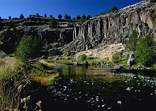
The Donner und Blitzen River is a river on the eastern Oregon high desert that drains a relatively arid basin, the southern portion of Harney Basin, from roughly 20 to 80 miles south-southeast of Burns including Malheur National Wildlife Refuge. Though much of its course is marsh, it offers scenic glaciated canyons, unique ecosystems, and exceptional wild trout fisheries. Named by soldiers of German origin, the Donner und Blitzen River translates as "thunder and lightning". The name usually brings to mind two of Santa Claus's reindeer, but the river is named for a thunderstorm the soldiers experienced as they crossed the river; dry lightning is an almost daily occurrence in the region during certain times of the year.

The Klamath Basin is the region in the U.S. states of Oregon and California drained by the Klamath River. It contains most of Klamath County and parts of Lake and Jackson counties in Oregon, and parts of Del Norte, Humboldt, Modoc, Siskiyou, and Trinity counties in California. The 15,751-square-mile (40,790 km2) drainage basin is 35% in Oregon and 65% in California. In Oregon, the watershed typically lies east of the Cascade Range, while California contains most of the river's segment that passes through the mountains. In the Oregon-far northern California segment of the river, the watershed is semi-desert at lower elevations and dry alpine in the upper elevations. In the western part of the basin, in California, however, the climate is more of temperate rainforest, and the Trinity River watershed consists of a more typical alpine climate.

The Crooked River is a tributary, 125 miles (201 km) long, of the Deschutes River in the U.S. state of Oregon. The river begins at the confluence of the South Fork Crooked River and Beaver Creek. Of the two tributaries, the South Fork Crooked River is the larger and is sometimes considered part of the Crooked River proper. A variant name of the South Fork Crooked River is simply "Crooked River". The Deschutes River flows north into the Columbia River.

The Cascades ecoregion is a Level III ecoregion designated by the United States Environmental Protection Agency (EPA) in the U.S. states of Washington, Oregon, and California. Somewhat smaller than the Cascade mountain range for which it is named, the ecoregion extends north to Snoqualmie Pass, near Seattle, and south to Hayden Pass, near the Oregon-California border, including the peaks and western slopes of most of the High Cascades. A discontiguous section is located on Mount Shasta in California.
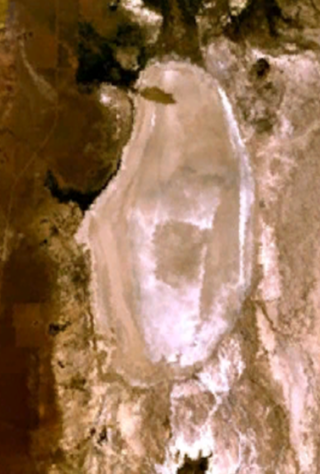
Alvord Lake is a seasonal shallow alkali lake in Harney County of the U.S. state of Oregon. Its elevation is 4,026 feet (1,227 m). It is located about 10 miles (16 km) southeast of Alvord Desert in the Alvord Basin and serves as terminus for all its streams. Its water level varies from dry to several feet deep. The nearest habitation is tiny Fields, 14.1 kilometres (8.8 mi) SSW.

The Trout Creek Mountains are a remote, semi-arid Great Basin mountain range mostly in southeastern Oregon and partially in northern Nevada in the United States. The range's highest point is Orevada View Benchmark, 8,506 feet (2,593 m) above sea level, in Nevada. Disaster Peak, elevation 7,781 feet (2,372 m), is another prominent summit in the Nevada portion of the mountains.

Little Butte Creek is a 17-mile-long (27 km) tributary of the Rogue River in the U.S. state of Oregon. Its drainage basin consists of approximately 354 square miles (917 km2) of Jackson County and another 19 square miles (49 km2) of Klamath County. Its two forks, the North Fork and the South Fork, both begin high in the Cascade Range near Mount McLoughlin and Brown Mountain. They both flow generally west until they meet near Lake Creek. The main stem continues west, flowing through the communities of Brownsboro, Eagle Point, and White City, before finally emptying into the Rogue River about 3 miles (5 km) southwest of Eagle Point.

Salmon Falls Creek is a tributary of the Snake River, flowing from northern Nevada into Idaho in the United States. Formed in high mountains at the northern edge of the Great Basin, Salmon Falls Creek flows northwards 121 miles (195 km), draining an arid and mountainous basin of 2,103 square miles (5,450 km2). The Salmon Falls Creek valley served as a trade route between the Native American groups of the Snake River Plain and Great Basin. Today, most of its water is used for irrigation.

Big Cottonwood Creek is located in the Wasatch Mountains just east of Salt Lake City. It is part of the Big Cottonwood Creek Watershed, which ranges in elevation from 5,000 to 10,500 feet with the headwaters around 9,600 feet. The creek flows through the Big Cottonwood Canyon in a westerly direction until it emerges into Salt Lake Valley about eighteen miles (29 km) from its highest source. Thence its course is northwesterly through Cottonwood Heights, Holladay, and Murray, Utah for a little over twenty-four miles from the headwaters until it empties into the Jordan River about five miles (8.0 km) south of Salt Lake City. The water eventually flows into the Great Salt Lake. In the summer, its waters are all used for irrigation purposes. From its source to its original outlet in the Jordan River is about twenty-six miles.
Trout Creek is a 51-mile (82 km) long tributary of the Deschutes River in the U.S. state of Oregon. It drains approximately 692 square miles (1,792 km2) of Crook, Jefferson, and Wasco counties. Arising in the Ochoco Mountains, it flows north and then west to its confluence with the Deschutes River.
The North Fork Malheur River is a 59-mile (95 km) tributary of the Malheur River in eastern Oregon in the United States. Rising in Big Cow Burn in the Blue Mountains, it flows generally south to join the larger river at Juntura. The upper 25.5 miles (41.0 km) of the river have been designated Wild and Scenic. This part of the river basin offers camping, hiking, and fishing opportunities in a remote forest setting. The lower river passes through Beulah Reservoir, which stores water for irrigation and has facilities for boaters.
Rock Creek is a 56-mile (90 km) intermittent stream flowing in Lake and Harney counties in the U.S. state of Oregon. The source of Rock Creek is at an elevation of 6,914 feet (2,107 m) on Hart Mountain, while the mouth is at an elevation of 4,557 feet (1,389 m) in the Catlow Valley. Rock Creek has a 269-square-mile (700 km2) watershed.
Willow Creek is a 57-mile (92 km) tributary of the Malheur River in Malheur County in the U.S. state of Oregon. The creek, which forms at 3,724 feet (1,135 m) above sea level and ends at 2,234 feet (681 m), flows generally southeast between Ironside and Vale. Willow Creek's watershed covers 787 square miles (2,040 km2) of relatively arid land.

Salt Creek is a 30-mile (48 km) tributary of the Middle Fork Willamette River in Lane County in the U.S. state of Oregon. It is named for salt springs along its banks that are used as licks by deer. The stream originates as an outflow of Lower Betty Lake in the forested Cascade Range just southeast of Waldo Lake. It proceeds generally south, through Gold Lake, to Route 58, which it then follows mainly northwest for about 26 miles (42 km) to its mouth at the Middle Fork Willamette River just below Hills Creek Dam. At Salt Creek Falls—roughly 4 miles (6.4 km) west of Willamette Pass and a little more than 22 miles (35 km) upstream from the mouth—the stream plunges 286 feet (87 m), discharging an average of 50,000 U.S. gallons (190,000 L) of water per minute, or 111 cubic feet per second (3.1 m3/s). Below the falls, the creek enters a narrow canyon shaped by glaciation and basaltic lava flows from higher in the Cascades. McCredie Hot Springs, at the former community of McCredie Springs, are natural hot springs along the lower half of Salt Creek beside Route 58.

Rivers and creeks in Lake County, California are listed below by river basin and alphabetically. Unless otherwise stated, the information is taken from the Geographic Names Information System maintained by the United States Geological Survey. Coordinates, elevations and lengths from this source are approximate.

